Alessandro Chiarucci?' Brett H. Robinson 23), Ilaria Bonini!,, , Daniel Petit3) Robert R. Brooks & Vincenzo De Dominicis!)
1) Dipartimento di Biologia Ambientale, Università degli Studi di Siena, Via P.A. Mattioli 4, 1-53100 Siena, Italy; fax +39 577 298860, E-mail chiarucci@unisi.it 2) Department of Soil Science, Massey University, Private bag 11222, Palmerston North, New Zealand; fax +64 6 350 5632, E-mail r.brooks@massey.ac.nz.
3) Laboratoire de Génétique et Evolution, CNRS, Université de Lille, F-59655 Villeneuve d'Ascq, France
Keywords: Canonical correspondence analysis, Drought, Serpentine, Soil features, Species diversity, Vegetation ecology
关键词:典范对应分析,干旱,蛇纹岩,土壤特征,物种多样性,植被生态学
Abstract: Vegetation and soil sampling were carried out in 80 plots located in five different ultramafic (serpentine) sites of Tuscany, central Italy. The physical and chemical features of each plot were determined and the species composition and cover recorded. The exchangeable fraction of soil metals was analysed because it gives a measure of their concentrations available to plants. The plots were classified by cluster analysis and ANOVA was used to compare the environmental variables of the groups of plots. Canonical correspondence analysis was used to detect the principal factors for gradients of species composition within the plant communities. A higher content of exchangeable metals was found under the more evolved and structured plant communities, suggesting that serpentine vegetation of Tuscany is not strongly limited by soil metals, such as chromium, cobalt, nickel and magnesium, typically associated with ultramafic soils. The low nutrient content of the soils and drought stress mainly due to topographical features, appear to have a more significant role in determining the typical scattered vegetation of the Tuscan ultramafics.
摘要:在意大利中部托斯卡纳5个不同超基性(蛇纹岩)样地中布设的80个样方内开展了植被与土壤调查采样。测定了各样方的理化特征,并记录了物种组成与盖度。由于土壤金属的可交换态能够反映其对植物有效的浓度,本研究对其进行了分析。采用聚类分析对样方进行分类,并采用ANOVA比较各样方组之间的环境变量。利用典范对应分析识别植物群落内部物种组成梯度的主要影响因子。结果表明,在发育程度更高、结构更完善的植物群落下,土壤可交换态金属含量更高,这说明托斯卡纳的蛇纹岩植被并未受到超基性土壤中典型的铬、钴、镍和镁等土壤金属的强烈限制。土壤养分含量低以及主要由地形特征导致的干旱胁迫,似乎在形成托斯卡纳超基性土壤上典型的稀疏植被方面发挥着更为重要的作用。
1INTRODUCTION引言
Ultramafic (serpentine) soils host a distinctive flora and vegetation. The stunted plants and patches of bare soil have been attributed to the chemical and physical features of ultramafic soils. These typically contain high concentrations of heavy metals such as nickel, chromium, cobalt, and manganese, low concentrations of nutrients and a large excess of magnesium over calcium; moreover these soils are shallow, well drained and prone to erosion (BRooks 1987, BAKER et al. 1992, ROBERTS & PROCTOR 1992). However, large variations exist in the soil features of the different sites. PROCTOR & NAGY (1992) suggested that the factors controlling ultramafic flora might differ from site to site.
超基性(蛇纹岩)土壤上分布着独特的植物区系和植被。植株矮小和斑块状裸露土壤的现象被归因于超基性土壤的化学和物理特征。这类土壤通常含有高浓度的重金属(如镍、铬、钴和锰),养分浓度低,且镁相对于钙严重过量;此外,这类土壤土层浅薄、排水良好且易受侵蚀(BRooks 1987, BAKER et al. 1992, ROBERTS & PROCTOR 1992)。然而,不同样地之间的土壤特征存在很大差异。PROCTOR & NAGY(1992)认为,控制超基性植物区系的因子可能因地而异。
There are several ultramafic outcrops in Tuscany, Italy, and their flora and vegetation have been widely studied by botanists and ecologists (see VERGNANO GAMBI 1992). The most typical plant community of Tuscan ultramafic soils is a garigue, described as the Armerio-Alyssetum bertolonii association, which is characterised by low ground cover and several endemic species (ARRIGONIet al. 1983, CHIARUCCI et al. 1995). This vegetation type occurs, differentiated into two sub-associations, over all ultramafic outcrops of luscany (CHIARUCCI et al. 1995). Tall scrub or woodland plant communities have also been reported and are widespread in some sites (MESSERI 1936, PICHI-SERMOLLI 1948, MARCHIORI & TORNADORE MARCHIORI 1977, CHIARUCCI 1994). Some authors (e.g. SASSE 1979a, b, ARRIGONI et al. 1983, VERGNANO GAMBI 1992) have claimed that soil metal content negatively affects plant communities. Others have hypothesised that soil metal content does not affect vegetation when nutrients are available (CHIARUCCI & DE DOMINICIS 1995, CHIARUCCI 1996). In spite of the several papers published on the flora, vegetation and metal uptake by plants, only a few studies have thoroughly investigated the relations between environmental features and vegetation composition and structure (CHIARUCCI et al. 1998).
意大利托斯卡纳分布有若干超基性岩露头,植物学家和生态学家已对其植物区系和植被进行了广泛研究(见VERGNANO GAMBI 1992)。托斯卡纳超基性土壤上最典型的植物群落是一种加里格群落(garigue),被描述为Armerio-Alyssetum bertolonii群丛,其特征是地面盖度低并含有多种特有种(ARRIGONIet al. 1983, CHIARUCCI et al. 1995)。该植被类型分化为两个亚群丛,出现于托斯卡纳所有超基性岩露头上(CHIARUCCI et al. 1995)。高灌丛或林地植物群落亦有报道,并在部分样地中广泛分布(MESSERI 1936, PICHI-SERMOLLI 1948, MARCHIORI & TORNADORE MARCHIORI 1977, CHIARUCCI 1994)。部分作者(如SASSE 1979a, b, ARRIGONI et al. 1983, VERGNANO GAMBI 1992)认为土壤金属含量对植物群落具有负面影响。另一些作者则推测,在养分充足时土壤金属含量并不影响植被(CHIARUCCI & DE DOMINICIS 1995, CHIARUCCI 1996)。尽管已有若干关于植物区系、植被及植物金属吸收的论文发表,但仅有少数研究深入探讨了环境特征与植被组成和结构之间的关系(CHIARUCCI et al. 1998)。
The aim of the present paper was to describe the species diversity and composition of the plant communities growing over the most important ultramafic outcrops of Tuscany in relation to the main environmental features, with particular attention to the exchangeable soil metal content.
本文旨在描述托斯卡纳最重要的超基性岩露头上植物群落的物种多样性与组成及其与主要环境特征的关系,并特别关注土壤可交换态金属含量。
2MATERIALS AND METHODS材料与方法
Study areas and vegetation sampling研究区与植被采样
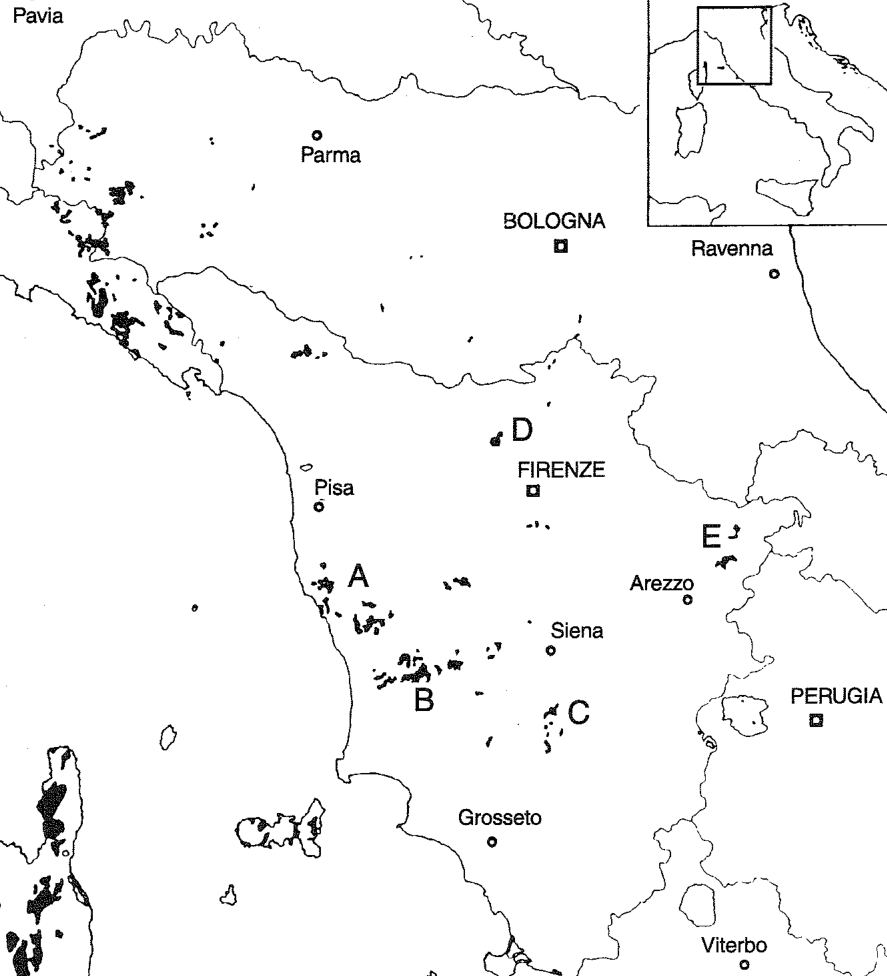
Five of the largest ultramafic areas in Tuscany were selected as study sites (Fig. 1): the hills near Livorno, the Cecina Valley and surrounding areas, the Murlo area, Mt. Ferrato and the upper Tiber Valley. Some 15-20 100 m? plots, representing all the main vegetation types, were sampled in each area in June 1996. The cover of all vascular species was estimated in each vegetation layer. The following features were recorded: altitude (m), aspect, slope (°), cover (%) and height (m) of the tree layer, cover (%) and height (m) of the shrub layer, field layer cover (%), rockiness (%) and stoniness (%). The index of normalised insolation (BARTORELLI 1967) was used as a heat index, summarising the interactive effects of latitude, slope and aspect on determining the amount of solar radiation that each plot receives during the year. This index based on the hours per year of overhead sunlight, is a measure of the radiation the site actually receives in one year, given its aspect, slope, and latitude. Plant nomenclature follows PIGNATTI (1982) for most species, CHIARUCCI et al. (1995) for serpentinophytes and MORALDO (1986) for the genus Stipa.
选取托斯卡纳5个面积最大的超基性区域作为研究样地(图1):利沃诺附近的丘陵、切奇纳河谷及周边地区、穆尔洛地区、费拉托山以及台伯河上游河谷。1996年6月,在每个区域内调查了约15~20个100 m²的样方,涵盖所有主要植被类型。估测了各植被层中全部维管植物物种的盖度。记录的特征包括:海拔(m)、坡向、坡度(°)、乔木层盖度(%)和高度(m)、灌木层盖度(%)和高度(m)、草本层盖度(%)、岩石裸露率(%)和砾石率(%)。采用标准化日照指数(BARTORELLI 1967)作为热量指数,综合反映纬度、坡度和坡向对各样方全年所接收太阳辐射量的交互作用。该指数基于每年直射日照时数,在给定坡向、坡度和纬度的条件下,衡量样地一年内实际接收的辐射量。植物命名方面,大多数物种依据PIGNATTI(1982),蛇纹岩植物依据CHIARUCCI et al.(1995),针茅属(Stipa)依据MORALDO(1986)。
Soil sampling and analysis土壤采样与分析
A composite soil sample was taken in each plot at about 10 cm of depth. Soil samples were air dried and passed through a 2 mm sieve. A 1: 2.5 soil-water suspension was used to measure pH; organic matter was estimated by measuring loss on ignition (LOI) after heating soil subsamples to 450 °C overnight. Exchangeable cations were determined by adding 30 ml of 1M CH3COONH4 to 3 g of soil in a polythene container and shaking the containers overnight. The solutions were filtered and analysed by flame atomic absorption spectroscopy. The exchangeable fraction, as opposed to the total metal concentration, was determined because it gives a measure of the concentration available to plants.
在每个样方中约10 cm深度处采集混合土样。土样经风干后过2 mm筛。采用1:2.5的土水悬液测定pH;有机质通过将土壤子样品在450 °C下加热过夜后测定烧失量(LOI)来估算。可交换性阳离子的测定方法为:在聚乙烯容器中向3 g土壤加入30 ml 1M CH3COONH4,振荡过夜。溶液经过滤后采用火焰原子吸收光谱法测定。之所以测定可交换态而非金属全量,是因为前者能够反映对植物有效的浓度。
Data analysis数据分析
Because of the climatic and phytogeographic differences between the Mediterranean (the first three sites) and the inland (Mt. Ferrato and Upper Tiber Valley) sites (ARRIGONI 1980, CHIARUCcI et al. 1995), the data-set was divided in two parts. The total cover of each species (not subdivided into three layers) was used for analysis. The plots were classified by a homogeneity-optimising procedure. Cluster analysis, using MNSSQ as agglomeration criterion, was applied to a distance matrix constructed on the basis of the similarity ratio (PODANI 1994). Data processing was performed with the SYN-TAX 5.0 program package (PODANI 1993). For the groups of plots identified by cluster analysis, soil and environmental data were compared by one-way ANOVA; statistical differences between groups were tested by the Duncan multiple-range test at P < 0.05. To satisfy the normality assumptions of statistical analysis, the variables LOI, rockiness, stoniness, and exchangeable cations were logarithmically transformed.
由于地中海样地(前三个样地)与内陆样地(费拉托山和台伯河上游河谷)之间存在气候和植物地理差异(ARRIGONI 1980, CHIARUCcI et al. 1995),将数据集分为两部分。分析采用各物种的总盖度(不再细分为三层)。采用同质性优化程序对样方进行分类。以相似比为基础构建距离矩阵(PODANI 1994),并以MNSSQ为聚合准则进行聚类分析。数据处理采用SYN-TAX 5.0程序包(PODANI 1993)。对聚类分析识别出的样方组,采用单因素ANOVA比较土壤和环境数据;组间统计差异采用Duncan多重极差检验(P < 0.05)。为满足统计分析的正态性假设,对LOI、岩石裸露率、砾石率及可交换性阳离子等变量进行了对数转换。
To detect gradients in species composition and in species-environment relations, canonical correspondence analysis (CCA) (TER BRAAK 1986) was performed by the program package CANOCO 3.11 (TER BRAAK 1988). Cover data were log-transformed and rare species were downweighted. A Monte Carlo permutation test was applied to test the significance of the eigenvalue corresponding to the first CCA canonical axis (TER BRAAK 1988).
为探测物种组成梯度及物种-环境关系,采用CANOCO 3.11程序包(TER BRAAK 1988)进行典范对应分析(CCA)(TER BRAAK 1986)。盖度数据经对数转换,并对稀有种进行降权处理。采用Monte Carlo置换检验检验CCA第一典范轴特征值的显著性(TER BRAAK 1988)。
3RESULTS结果
191 vascular plant species were found in the eighty 100 m? plots, of which 142 species were in the Mediterranean data set and 127 in the inland data set. The average species richness per plot was 25.1. The results are reported separately for the two data sets.
在80个100 m²的样方中共记录到191种维管植物,其中地中海数据集142种,内陆数据集127种。每个样方的平均物种丰富度为25.1。以下分别报告两个数据集的结果。
Mediterranean data set地中海数据集
Species composition and richness物种组成与丰富度
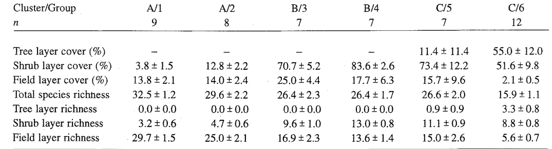
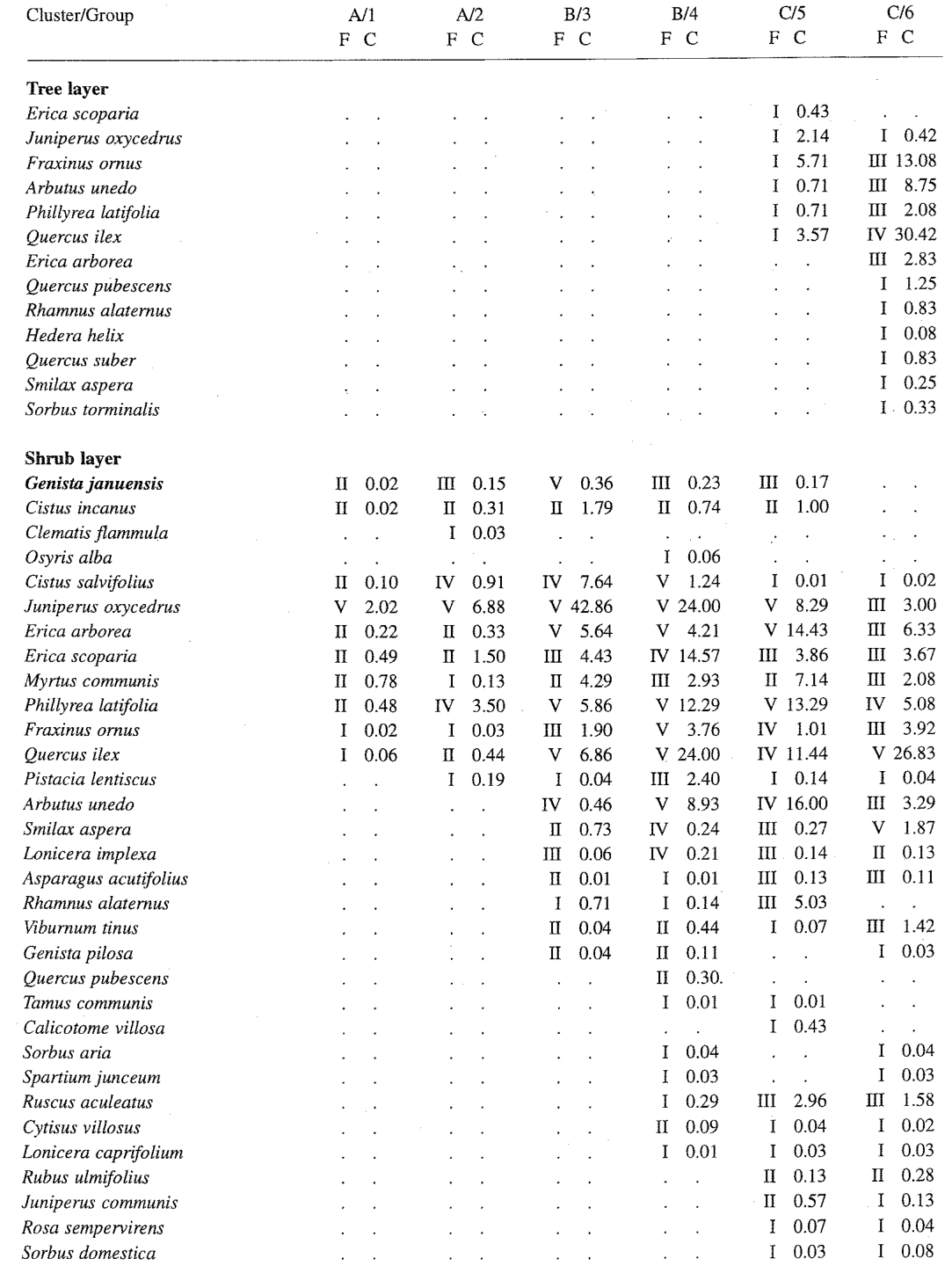
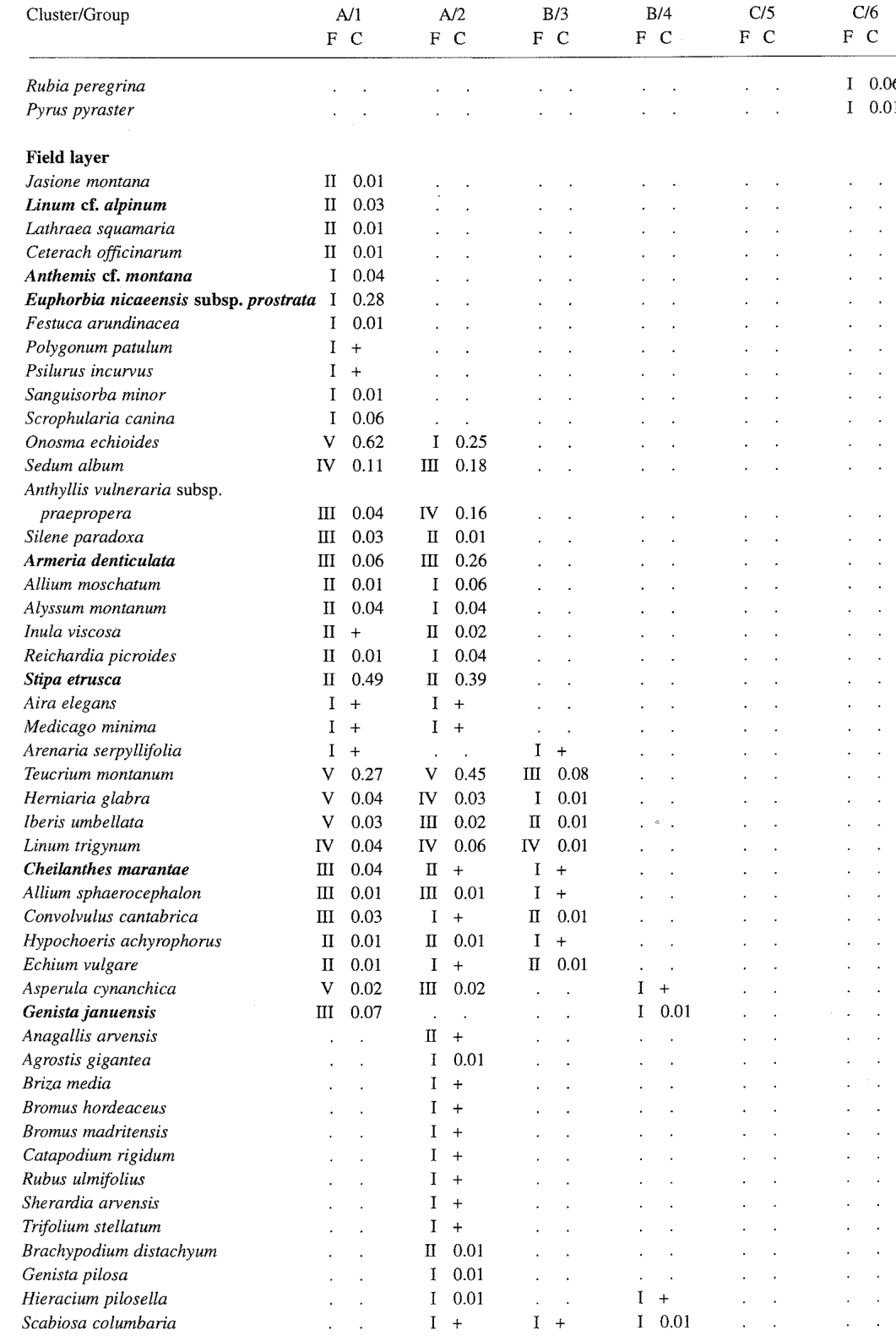
The main cluster divisions (not shown) were linked to floristic characters reflecting vegetation structure and diversity (Tab. 1). All groups contained plots from the three sites. Species frequency and cover in the six groups are reported in Tab. 2.
主要的聚类划分(未列出)与反映植被结构和多样性的植物区系特征相关(表1)。所有组均包含来自三个样地的样方。6个组中各物种的频度和盖度见表2。
Cluster A contained the vegetation types with low ground cover: the plots of Group 1 were sampled in typical garigues of the ultramafic sites of Mediterranean Tuscany, belonging to the Armerio-Alyssetum bertolonii euphorbietosum spinosae (CHIARUCCI et al. 1995), with a very low shrub cover. This vegetation type is characterised by several endemic plants, the most abundant of which is the nickel hyperaccumulator Alyssum bertolonii (ARRIGONI et al. 1983, CHIARUCCI et al. 1995). Group 2 included similar plant communities, but with a higher shrub cover mainly due to Juniperus oxycedrus subsp. oxycedrus and Phillyrea latifolia.
聚类A包含地面盖度较低的植被类型:第1组样方采自托斯卡纳地中海区超基性样地上的典型加里格群落,属于Armerio-Alyssetum bertolonii euphorbietosum spinosae(CHIARUCCI et al. 1995),灌木盖度很低。该植被类型以多种特有植物为特征,其中最为丰富的是镍超富集植物Alyssum bertolonii(ARRIGONI et al. 1983, CHIARUCCI et al. 1995)。第2组包含类似的植物群落,但灌木盖度较高,主要由Juniperus oxycedrus subsp. oxycedrus和Phillyrea latifolia构成。
Cluster B contained the plots sampled in xerophilous shrublands. The plots of Group 3 were in open juniper scrub communities, dominated by Juniperus oxycedrus subsp. oxycedrus, in which Cistus salvifolius, Quercus ilex, Phillyrea latifolia and Erica arborea were also abundant. The field layer was dense and rich, being characterised both by garigue species (Centaurea aplolepa subsp. carueliana, Galium corrudifolium, Stachys recta subsp. serpentini, Thymus striatus var. ophioliticus, Trinia glauca, Linum trigynum, Anthericum liliago) and xerophilous perennial graminoids (Bromus erectus, Festuca inops, F. robustifolia, Carex humilts). The plots of Group 4 were sampled in closed juniper scrub communities, in which the broad-leaved evergreen species (Quercus ilex, Arbutus unedo, Phillyrea latifolia) were more abundant than J. oxycedrus subsp. oxycedrus. Cover and richness of the field layer were
聚类B包含采自旱生灌丛的样方。第3组样方位于开放的刺柏灌丛群落中,以Juniperus oxycedrus subsp. oxycedrus为优势种,Cistus salvifolius、Quercus ilex、Phillyrea latifolia和Erica arborea亦较丰富。草本层茂密且物种丰富,既有加里格群落物种(Centaurea aplolepa subsp. carueliana, Galium corrudifolium, Stachys recta subsp. serpentini, Thymus striatus var. ophioliticus, Trinia glauca, Linum trigynum, Anthericum liliago),也有旱生多年生禾草类植物(Bromus erectus, Festuca inops, F. robustifolia, Carex humilts)。第4组样方采自郁闭的刺柏灌丛群落,其中阔叶常绿物种(Quercus ilex, Arbutus unedo, Phillyrea latifolia)比J. oxycedrus subsp. oxycedrus更为丰富。草本层的盖度和丰富度
Vegetation of Tuscan ultramafic soils托斯卡纳超基性土壤的植被
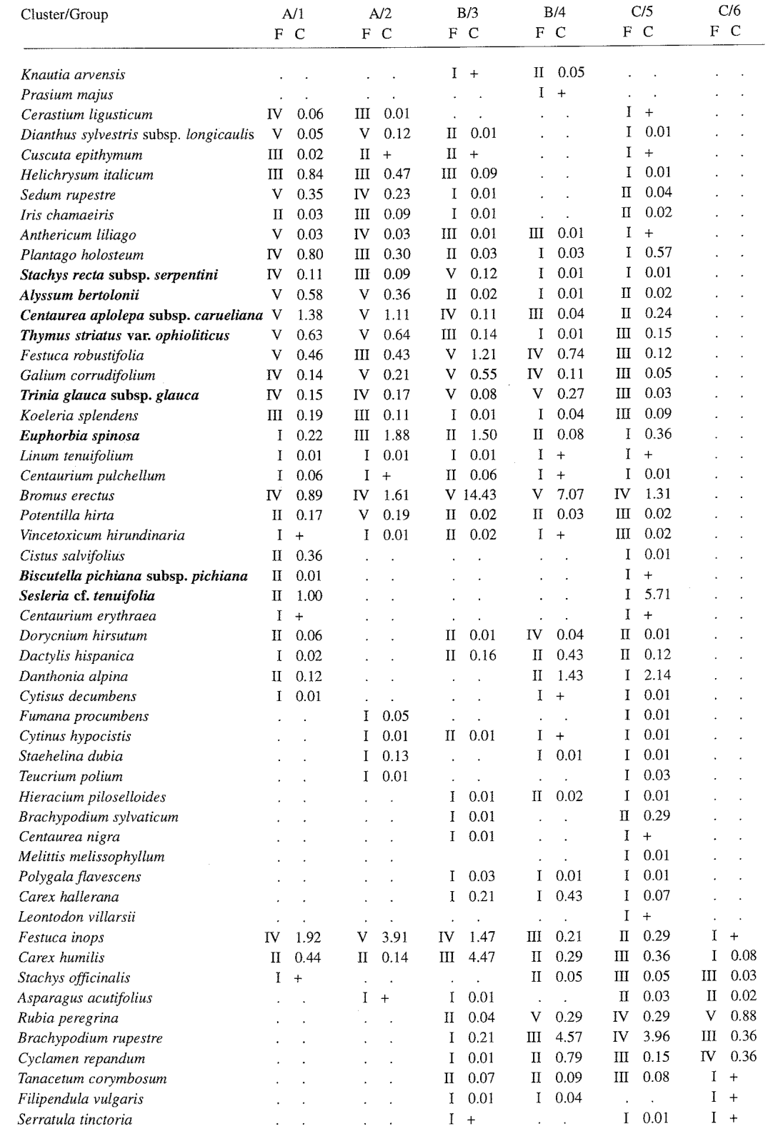
reduced because of the higher shrub cover. The garigue species and the xerophilous graminoids were almost totally absent, being partly replaced by Brachypodium rupestre and Rubia peregrina. The vegetation of these two groups has not yet been described from a phytosociological point of view.
因灌木盖度较高而降低。加里格群落物种和旱生禾草类植物几乎完全消失,部分被Brachypodium rupestre和Rubia peregrina所取代。这两组的植被尚未从植物社会学角度进行描述。
Cluster C, linked to cluster B, contained closed woody communities. Group 5 combined the plots sampled in closed maquis a few metres high, locally called "forteto", in which the Mediterranean broad-leaved evergreen species, together with Erica scoparia and E. arborea, played the main structural role, whereas J. oxycedrus subsp. oxycedrus was scarce. The field layer consisted of Brachypodium rupestre and several woodland species (Rubia peregrina, Stachys officinalis, Cyclamen repandum, Viola alba subsp. dehnhardtii). This vegetation type has been referred to the Viburno-Quercetum ilicis ericetosum (MARCHIORI & TORNADORE MARCHIORI 1977, CHIARUCCI 1994). The plots of Group 6 were in the most evolved communities, similar to Group 5 but with a structure often differentiated into three layers. This vegetation type was assigned to the Viburno-Quercetum ilicis ornetosum (MARCHIORI
聚类C与聚类B相关联,包含郁闭的木本群落。第5组汇集了采自高数米的郁闭马基斯群落(当地称为“forteto”)的样方,其中地中海阔叶常绿物种与Erica scoparia和E. arborea共同构成主要结构,而J. oxycedrus subsp. oxycedrus较为稀少。草本层由Brachypodium rupestre和多种林地物种(Rubia peregrina, Stachys officinalis, Cyclamen repandum, Viola alba subsp. dehnhardtii)组成。该植被类型被归入Viburno-Quercetum ilicis ericetosum(MARCHIORI & TORNADORE MARCHIORI 1977, CHIARUCCI 1994)。第6组样方位于发育程度最高的群落中,与第5组相似,但其结构常分化为三层。该植被类型被归入Viburno-Quercetum ilicis ornetosum(MARCHIORI
& TORNADORE MARCHIORI 1977, CHIARUCCI 1994). The field layer had a very low cover and low species richness.
& TORNADORE MARCHIORI 1977, CHIARUCCI 1994)。草本层盖度很低,物种丰富度也较低。
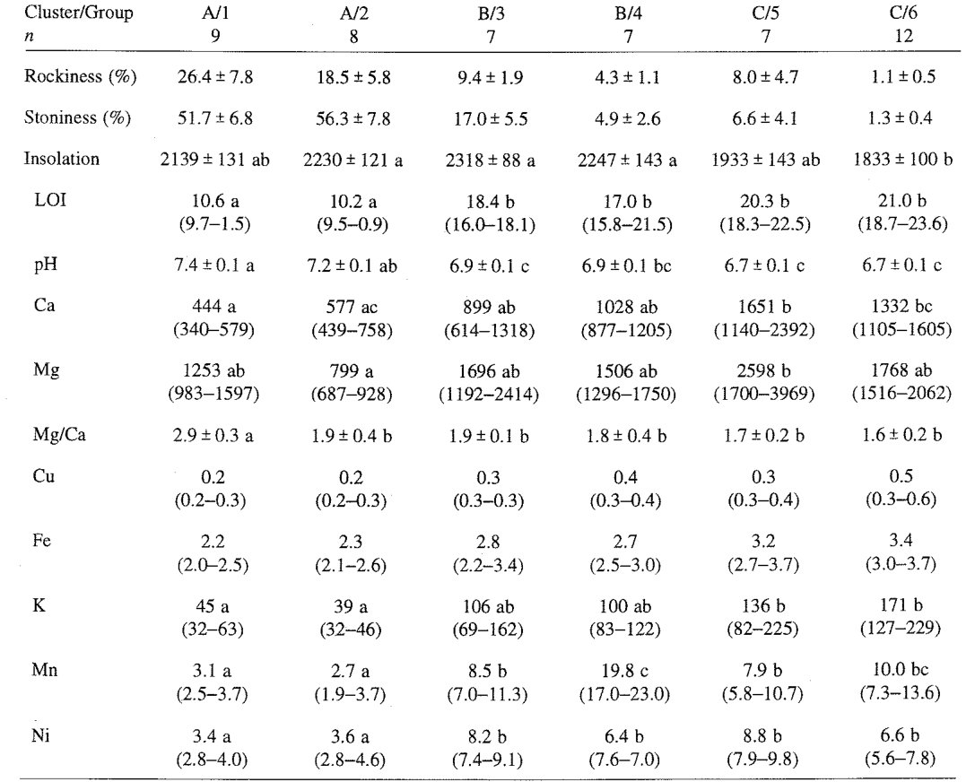
The main soil features are reported in Tab. 3. The results show that organic matter content and availability of metals increased trom garigue to woodland vegetation types, whereas the pH, rockiness and stoniness decreased. Insolation was higher in the shrubland community than in maquis and woodlands. In the garigue it had intermediate values. Chromium, which usually has high total concentrations in ultramafic soils (BROOKS 1987), was below the detection limit (< 0.5 ug/g) in the soil extracts. The Mg/Ca quotient, which has been regarded as important in controlling some serpentine floras (PROCTOR & NAGY 1992), was significantly higher only under the garigue vegetation.
主要土壤特征见表3。结果表明,从加里格群落到林地植被类型,有机质含量和金属有效性逐渐增加,而pH、岩石裸露率和砾石率则逐渐降低。灌丛群落的日照高于马基斯群落和林地,加里格群落的日照则介于二者之间。铬在超基性土壤中通常具有较高的全量浓度(BROOKS 1987),但在土壤提取液中低于检出限(< 0.5 ug/g)。Mg/Ca比值被认为对某些蛇纹岩植物区系具有重要的控制作用(PROCTOR & NAGY 1992),但仅在加里格植被下显著较高。
Gradient analysis梯度分析
The CCA ordering of plots and environmental variables is shown in Fig. 2. The cumulative percentage of variance explained by the first two axes accounted for 25.4% (19.9% and 5.5%) of the species data and 56.8% (44.6% and 12.2%) of the species-environment relations; the eigenvalue of the first canonical axis was highly significant (P < 0.01). The plot scattering according to the first two axes (Fig. 2) showed an evolutive trend from garigues to garigues with shrubs, open juniper scrub, closed juniper scrub, maquis and woods, from the positive to the negative values on the first axis. The first axis was positively correlated with rockiness, stoniness and pH and negatively with loss on ignition, whereas the second axis was positively correlated with altitude (Tab. 4). Exchangeable cations were negatively, but not significantly, correlated with the first axis, indicating increasing availability of these elements in the soil from the less to the more evolved communities.
样方与环境变量的CCA排序结果见图2。前两轴累计解释了物种数据方差的25.4%(分别为19.9%和5.5%)以及物种-环境关系的56.8%(分别为44.6%和12.2%);第一典范轴的特征值极显著(P < 0.01)。样方沿前两轴的分布(图2)显示,沿第一轴由正值向负值方向,存在从加里格群落到含灌木的加里格群落、开放刺柏灌丛、郁闭刺柏灌丛、马基斯群落直至林地的演替趋势。第一轴与岩石裸露率、砾石率和pH呈正相关,与烧失量呈负相关;第二轴则与海拔呈正相关(表4)。可交换性阳离子与第一轴呈负相关但不显著,表明从发育程度较低的群落到发育程度较高的群落,土壤中这些元素的有效性逐渐增加。
Inland data set内陆数据集
Species composition and richness物种组成与丰富度
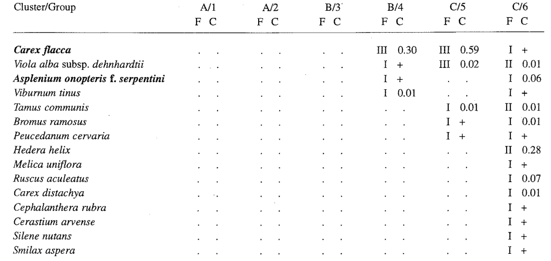
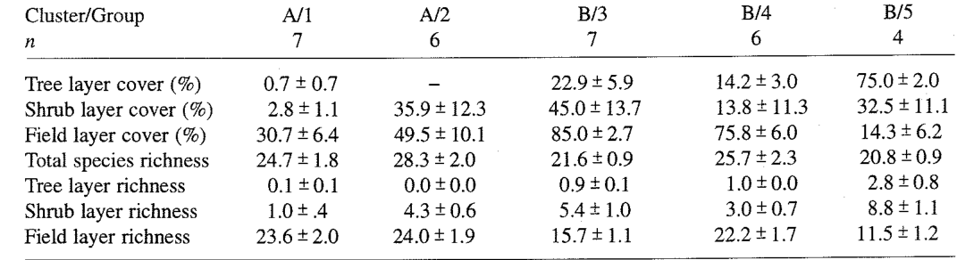
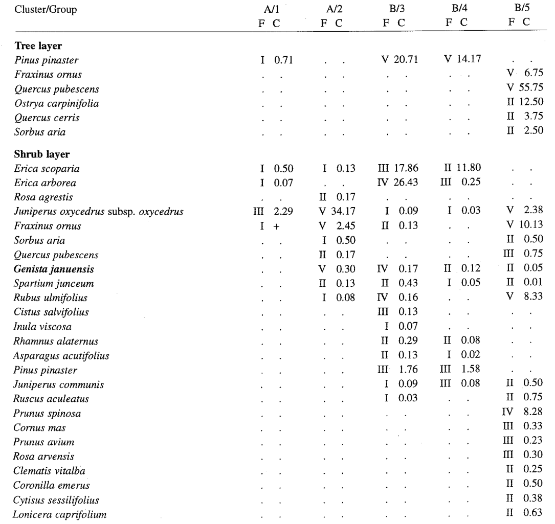
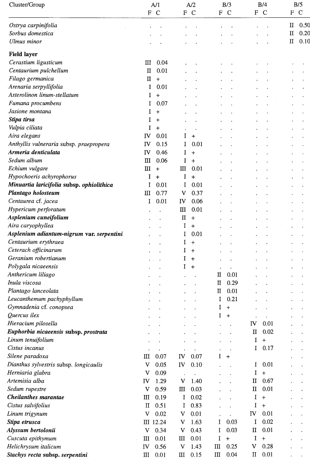
The two main clusters (not shown) pertained to the plant communities with high (A) and low (B) degrees of bare soil, differing in structure and species diversity (Tab. 5). The two groups of cluster A corresponded to Groups 1 and 2 of the Mediterranean data set but were slightly different in terms of flora (Tab. 6). In fact, the plots of Group 1 belonged to the Armerio-Alyssetum bertolonii typicum, which is reported for all the ultramafic sites of inland Tuscany (CHIARUCCI et al. 1995). Group 2 pertained to similar vegetation but with a higher ground cover and with a higher shrub cover, Juniperus oxycedrus subsp. oxycedrus and Fraxinus ornus being the most abundant shrubs.
两个主要聚类(未列出)分别对应裸地比例高(A)和低(B)的植物群落,二者在结构和物种多样性上存在差异(表5)。聚类A的两个组对应于地中海数据集的第1组和第2组,但在植物区系上略有不同(表6)。实际上,第1组样方属于Armerio-Alyssetum bertolonii typicum,该群丛在托斯卡纳内陆所有超基性样地中均有报道(CHIARUCCI et al. 1995)。第2组属于类似的植被,但地面盖度和灌木盖度较高,其中Juniperus oxycedrus subsp. oxycedrus和Fraxinus ornus是最为丰富的灌木。
Vegetation of Tuscan ultramafic soils托斯卡纳超基性土壤的植被
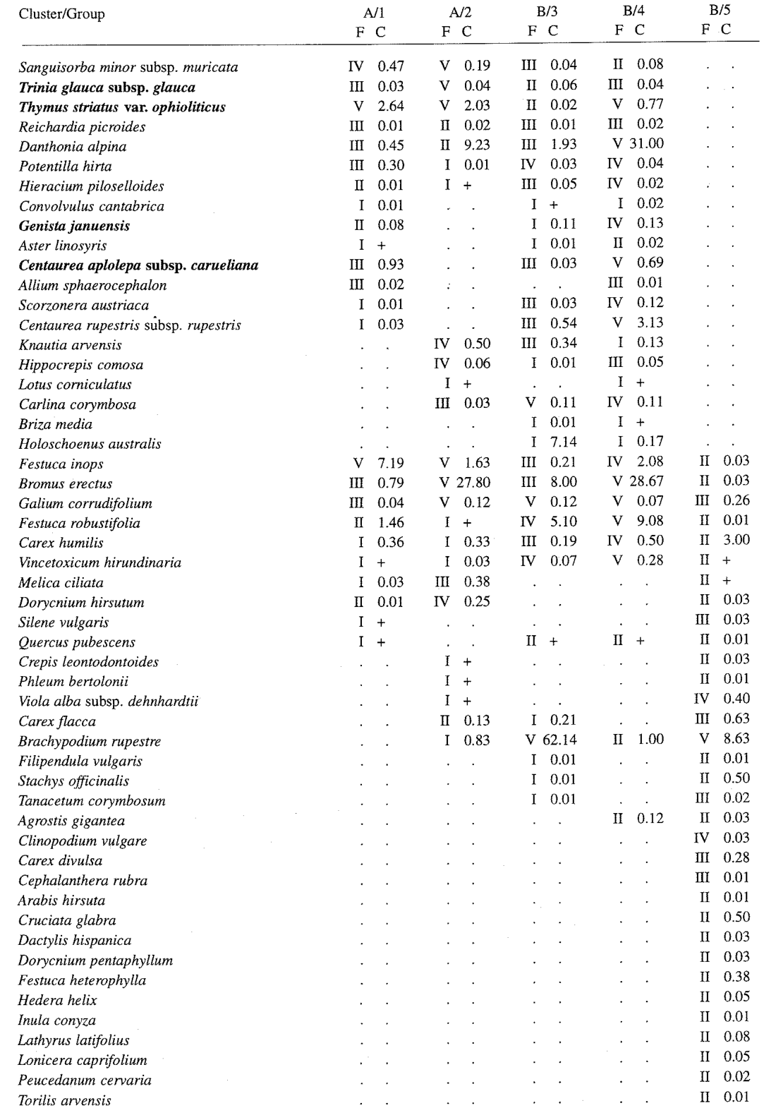
Cluster B contained markedly different vegetation types. Group 3 consisted of plots in grassland dominated by Brachypodium rupestre under a relatively dense pine (Pinus pinaster) canopy (20% of cover on average). The strong dominance of Brachypodium rupestre (mean cover 62%) reduced species richness in the field layer. Group 4 was formed by less strongly dominated grasslands under a lower pine cover (14% of cover on average). These evolve from garigues similar to those of group 1 because of the pine canopy, which protects against erosion and is responsible for an increase in nutrient input (CHIARUCCI & DE DOMINICIS 1995, CHIARUCCI 1996, CHIARUCCI et al. 1998) and probably they also evolve into the grasslands of Group 3. The plots of Groups 3 and 4 were sampled exclusively on Mt. Ferrato. The plots of Group 5, sampled in the Upper Tiber Valley, were recorded in the most evolved vegetation, i.e. woodlands dominated by Quercus pubescens and Fraxinus ornus. These communities were not common and, as observed by PICHI SERMOLLI (1948), were almost exclusively associated with less xeric conditions, such as slope-bottoms, or close to the ultramafic/non-ultramafic lithological ecotone.
聚类B包含差异明显的植被类型。第3组由位于较密集松树(Pinus pinaster)林冠(平均盖度20%)下、以Brachypodium rupestre为优势种的草地样方组成。Brachypodium rupestre的强烈优势(平均盖度62%)降低了草本层的物种丰富度。第4组由优势度较弱、位于较低松树盖度(平均盖度14%)下的草地构成。这些草地由与第1组相似的加里格群落演替而来,原因在于松树林冠能够防止侵蚀并增加养分输入(CHIARUCCI & DE DOMINICIS 1995, CHIARUCCI 1996, CHIARUCCI et al. 1998),并且它们很可能进一步演替为第3组的草地。第3组和第4组样方均仅采自费拉托山。第5组样方采自台伯河上游河谷,记录于发育程度最高的植被中,即以Quercus pubescens和Fraxinus ornus为优势种的林地。这些群落并不常见,且正如PICHI SERMOLLI(1948)所观察到的,几乎仅与较不干旱的条件相关联,如坡脚处或靠近超基性/非超基性岩性交错带的区域。
Soil and physical environment土壤与自然环境
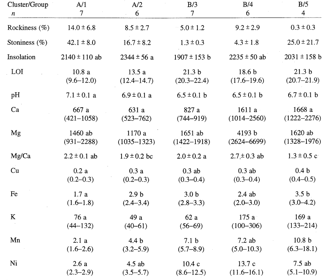
The main soil features of the vegetation groups of inland areas (Tab. 7) showed a picture similar to that reported for the Mediterranean areas. The plot groups in the inland data-set did not represent a natural succession, as those of the Mediterranean data-set, but included anthropogenically induced vegetation, such as the pine-dominated communities. Despite all this, pH, organic matter content, and metal availability were correlated with vegetation cover and structure, implying that the soil under garigue and scrub vegetation may be transformed by the growth of forests, such as invading pine trees.
内陆区域各植被组的主要土壤特征(表7)呈现出与地中海区域相似的格局。与地中海数据集不同,内陆数据集中的样方组并不代表自然演替序列,而是包含了人为诱导形成的植被,如以松树为优势的群落。尽管如此,pH、有机质含量和金属有效性仍与植被盖度和结构相关,这意味着加里格和灌丛植被下的土壤可能因森林(如入侵的松树)的生长而发生转变。
Gradient analysis梯度分析
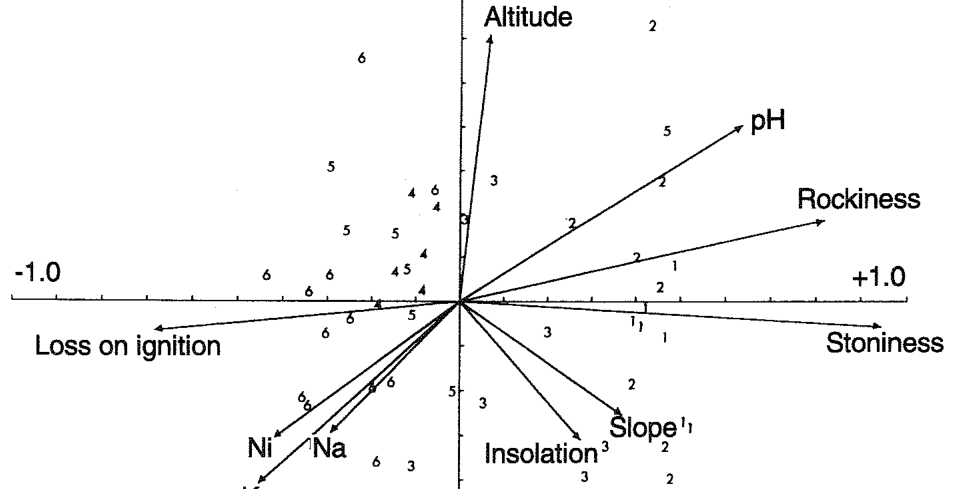
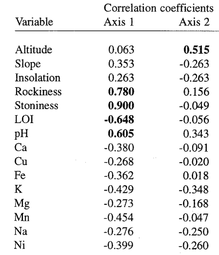
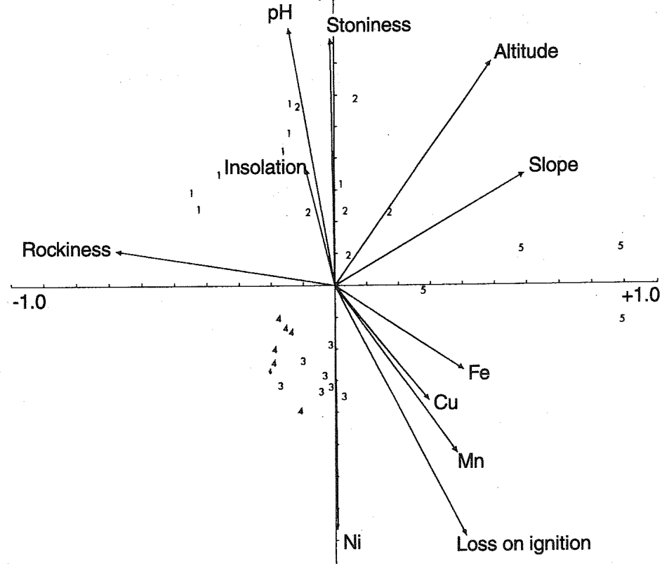
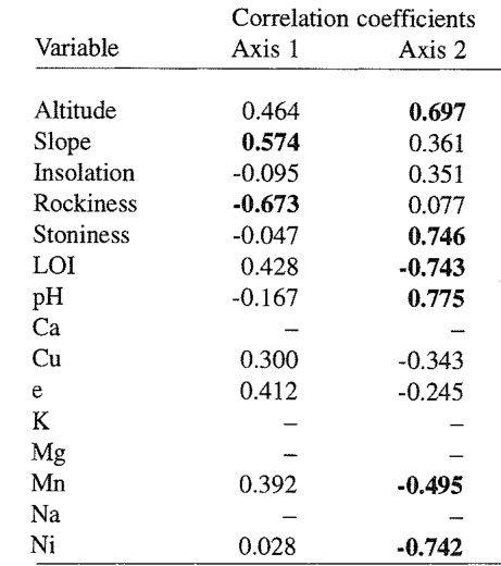
The CCA ordering of plots and environmental variables is shown in Fig. 3. The cumulative percentage of variance accounted by the first two axes was 35.4% (19.1% and 16.3%) of the species data and 48.9% (26.3% and 22.6%) of the species-environment relationships (Fig. 3). The eigenvalue of the first canonical axis was highly significant (P < 0.01). The first axis, which differentiated the woods of Group 5 with respect to other vegetation groups, was correlated positively with slope and negatively with rockiness. The second axis, which differentiated (a) Groups 3 and 4, (b) Group 5 and (c) Groups 1 and 2, was positively correlated with altitude, stoniness and pH, and negatively with organic matter, Mn and Ni content of the soil (Tab. 8).
样方与环境变量的CCA排序结果见图3。前两轴累计解释了物种数据方差的35.4%(分别为19.1%和16.3%)以及物种-环境关系的48.9%(分别为26.3%和22.6%)(图3)。第一典范轴的特征值极显著(P < 0.01)。第一轴将第5组林地与其他植被组区分开来,与坡度呈正相关,与岩石裸露率呈负相关。第二轴区分了(a)第3组和第4组、(b)第5组以及(c)第1组和第2组,与海拔、砾石率和pH呈正相关,与土壤有机质、Mn和Ni含量呈负相关(表8)。
4DISCUSSION讨论
The results indicate that the exchangeable fraction of soil metals was higher under the more evolved and structured communities, in both natural and anthropogenic environments, suggesting that soil metal content is not the most important limiting factor for the vegetation of Tuscan ultramafic soils. The soluble fraction of chromium was, in any case, too small to affect the vegetation (BROOKS 1987, PANDOLFINI & PANCARO 1992, ROBINSON et al. 1996). The increased availability of metals in the soil under the more evolved vegetation types may be a direct consequence of the lower pH. RoBINsoN et al. (1996) showed that metal solubility in New Zealand serpentines increased exponentially as the pH of the extracting solution was lowered. The effect of closed woody vegetation on soil may be to lower the pH by humic decay under moist conditions and therefore induce a higher availability of metals. The hypothesis that metal content is not the most important limiting factor causing the infertility of Tuscan serpentine soils was recently advanced in pedological (ANGELONE et al. 1991, 1993) and vegetation (CHIARUCCI & DE DOMINICIS 1995, CHIARUCCI 1996, CHIARUCCIet al. 1998) studies. The results of these studies were at variance with previous reports, and these authors emphasised the importance of the metal fraction available to plants as opposed to total metal concentrations.
结果表明,无论在自然还是人为环境中,发育程度更高、结构更完善的群落下土壤金属可交换态含量均更高,这说明土壤金属含量并非托斯卡纳超基性土壤植被最重要的限制因子。无论如何,铬的可溶态含量过低,不足以影响植被(BROOKS 1987, PANDOLFINI & PANCARO 1992, ROBINSON et al. 1996)。发育程度较高的植被类型下土壤金属有效性增加,可能是pH较低的直接结果。RoBINsoN et al.(1996)表明,新西兰蛇纹岩土壤中金属的溶解度随提取液pH的降低呈指数增长。郁闭木本植被对土壤的作用可能在于:在湿润条件下通过腐殖质分解降低pH,从而提高金属的有效性。金属含量并非导致托斯卡纳蛇纹岩土壤贫瘠的最重要限制因子这一假说,近期已在土壤学(ANGELONE et al. 1991, 1993)和植被学(CHIARUCCI & DE DOMINICIS 1995, CHIARUCCI 1996, CHIARUCCIet al. 1998)研究中被提出。这些研究的结果与以往报道不一致,其作者强调了对植物有效的金属组分相对于金属全量的重要性。
Many other authors claim that soil metal toxicity is not the most important limiting factor for serpentine vegetation. CARTER et al. (1987) did not find any evidence that nickel was the cause of the serpentine infertility in the keen of Hamar, Shetland Islands. KRUCKEBERG (1992) did not find any evidence that cobalt, chromium, iron and nickel affect plant growth in the ultramafic soils of western North America. In New Zealand, LEE (1992) observed that only in some southern ultramafics is nickel likely to reduce plant growth. In a review, PROCTOR & NAGY (1992) stated that many assumptions about causal roles for nickel in causing the unusual serpentine vegetation are unfounded and in-depth studies have often disproved the importance of this element.
许多其他作者也认为,土壤金属毒性并非蛇纹岩植被最重要的限制因子。CARTER et al.(1987)未发现任何证据表明镍是设得兰群岛Keen of Hamar蛇纹岩土壤贫瘠的原因。KRUCKEBERG(1992)未发现任何证据表明钴、铬、铁和镍影响北美西部超基性土壤上的植物生长。在新西兰,LEE(1992)观察到仅在南部部分超基性土壤中镍可能抑制植物生长。PROCTOR & NAGY(1992)在一篇综述中指出,许多关于镍导致蛇纹岩植被异常的因果作用的假设缺乏依据,深入研究往往否定了该元素的重要性。
One of the most important factors controlling the vegetation of Tuscan ultramafic soils appears to be drought stress due to topographical position. In both Mediterranean and inland sites, the insolation of juniper scrub communities, a relatively undisturbed vegetation type where the serpentine endemics are found, was significantly higher than that of the sites with a woodland vegetation cover. The index used in the present survey indicates the hours per year of overhead sunlight to give the radiation the site actually receives in one year, given its aspect, slope, and latitude, but the differences between sites might also be more important if considering summer drought. Water stress, together with soil nutritional deficiencies, constantly limits vegetation development. Periodic drought and other exceptional stresses may kill off the forest species, interrupting vegetation dynamics and thereby causing reversion to stunted and open plant communities and promoting soil erosion. For the serpentine soils of the Keen of Hamar, Shetland Islands, where rainfall is abundant throughout the year, CARTER et al. (1987) suggested that summer droughts of seven or more consecutive days, which happen on average once every 3-5 years, may exhaust the water reserves of the soil. This leads to the development of xerophilous, mainly annual, plant communities even in the humid oceanic climatic zone.
控制托斯卡纳超基性土壤植被的最重要因子之一似乎是地形位置所导致的干旱胁迫。在地中海和内陆样地中,刺柏灌丛群落(一种受干扰相对较少、分布有蛇纹岩特有种的植被类型)的日照均显著高于林地植被覆盖的样地。本研究所用指数以每年直射日照时数表示样地在给定坡向、坡度和纬度条件下一年内实际接收的辐射量,但若考虑夏季干旱,样地之间的差异可能更为重要。水分胁迫与土壤养分缺乏共同持续限制着植被的发育。周期性干旱及其他异常胁迫可能导致森林物种死亡,中断植被动态,从而使植被退回到矮小、开放的植物群落,并促进土壤侵蚀。对于全年降水充沛的设得兰群岛Keen of Hamar蛇纹岩土壤,CARTER et al.(1987)认为,平均每3~5年发生一次的连续7天或以上的夏季干旱,可能耗尽土壤中的水分储备。这导致即使在湿润的海洋性气候区,也会发育出以一年生植物为主的旱生植物群落。
There is now also strong evidence that nutrient availability is another important factor limiting plant growth and hence vegetation development in Tuscan ultramafic soils. The lower pH under woody plant communities not only increases the availability of plant nutrients such as K, Zn, Cu, Fe, but also facilitates their uptake. The N and P available (not measured) under maquis and woodland vegetation types are greater because of the higher organic matter content. Some recent studies showed that the addition of small amounts of nitrogen, phosphorus and potassium to garigue vegetation induced a strong increase in ground cover and biomass (CHIARUCCI et al., unpubl. data). Higher nutrient availability has also been reported to alleviate the effects of drought (GRIME & CURTIS 1976). PROCTOR & NAGY (1992) considered the low nutrient content of the soil a "key feature" in causing serpentine infertility in many areas. On the other hand, Ca-deficiency or the Mg/Ca ratio, considered very important limiting factors for serpentine vegetation (BROOKS 1987, BAKER et al. 1992, ROBERTS & PROCTOR 1992), did not appear as very important in these ultramafic soils. In fact the addition of calcium, alone or with nitrogen, phosphorus and potassium (NPK), led to a non-significant increase of cover and biomass with respect to controls and NPK alone (CHIARUccI et al. unpubl. data). This was probably due to the fact that in these soils the Mg/Ca quotient is relatively low, averaging 1.5 to 3.0.
目前亦有有力证据表明,养分有效性是限制托斯卡纳超基性土壤上植物生长进而限制植被发育的另一重要因子。木本植物群落下较低的pH不仅提高了K、Zn、Cu、Fe等植物养分的有效性,还促进了植物对它们的吸收。由于有机质含量较高,马基斯和林地植被类型下有效N和P(未测定)含量更高。近期一些研究表明,向加里格植被添加少量氮、磷和钾可显著提高地面盖度和生物量(CHIARUCCI et al., 未发表数据)。亦有报道指出,较高的养分有效性可缓解干旱的影响(GRIME & CURTIS 1976)。PROCTOR & NAGY(1992)认为,土壤养分含量低是许多地区蛇纹岩土壤贫瘠的“关键特征”。另一方面,被认为是蛇纹岩植被极为重要限制因子的缺钙或Mg/Ca比值(BROOKS 1987, BAKER et al. 1992, ROBERTS & PROCTOR 1992),在这些超基性土壤中似乎并不十分重要。实际上,单独添加钙或与氮、磷、钾(NPK)同时添加,与对照及单独添加NPK相比,盖度和生物量的增加均不显著(CHIARUccI et al. 未发表数据)。这可能是由于这些土壤的Mg/Ca比值相对较低,平均为1.5~3.0。
The development of more-structured woody communities positively improves soil structure and fertility, allowing a better plant growth by positive feedback. The natural dynamics towards more evolved vegetation types lead to the disappearance of the endemic species, linked to the less evolved soils, and the spread of the more competitive forest species. This implies that the persistence of garigue and open scrub vegetation, in which the serpentine endemics grow (PICHI SERMOLLI 1948, PIGNATTI 1982, ARRIGONI et al. 1983, CHIARUCCI et al. 1995), might require periodic disturbance or a factor that limits vegetation dynamics. Although specific data are not available, it can be inferred that forest fires are not rare, especially in the Mediterranean sites, but normally do not result in reversion to garigue vegetation. Likewise, anthropogenic disturbance over the last 3000-5000 years would have been insufficient for the evolution of serpentine endemic species such as the endemic nickel hyperaccumulator Alyssum bertolonii. Unlike the open juniper scrubs, the garigues of the Armerio-Alyssetum bertolonii association are not always located in areas with less favourable ecological conditions, such as xeric slopes. In addition, soils under the garigue plant communities show the lowest concentrations of potentially toxic metals. The lack of correlation between environmental limiting factors and garigue vegetation suggests that the spread of garigues has been partially favoured by human activity through destruction of more evolved vegetation types, such as the juniper scrub communities and the evergreen maquis.
结构更完善的木本群落的发育能够积极改善土壤结构和肥力,并通过正反馈使植物生长得更好。向发育程度更高的植被类型演替的自然动态,导致与发育程度较低的土壤相关联的特有种消失,而竞争力更强的森林物种则扩散开来。这意味着,蛇纹岩特有种赖以生长的加里格和开放灌丛植被(PICHI SERMOLLI 1948, PIGNATTI 1982, ARRIGONI et al. 1983, CHIARUCCI et al. 1995)的持续存在,可能需要周期性干扰或某种限制植被动态的因子。尽管缺乏具体数据,但可以推断森林火灾并不罕见,尤其是在地中海样地,但通常不会导致植被退回到加里格群落。同样,过去3000~5000年间的人为干扰也不足以使诸如特有镍超富集植物Alyssum bertolonii这样的蛇纹岩特有种得以进化形成。与开放刺柏灌丛不同,Armerio-Alyssetum bertolonii群丛的加里格群落并不总是位于生态条件较不利的区域(如干旱坡面)。此外,加里格植物群落下的土壤潜在有毒金属浓度最低。环境限制因子与加里格植被之间缺乏相关性,表明人类活动通过破坏刺柏灌丛群落和常绿马基斯群落等发育程度较高的植被类型,在一定程度上促进了加里格群落的扩展。
According to this picture, the Juniperus oxycedrus subsp. oxycedrus scrub communities are the most natural vegetation type on xeric slopes and their successional dynamics, towards closed and structured woodland communities, is prevented by nutrient deficiency and periodic reversion due to special stress factors such as drought. As is known for other environments (GRIME 1990, VAN DER MAAREL 1996), these droughts may be the driving force for the serpentine vegetation of Tuscany, creating gaps for new species to occupy. Xerophilous and heliophilous plants, such as the serpentine endemic Alyssum bertolonii, find optimal ecological conditions in open patches between shrubs. During evolutionary time, soil metals might have induced a selective pressure on plant populations growing in these patches, where the low-nutrient content of the soil and the drought stress cannot alleviate metal toxicity, allowing the selection of specialised taxa. True forest communities, on the other hand, can only be found in more favourable topographic conditions, where water stress is lower, exceptional droughts are less frequent and soil can accumulate. Long-term monitoring of permanent plots can test this hypothesis.
据此推断,Juniperus oxycedrus subsp. oxycedrus灌丛群落是干旱坡面上最自然的植被类型,其向郁闭、结构完善的林地群落演替的动态过程,受到养分缺乏以及干旱等特殊胁迫因子所引起的周期性退化的阻碍。正如在其他环境中已知的那样(GRIME 1990, VAN DER MAAREL 1996),这些干旱可能是托斯卡纳蛇纹岩植被的驱动力,为新物种的定居创造空隙。旱生和喜光植物(如蛇纹岩特有种Alyssum bertolonii)在灌木之间的开放斑块中获得最适宜的生态条件。在进化历程中,土壤金属可能对生长于这些斑块中的植物种群施加了选择压力——在这些斑块中,土壤低养分含量和干旱胁迫无法缓解金属毒性——从而使特化类群得以被选择。另一方面,真正的森林群落仅见于地形条件较为有利、水分胁迫较低、异常干旱较少发生且土壤得以积累的地方。对固定样方的长期监测可以检验这一假说。
Acknowledgement: The authors acknowledge Dr. Bruno Foggi, Dr. Ettore Putorti, Mr. Vincenzo Gonnelli and Mr. Davide Morrocchi for help during field sampling in the different areas. They also thank Dr. Ermanno Busoni for providing data on the index of normalised insolation, Dr. Claudia Angiolini, Dr. Simona Maccherini, and three anonymous referees for critical observations on the text.
致谢:作者感谢Bruno Foggi博士、Ettore Putorti博士、Vincenzo Gonnelli先生和Davide Morrocchi先生在各区域野外采样中给予的帮助。同时感谢Ermanno Busoni博士提供标准化日照指数数据,以及Claudia Angiolini博士、Simona Maccherini博士和三位匿名审稿人对本文提出的批评性意见。
5REFERENCES参考文献
ANGELONE M., VASELLIO., BINI C. & CORADOSSI N. (1993): Pedogeochemical evolution and trace elements availability to plants in ophiolitic soils. Sci. Total Environm. 129: 291-309.
ANGELONE M., VASELLI O., BINI C., CORADOSSI N. & PANCANI M.G. (1991): Total and EDTA-extractable element contents in ophiolitic soils from Tuscany (Italy). Z. Pflanzenernähr. Bodenk. 154: 217-223.
ARRIGONI P.V. (1980): Aspetti corologici della flora sarda (Chorological aspects of the Sardinian flora). Lav. Soc. Ital. Biogeogr. 8: 83-109.
ARRIGONI P. RICCERI RICCERIC. & MAZZANTI A. (1983): La vegetazione serpentinicola del Monte Ferrato di Prato in Toscana (The serpentinicolous vegetation of the Monte Ferrato in Tuscany). Centro di Scienze Naturali,
BAKER A.J.M., PROCTOR J. & REEVES R.D. (eds.) (1992): The vegetation of ultramafic (serpentine) soils. Intercept, Andover.
BARTORELLI U. (1967): Tavole numeriche dell'assolazione annua (Numerical tables of annual insolation). Ann. Accad. Ital. Sci. Forest. 16: 61-83.
BROOKS R.R. (1987): Serpentine and its vegetation. A multidisciplinary approach. Dioscorides, Portland.
CARTER S.P., PROCTOR J. & SLINGSBY D.R. (1987): Soil and vegetation of the Keen of Hamar serpentine, Shetland. J. Ecol. 75: 21-42.
CHIARUCCI A. (1994): Successional pathway of Mediterranean ultramafic vegetation in central Italy. Acta Bot. Croat. 53: 83-94.
CHIARUCCI A. (1996): Species diversity in plant communities on ultramafic soils in relation to pine afforestation. J. Veg. Sci. 7: 57-62.
CHIARUCCI A. & DE DOMINICIS V. (1995): Effects of pine plantations on ultramafic vegetation of central Italy. Israel J. Pl. Sci. 43: 7-20.
CHIARUCCI A., FOGGI B. & SELVI F. (1995): Garigue plant communities of ultramafic outcrops of Tuscany (Italy). Webbia 49: 179-192.
CHIARUCCI A., RICCUCCI M., CELESTI C. & DE DOMINICIS V. (1998): Vegetation-environment relationships in the ultramafic area of Monte Ferrato, Italy. Israel J. Pl. Sci. 46: (in press).
GRIME J.P. (1990): Mechanisms promoting floristic diversity in calcareous grasslands. In: HILLIER S.H., WALTON D.W.H. & WELLS D.A. (eds.), Calcareous grasslands: ecology and management, Bluntisham Books, Bluntisham, pp. 51-56.
GRIMEJ.P. & CURTIS A.V. (1976): The interaction of drought and mineral nutrient stress in calcareous grasslands. J. Ecol. 64: 975-998.
KRUCKEBERG A.R. (1992): Plant life of western North American ultramafics. In: ROBERTS B.A. & PROCTOR J. (eds.), The ecology of areas with serpentinized rocks, A world view, Kluwer, Dordrecht, pp. 31-74. LEE W.G. (1992): The serpentinized areas of New Zealand, their structure and ecology. In: ROBERTS B.A. & PROCTOR J. (eds.). The ecology of areas with serpentinized rocks, A world view, Kluwer, Dordrecht, pp.
MARCHIORI S. & TORNADORE MARCHIORI N. (1977): Lineamenti vegetazionali del Monte Pelato - Castiglioncello (Livorno) (Vegetational aspects of the Monte Pelato - Castiglioncello (Livorno)). Atti Soc. Tosc. Sci. Nat. Pisa Mem., Ser. B. 84: 7-15.
MESSERI A. (1936): Ricerche sulla vegetazione dei dintorni di Firenze. IV. La vegetazione delle rocce ofiolitiche del Monte Ferrato (presso Prato) (Research on the vegetation of the surroundings of Florence. IV. The vegetation of the ophiolitic rocks of Monte Ferrato (near Prato)). Nuovo Giorn. Bot. Ital. NS. 43: 277-372. MORALDO B. (1986): Il genere Stipa (L.) in Italia (The genus Stipa in Italy). Webbia 40: 203-278. PANDOLFINI T. & PANCARO L. (1992): Biogeochemical survey of some ophiolitic outcrops in Tuscany. Flora 187: 341-351.
PICHI SERMOLLI R. (1948): Flora e vegetazione delle serpentine e delle altre ofioliti dell'Alta valle del Tevere (Toscana) (Flora and vegetation of the serpentinites and other ophiolites of the Upper Tiber Valley (Tuscany)). Webbia 6: 1-380.
PIGNATTI S. (1982): Flora d'Italia (Flora of Italy). 1-3. Edagricole, Bologna.
PODANI J. (1993): SYN-TAX version 5.0. User's guide. Scientia, Budapest.
PODANI J. (1994): Multivariate data analysis in ecology and systematics. A methodological guide to the SYN-TAX 5.0 package. SPB Academic Publ., The Hague.
PROCTOR J. & NAGY L. (1992): Ultramafic rocks and their vegetation: an overview. In: BAKER A.J.M., PROCTOR J. & REEVES R.D. (eds.), The vegetation of ultramafic (serpentine) soils, Intercept, Andover, pp.
ROBERTS B.A. & PROCTOR J. (1992): The ecology of areas with serpentinized rocks. A world view. Kluwer,
ROBINSON B.H., BROOKS R.R., KIRKMAN J.H., GREGG P.E.H. & GREMIGNI P. (1996): Plant-available elements in soils and their influence on the vegetation over ultramafic ("serpentine") rocks in New Zealand. J. Roy. Soc. New Zealand 26: 455-466.
SASSE F. (1979a): Untersuchungen an Serpentinstandorten in Frankreich, Italien, Osterreich und der Bundesrepublik Deutschland. I. Bodenanalysen. Flora 168: 379-395.
SASSE F. (1979b): Untersuchungen an Serpentinstandorten in Frankreich, Italien, Österreich und der Bundesrepublik Deutschland. II. Pflanzenanalysen. Flora 168: 578-594.
TER BRAAK C.J.F. (1986): Canonical correspondence analysis: a new eigenvector technique for multivariate direct gradient analysis. Ecology 67: 1167-1179.
TER BRAAK C.J.F. (1988): CANOCO. A FORTRAN program for canonical community ordination by [partial] [detrended] [canonical] correspondence analysis, principal component analysis and redundancy analysis (Version 2.1). Upgrade to version 3.1. GLW, Wageningen.
VAN DER MAAREL E. (1996): Vegetation dynamics and dynamic vegetation science. Acta Bot. Neerl. 45: 421-442.
VERGNANO GAMBI O. (1992): The distribution and ecology of the vegetation of ultramafic soils of Italy. In: ROBERTS B.A. & PROCTOR J. (eds.), The ecology of areas with serpentinized rocks, A world view, Kluwer, Dordrecht, pp. 217-247.
Received 14 April 1997, revision received 5 January 1998, accepted 19 January 1998