Contents lists available at ScienceDirect
Catena
journal homepage: www.elsevier.com/locate/catena
Scott Sharp-Heward ⁎, Peter Almond, Brett Robinson
Lincoln University, Department of Soil and Physical Sciences, Canterbury, New Zealand
1Introduction引言
Anthropogenic landscape alteration is largely attributed to increases in agricultural production (Certini and Scalenghe, 2011; Ruddiman and Ellis, 2009). Widespread anthropogenic soils, defined as “soils that have been made by the direct action of people…” (Hewitt, 2010), have been found and dated commonly to c.2000 years and up to c.5000 years before present (Certini and Scalenghe, 2011). It is now recognised that mankind's imprint on the pedosphere has been profound, and owing to the heterogeneous nature of anthropogenic soil alteration, this area of study is one of the next major fields of soil science to be explored (Richter, 2007). Soil disturbance due to increased intensification of viticulture has been described in many northern Mediterranean countries such as Spain, Portugal, France, Italy, and Greece (Kosmas et al., 1997; Ramos et al., 2007). Recent (post 2000) vineyard establishment in NE Spain has involved land levelling and associated terracing work which has been carried out to increase site suitability for mechanisation (Ramos and Martínez-Casasnovas, 2007).
人为景观改变主要归因于农业生产的增长(Certini and Scalenghe, 2011; Ruddiman and Ellis, 2009)。人为土壤被定义为“由人类直接活动形成的土壤……”(Hewitt, 2010),此类土壤分布广泛,其年代通常可追溯至距今约2000年,最早可达距今约5000年(Certini and Scalenghe, 2011)。目前已认识到,人类对土壤圈的影响十分深远;由于人为土壤改变具有异质性,该领域已成为土壤科学下一个有待探索的重要研究方向之一(Richter, 2007)。在西班牙、葡萄牙、法国、意大利和希腊等许多地中海北部国家,葡萄种植集约化程度的提高所导致的土壤扰动已有报道(Kosmas et al., 1997; Ramos et al., 2007)。西班牙东北部近期(2000年以后)的葡萄园建设涉及土地平整及相关的梯田修筑工程,其目的在于提高场地对机械化作业的适宜性(Ramos and Martínez-Casasnovas, 2007)。
The earthwork processes required to carry this work out have resulted in topsoil layers being removed, mixed, or buried in deeper soil horizons. Resulting soils were low in organic matter, had weak structural properties, and high susceptibility to sealing (Ramos et al., 2000). Related studies have found that soil sealing causes negative effects on the erosion on similar sites (Meyer and Martınez-Casasnovas, 1999; Ramoś et al., 2000; Singer and Le Bissonnais, 1998). Deterioration of soil properties such as organic matter, hydraulic conductivity, water retention, and aggregate stability has been reported as a result of vineyard terracing in Spain (Ramos et al., 2007).
实施上述工程所需的土方作业导致表土层被剥离、混合或埋入较深的土层。由此形成的土壤有机质含量低、结构性差,且极易发生表面结皮(Ramos et al., 2000)。相关研究发现,土壤结皮会加剧类似场地的侵蚀(Meyer and Martınez-Casasnovas, 1999; Ramoś et al., 2000; Singer and Le Bissonnais, 1998)。据报道,西班牙葡萄园梯田修筑导致土壤有机质、导水率、持水性和团聚体稳定性等性质退化(Ramos et al., 2007)。
⁎ Corresponding author at: Department of Soil and Physical Sciences, Lincoln University, Lincoln 7647, Christchurch, New Zealand.
⁎ 通讯作者:Department of Soil and Physical Sciences, Lincoln University, Lincoln 7647, 基督城,新西兰。
E-mail addresses: scott.sharp-heward@lincolnuni.ac.nz (S. Sharp-Heward), peter.almond@lincoln.ac.nz (P. Almond), brett.robinson@lincoln.ac.nz (B. Robinson).
The wine industry in New Zealand has grown significantly over the period of 2000–2010 (wineinf.nzwine.com/statistics). The Marlborough region is situated in the north-east South Island of New Zealand and was one of the regions of major viticultural expansion. The region now hosts in excess of 20,000 ha of grape vines dedicated to wine production. Easily-planted valley floors were the first locations to have vineyards established in this region. Many of these plantings occurred during a period of increasing grape prices (statistics from nzwine.com). As land on valley floors became scarce and expensive, it became more economically viable to plant vineyards on rolling hills adjacent to the river floodplains. To make vineyard establishment easier on these hills, especially with regard to mechanisation, an earthwork process known as recontouring was commonly employed. This process commonly utilised a ‘double stripping’ technique similar to that used in some aluminium mining operations (Koch, 2007). Double stripping typically involved scraping and collection of topsoil and the upper 30 cm of subsoil into separate piles, followed by recontouring of any remaining subsoil and the underlying bedrock to achieve a lower slope gradient. The piles were then re-spread into an ersatz soil profile over the recontoured landscape. Topsoil residence in piles has been shown to temporarily decrease soil microbial abundance and alter population structure (Banning et al., 2008; Harris and Birch, 1989), in addition to changes to soil physical properties such as amount of large aggregates (which decrease) (Schäffer et al., 2007). The aesthetic impacts of recontouring on the vista of the landscape is recognised globally (Daniel, 2001; Hunziker and Kienast, 1999), but has not been addressed in the scope of this work.
2000—2010年间,新西兰葡萄酒产业显著增长(wineinf.nzwine.com/statistics)。马尔堡(Marlborough)地区位于新西兰南岛东北部,是葡萄种植大规模扩张的主要地区之一。该地区目前用于酿酒的葡萄种植面积已超过20,000 ha。易于种植的谷底平地是该地区最早建立葡萄园的地点,其中许多种植发生在葡萄价格上涨时期(统计数据来自nzwine.com)。随着谷底土地日益稀缺和昂贵,在毗邻河漫滩的起伏丘陵上种植葡萄在经济上变得更为可行。为便于在这些丘陵上建立葡萄园,尤其是便于机械化作业,普遍采用了一种称为地形重塑(recontouring)的土方工艺。该工艺通常采用一种类似于某些铝土矿开采作业中使用的“双重剥离”技术(Koch, 2007)。双重剥离通常包括将表土和上部30 cm心土分别刮取并堆放成不同的土堆,随后对剩余心土及下伏基岩进行重塑,以降低坡度。之后将土堆重新摊铺于重塑后的地形上,形成人造土壤剖面。研究表明,表土在堆存期间会暂时降低土壤微生物丰度并改变其群落结构(Banning et al., 2008; Harris and Birch, 1989),同时还会改变土壤物理性质,例如大团聚体数量减少(Schäffer et al., 2007)。地形重塑对景观视觉的美学影响已在全球范围内得到认识(Daniel, 2001; Hunziker and Kienast, 1999),但不在本研究范围之内。
http://dx.doi.org/10.1016/j.catena.2014.06.022 0341-8162/© 2014 Elsevier B.V. All rights reserved.
http://dx.doi.org/10.1016/j.catena.2014.06.022 0341-8162/© 2014 Elsevier B.V. 版权所有。
The aim of this study was to investigate whether or not the recontouring process has led to the deterioration of soil quality on a hilly vineyard site in Marlborough, New Zealand. We hypothesised that (I) stripping, stockpiling, and respreading of topsoil would result in loss of organic C, and (II) that mixing of sodic subsoils and saline bedrock into subsoils would lead to enhanced sodicity and salinity. The objectives of the study aimed at testing these hypotheses were: (i) characterising the effects of recontouring on soil morphology and chemistry; (ii) quantifying and comparing profile masses of organic C and N between recontoured and virgin areas; and (iii) quantifying the enhancement of salinity in zones of drainage accumulation within soils and receiving waters.
本研究旨在探讨地形重塑过程是否导致新西兰马尔堡一处丘陵葡萄园场地的土壤质量退化。我们假设:(I)表土的剥离、堆存和重新摊铺会导致有机碳损失;(II)钠质心土和盐渍基岩混入心土会导致钠质化和盐渍化加剧。为检验上述假设,本研究的目标为:(i)表征地形重塑对土壤形态和化学性质的影响;(ii)定量并比较重塑区与原生区之间有机碳和氮的剖面储量;(iii)定量土壤内部排水汇集区及受纳水体中盐分的增加程度。
2Methodology研究方法
2.1. Study area and field characteristics2.1. 研究区概况与场地特征
The study site was located on a commercial vineyard in the Awatere Valley sub-region of the Marlborough region in New Zealand. The
研究场地位于新西兰马尔堡地区Awatere Valley子区域的一处商业葡萄园。
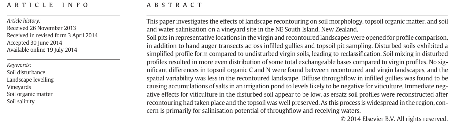
Awatere Valley in the north-east of New Zealand's South Island (see Fig. 1) occupies a fault-angled depression oriented northeast/southwest along the Awatere Fault, which is a component of thelarger Marlborough Fault System. This region is active tectonically as it is close to the convergence of the Australian and Pacific plates, and is characterised by high rates of crustal deformation and uplift (Rattenbury et al., 2006). The climate of the lower Awatere Valley is characterised by relatively high sunshine hours (2200 h/year) and a moderate rainfall (620 mm/year) which is distributed towards winter surplus and summer demand for irrigation (NIWA CliFlo, 2013). A scoping study recognised 18 different vineyard sites in the Awatere Valley that have been affected by recontouring (Lynn, 2009). One of these, the Hardcase vineyard, was selected for field work.
Awatere Valley位于新西兰南岛东北部(见图1),占据沿Awatere断层呈东北—西南走向的断层角洼地,该断层是更大的马尔堡断层系统的组成部分。该地区靠近澳大利亚板块与太平洋板块的汇聚带,构造活动活跃,地壳变形和抬升速率较高(Rattenbury et al., 2006)。Awatere Valley下游地区气候特征为日照时数较长(2200 h/year),降水量适中(620 mm/year),降水分布呈冬季盈余、夏季需灌溉的特点(NIWA CliFlo, 2013)。一项前期调查在Awatere Valley识别出18处受地形重塑影响的葡萄园场地(Lynn, 2009),其中Hardcase葡萄园被选为野外研究地点。
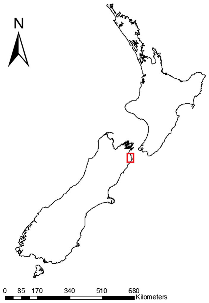
Hardcase vineyard comprises 34 ha planted in wine grapes, although the 18 ha highlighted in Fig. 2 identifies the recontoured study area only. The previous site vegetation was mixed dryland ryegrass (Lolium perenne)/browntop (Agrostis capillaris). The Hardcase property is within an erosional hilly landscape developed in the Miocene to late Pliocene Starborough Formation. This Formation comprises poorly bedded brownish-grey fossiliferous sandstone and sandy siltstone (Rattenbury et al., 2006). The main drainage network on the property is oriented south to north and terminates at the SW–NE trending Blind River to the north of the property. According to the New Zealand Soil Classification System (Hewitt, 2010), the soils on Hardcase vineyard are Argillic Sodic Fragic Pallic soils in the New Zealand Land Resource Inventory database (Landcare Research, 2013). Accessory properties of Pallic soils, some of which may be relevant to recontouring, include high slaking and dispersion, slow permeability (often due to dense subsurface layers), and a perched water table. Inclusion into the Argillic group of Pallic soils is on the basis of a clay-enriched B horizon with evident clay coatings on ped or pore surfaces. Inclusion into the Sodic subgroup results from sodic features (Exchangeable Sodium Percentage N 6%) in or beneath the Argillic horizon. Argillic Sodic Pallic soils, which this site is mapped as, equate to Typic Natrustalfs or Haplustalfs under the USDA Soil Taxonomy (Soil Survey Staff, 2010). Recontoured soils are not well accommodated by the USDA Soil Taxonomy, but key out to Typic Ustorthents. The vines on the studied section of this property were oriented E–W (south end) and N–S (northern block).
Hardcase葡萄园酿酒葡萄种植面积为34 ha,图2中标示的18 ha仅为地形重塑研究区。场地原有植被为旱作黑麦草(Lolium perenne)/细弱剪股颖(Agrostis capillaris)混合草地。Hardcase地产位于中新世至晚上新世Starborough组发育的侵蚀丘陵景观中。该组由层理不清的褐灰色含化石砂岩和砂质粉砂岩组成(Rattenbury et al., 2006)。地产内主要排水网络呈南北走向,终止于地产北部呈西南—东北走向的Blind River。根据新西兰土壤分类系统(Hewitt, 2010),新西兰土地资源清单数据库(Landcare Research, 2013)将Hardcase葡萄园土壤划为黏化钠质脆盘淡色土(Argillic Sodic Fragic Pallic soils)。淡色土的附属性质(其中部分可能与地形重塑相关)包括易崩解和分散、渗透性差(常因存在致密的表下层)以及存在上层滞水。将其归入淡色土的黏化土类,是依据存在黏粒富集的B层且结构体或孔隙表面有明显的黏粒胶膜;归入钠质亚类则是由于黏化层内或其下存在钠质特征(交换性钠百分率 > 6%)。本场地所划定的黏化钠质淡色土相当于美国农业部土壤系统分类(USDA Soil Taxonomy)中的典型钠质干润淋溶土(Typic Natrustalfs)或简育干润淋溶土(Haplustalfs)(Soil Survey Staff, 2010)。重塑土壤在美国农业部土壤系统分类中难以准确归类,但检索结果为典型干润正常新成土(Typic Ustorthents)。该地产研究区段的葡萄行向为东西向(南端)和南北向(北部地块)。
The recontouring sequence on this vineyard involved the scraping of topsoil and clay (subsoil) into piles, followed by subsequent ‘mining’ of clay and siltstone from ridge crests and its redistribution to gullies and other low points in the landscape. Subsequently, subsoil was added back to the recontoured land followed by the topsoil to reconstruct the soil. Before planting in grape vines the land was subsoiled (deepripped) to a depth of 800 mm. This work was carried out in the summer of 2007, followed immediately by vineyard establishment.
该葡萄园的地形重塑流程包括:先将表土和黏土(心土)刮取堆放,随后从山脊顶部“开采”黏土和粉砂岩,并将其重新分配至冲沟及景观中的其他低洼处。之后将心土回填至重塑后的土地上,再覆盖表土以重构土壤。种植葡萄前对土地进行深松(深耕)至800 mm深度。上述工程于2007年夏季实施,随即建立葡萄园。
2.2. Field sampling2.2. 野外采样
Soils were described as ‘disturbed’ if they were present in the recontoured landscape, whereas control soils were described as ‘virgin’ and occurred on undisturbed hillslopes on the property. Soil pits were excavated on lower and upper slope virgin and recontoured sites to 1–1.2 m depth, and were sampled on a horizon or depth (where horizonation was weak) basis for pH, TEB, and EC. The depth increment sampling basis typically proceeded in 20 or 30 cm increment depths. All pH and EC samples were analysed in duplicate. Soil morphology was described by the methods of Taylor and Pohlen (1962).
位于重塑景观中的土壤称为“扰动”土壤,而对照土壤称为“原生”土壤,分布于地产内未受扰动的山坡上。在原生和重塑场地的下坡和上坡位置开挖土壤剖面至1–1.2 m深度,按发生层或深度(发生层分异较弱时)采样,测定pH、交换性盐基总量(TEB)和电导率(EC)。按深度采样时通常以20或30 cm为间隔。所有pH和EC样品均进行重复测定。土壤形态按Taylor and Pohlen(1962)的方法描述。
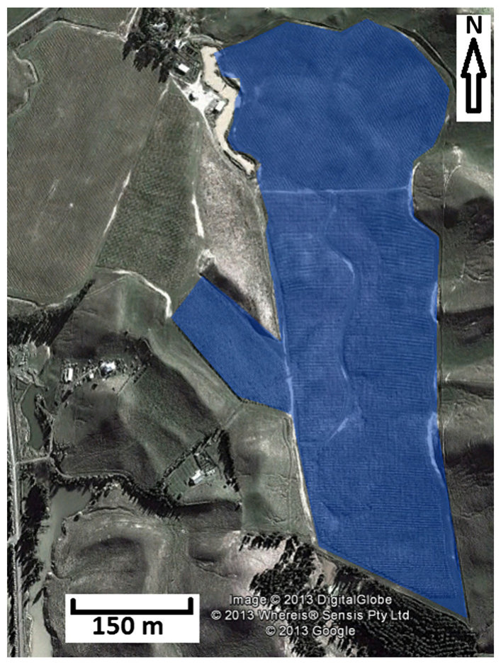
The effect of recontouring on topsoil thickness and quality (organic C and N %) was investigated by using sample transects. Six transects were aligned across ridge crests above the recontoured vineyard, and an additional six transects were established across the recontoured section of what was originally the same ridges (Fig. 3). Along each transect, five samples were taken in the sequence footslope–backslope–summit– backslope–footslope from one side of the ridge crest to the other. Sample separation was generally 20 m intra-transect. Slope transects therefore were roughly 100 m in length and consisted of two footslope pits, two midslope pits, and one summit pit per transect. The variation in this 20 m separation was due to differing distances between slope elements on different transects. Sampling involved digging a small pit to the bottom of the topsoil, recording topsoil depth, taking an intact core for bulk density determination, and collecting soil for the analysis of C and N concentrations. Topsoil C and N masses were calculated as follows: X = [x] h ρb ∗ 100, where X = C or N profile mass (g m−2), [x] = C or N concentration in %, h = topsoil thickness (cm), and ρb = topsoil bulk density in g cm−3.
采用采样样带研究地形重塑对表土厚度和质量(有机碳和氮含量,%)的影响。在重塑葡萄园上方的山脊顶部布设6条样带,另在原属同一山脊的重塑区段布设6条样带(图3)。沿每条样带,从山脊一侧至另一侧按坡麓—背坡—坡顶—背坡—坡麓的顺序采集5个样品。样带内采样间距一般为20 m,因此每条坡面样带长约100 m,包括2个坡麓样坑、2个坡腰样坑和1个坡顶样坑。20 m间距的变化源于不同样带上坡面单元间距离的差异。采样时挖掘小坑至表土底部,记录表土厚度,采集原状土芯用于测定容重,并采集土样分析碳和氮含量。表土碳和氮储量按下式计算:X = [x] h ρb ∗ 100,式中X为碳或氮剖面储量(g m−2),[x]为碳或氮含量(%),h为表土厚度(cm),ρb为表土容重(g cm−3)。
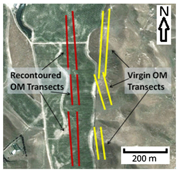
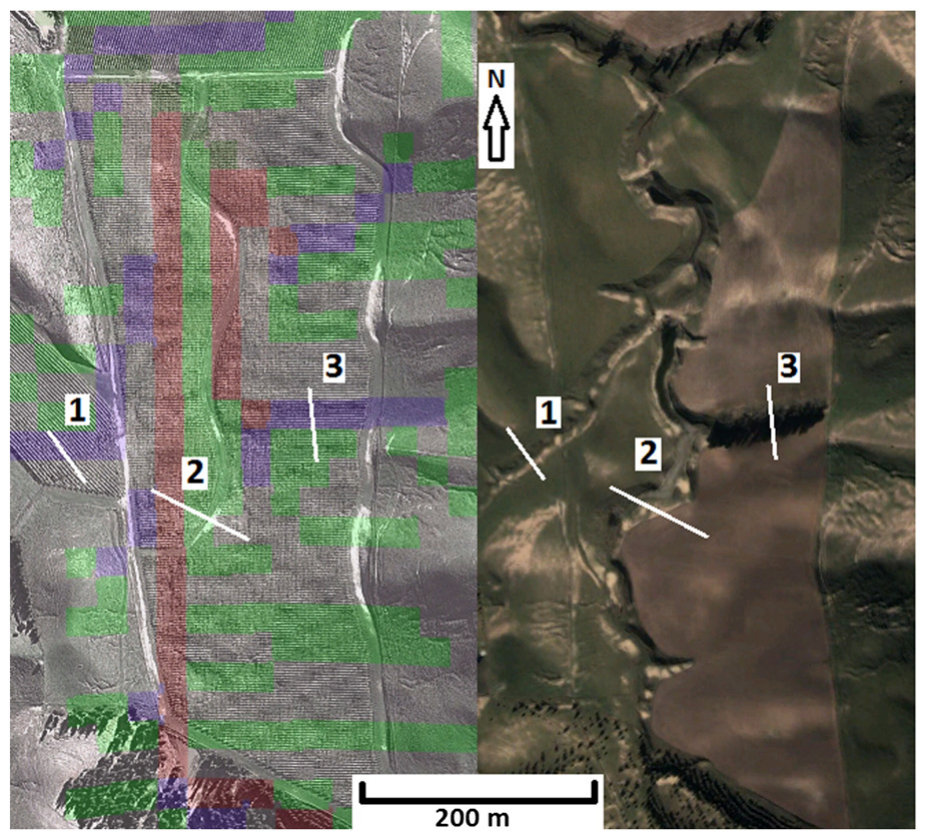
Examination of a pre-recontouring satellite site image (Fig. 4) indicates the previous drainage networks which may now route subsurface water and solutes as throughflow within gully fills. A transect sampling scheme was designed to identify remobilisation of salts along potential subsurface flow lines inherited from the pre-recontouring topography. Transect location and orientation were informed by conducting stream order analysis of a 25 m resolution digital elevation model of the study area in ArcMap 10 (ESRI, 2012), which captured pre-recontouring topography. Transects were aligned orthogonal to two infilled drainage gullies, hand augered at 10 m intervals, and sampled at 20–30, 40–50 and 70–80 cm depths and analysed for pH and EC. Transect 1 traversed an ephemeral (zero-order) drainage gully, identified by aerial photography pre-recontouring, whereas Transect 2 traversed what was the primary drainage gully. Transect 3 was carried out across a recontoured hillslope which had no pre-existing or current gully. Statistical analyses were carried out by selecting each auger as either ‘gully’ or ‘non-gully’ dependant on proximity (±10 m) to infilled gullies (based on pre-recontouring aerial photos). Mean values were obtained for each auger hole and analysed statistically as described below. Siltstone on this property was found to have a pH of 8.6 and EC of 660 μS/cm. All pH and EC samples were analysed in duplicate. Other techniques including remote sensing, proximal sensing, and modelling have been found to be useful in the prediction of soil surface hydrology and assessment of salt-affected soils but were not included in this work due to time constraints (Farifteh et al., 2006; Schmugge et al., 2002).
对地形重塑前的卫星影像(图4)的分析显示了原有排水网络,这些网络目前可能以冲沟填土内壤中流的形式输送地下水及溶质。为识别盐分沿继承自重塑前地形的潜在地下流路的再迁移,设计了样带采样方案。样带位置和方向依据在ArcMap 10(ESRI, 2012)中对研究区25 m分辨率数字高程模型(反映重塑前地形)进行的河流分级分析确定。样带垂直于两条已被填平的排水冲沟布设,每隔10 m人工钻孔,采集20–30、40–50和70–80 cm深度的样品,测定pH和EC。样带1横穿一条季节性(零级)排水冲沟(根据重塑前航空照片识别),样带2横穿原主排水冲沟,样带3布设于一处既无原有冲沟也无现有冲沟的重塑山坡。统计分析时,根据各钻孔与填平冲沟的距离(±10 m;依据重塑前航空照片)将其划分为“冲沟”或“非冲沟”。计算每个钻孔的平均值,并按下文所述方法进行统计分析。该地产粉砂岩的pH为8.6,EC为660 μS/cm。所有pH和EC样品均进行重复测定。遥感、近地传感和模型模拟等其他技术已被证明可用于预测土壤表面水文过程和评估盐渍土(Farifteh et al., 2006; Schmugge et al., 2002),但因时间限制本研究未予采用。
An irrigation pond formed by the damming of the main stream draining the vineyard was sampled for water chemistry. Samples were taken on a monthly basis by collection from the pond shore and frozen until analysis could take place. The irrigation pond would have been well mixed due to shallow (roughly 3–4 m) depth. Water samples were analysed for pH and EC as detailed below.
对拦蓄葡萄园主排水溪流而形成的灌溉池塘进行了水化学采样。每月从池塘岸边采集水样,冷冻保存至分析。由于水深较浅(约3–4 m),灌溉池塘水体应混合均匀。水样按下文所述方法测定pH和EC。
2.3. Laboratory analysis2.3. 实验室分析
Soil samples were air dried, crushed, and sieved (brass sieve) to b2 mm particle size (Theng, 1980), except for C and N analyses which were sieved to b63 μm. Total exchangeable bases were determined by the silver-thiourea soil extraction method (Theng, 1980). The extract was analysed using a Varian 720-ES Inductively Coupled Plasma Optical Emission Spectrophotometer fitted with an SPS-3 autosampler and ultrasonic nebuliser. Water samples for pH and EC were kept frozen until needed, upon which they were thawed and directly analysed on the equipment described below. Soil pH was measured in a soil:water extract (1:2.5) after a 20–24 h stabilisation period post water addition (Blakemore et al., 1987). Soil EC was measured in a soil:water extract (1:5) with a Mettler Toledo SevenEasy pH/EC Meter equipped with a Mettler-Toledo Inlab®730 conductivity probe calibrated to a 1412 μS/cm standard. A Mettler Toledo SevenEasy pH/EC Meter equipped with a Mettler Toledo Inlab®413 electrode was used to measure soil pH and EC. Organic C was analysed on the Elementar Vario- Max CN Elemental Analyser by the ‘Solid-TOC for elemental analyser vario MAX’ method (Elementar, 2013). Total N was analysed by an Alpkem FS3000 twin channel analyser following Kjeldahl digest of soil material. Post-digestion the samples were filtered (Whatman 52, hardened) before the analysis. Intact soil cores (5 cm diameter by 7.5 cm height) were taken at a rate of one per organic matter transect, dried at 100 °C for 24 h, and then weighed so that bulk density could be calculated.
土壤样品经风干、磨碎后过筛(黄铜筛)至粒径 < 2 mm(Theng, 1980),用于碳、氮分析的样品过 < 63 μm筛。交换性盐基总量采用硫脲银土壤浸提法测定(Theng, 1980)。浸提液采用配备SPS-3自动进样器和超声雾化器的Varian 720-ES电感耦合等离子体发射光谱仪分析。用于测定pH和EC的水样冷冻保存,使用前解冻后直接用下述仪器分析。土壤pH在土水比1:2.5的浸提液中加水后平衡20–24 h测定(Blakemore et al., 1987)。土壤EC在土水比1:5的浸提液中,采用配备Mettler-Toledo Inlab®730电导电极(以1412 μS/cm标准液校准)的Mettler Toledo SevenEasy pH/EC仪测定。土壤pH和EC采用配备Mettler Toledo Inlab®413电极的Mettler Toledo SevenEasy pH/EC仪测定。有机碳采用Elementar Vario- Max CN元素分析仪,按“Solid-TOC for elemental analyser vario MAX”方法测定(Elementar, 2013)。全氮经凯氏消解后采用Alpkem FS3000双通道分析仪测定,消解后样品经滤纸(Whatman 52,硬化型)过滤后分析。每条有机质样带采集1个原状土芯(直径5 cm × 高7.5 cm),于100 °C烘干24 h后称重,以计算容重。
2.4. Statistical analysis2.4. 统计分析
Organic C and N data were analysed statistically in two ways, firstly treating all samples as spatially uncorrelated and using analysis of variance (ANOVA), and secondly using geostatistical techniques (semivariance and semivariograms) to explore spatial autocorrelation. One-way ANOVA were carried out on organic C and N (as dependant variables) separately, for which sample site disturbance (virgin/ recontoured) was the independent variable. This was carried out in the statistical software package R (version 3.0.1). A series of four variograms were constructed in R (version 3.0.1) to examine the variability structure of the organic C and N data on both virgin and recontoured sites. This utilised the ‘gstat’ package for R (Pebesma, 2004). Data utilised for this analysis included XY coordinates in the New Zealand Transverse Mercator (NZTM) projection system and organic C and N values in units of mg organic C/N per profile.
有机碳和氮数据采用两种方法进行统计分析:一是将所有样品视为空间上不相关,采用方差分析(ANOVA);二是采用地统计学方法(半方差及半变异函数)探讨空间自相关性。分别以有机碳和氮为因变量、以采样点扰动状况(原生/重塑)为自变量进行单因素ANOVA,分析在统计软件R(3.0.1版)中完成。在R(3.0.1版)中构建4个变异函数,以考察原生和重塑场地有机碳和氮数据的变异结构,分析采用R的“gstat”程序包(Pebesma, 2004)。所用数据包括新西兰横轴墨卡托(NZTM)投影坐标系下的XY坐标及以每剖面有机碳/氮毫克数表示的有机碳和氮值。
Statistical analysis of the drainage transect data included ANOVA and Tukey's Honestly Significant Difference tests carried out in the R statistical package (version 3.0.1).
排水样带数据的统计分析包括ANOVA和Tukey真实显著差异检验,在R统计软件包(3.0.1版)中完成。
3Results and discussion结果与讨论
3.1. Soil morphology and chemistry3.1. 土壤形态与化学性质
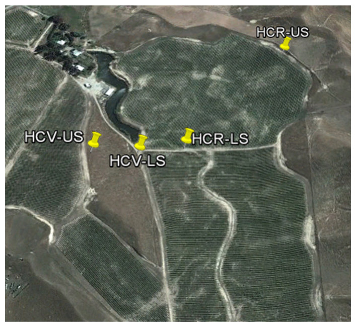
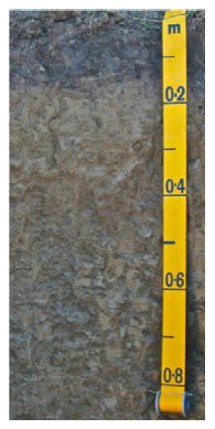
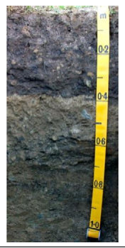
An example of the undisturbed soil on this property was exposed on an upper slope section proximal to but not in the vineyard (Fig. 5 for location, Table 2 for description). This soil (designated HCV-US), which is currently under pasture, exhibited a gradual texture change between the Silt Loam (SiL)/Clay Loam (CL) of the upper 25 cm of soil to the sticky and plastic clay of the lower 120 cm of profile. This transition occurred between the Bw and Bt horizons, the latter of which displayed some faint mottling, suggesting slight seasonal waterlogging at the top of the Argillic horizon. Plant rooting was not disturbed by this texture contrast and continued to the base of the profile. Strongly developed sub-angular blocky structure was present in both the Bt and C horizons, whereas the Ah and Bw horizons possessed that same type of structure but of only a moderate grade. The apparent strong structure described in the C horizon may be a relict of desiccation cracking or structure formed into the marine siltstone during the formation of the stone. Clasts were not present in this soil, or any of the following described soils.
该地产未扰动土壤的一个实例出露于葡萄园附近但位于园外的上坡区段(位置见图5,描述见表2)。该土壤(编号HCV-US)目前为牧场,其质地由上部25 cm的粉砂壤土(SiL)/黏壤土(CL)逐渐过渡到剖面下部120 cm的黏着、可塑性黏土。这一过渡发生在Bw层与Bt层之间,后者可见少量模糊的锈斑,表明黏化层顶部存在轻度季节性渍水。植物根系未受此质地差异的阻碍,一直延伸至剖面底部。Bt层和C层均具强发育的次棱块状结构,而Ah层和Bw层虽具相同类型结构,但发育程度仅为中等。C层中所描述的明显强结构可能是干裂的残留,或是海相粉砂岩在成岩过程中形成的结构。该土壤及下文描述的所有土壤中均未见碎屑。
In contrast to this profile, the recontoured upper slope soil (in grass sward between vine rows) exposed in pit HCR-US (Mixed Anthropic soil, Hewitt (2010)) showed a lack of natural soil horizonisation, instead showing a simple profile consisting of a mixed A horizon and a mixed B horizon (Table 2). The soil colours reflected a mixing of subsoil and siltstone into the A horizon, and similarly topsoil and siltstone occlusions were present within a matrix of B horizon. These horizons changed from a moderately developed sub-angular blocky structure with a clay loam texture in the topsoil to a massive clay subsoil. This profile trend of structure contrasts with the HCV-US soil, which possessed strong structure grade. The soil chemistry depth trends of this soil relative to HCV-US showed less variation in total exchangeable bases over the profile, higher pH, and no increase in EC and exchangeable Na with soil depth (Table 3). These differences highlight the reduction of horizon definition and profile differentiation in disturbed soils. (See Tables 4–6.)
与该剖面不同,在HCR-US样坑(混合人为土,Hewitt (2010))中出露的重塑上坡土壤(位于葡萄行间草带)缺乏自然的土壤发生层分异,仅表现为由混合A层和混合B层组成的简单剖面(表2)。土壤颜色反映了心土和粉砂岩混入A层,同样,B层基质中也夹杂有表土和粉砂岩包裹体。这些发生层由表土中等发育的次棱块状结构、黏壤土质地转变为心土的块状黏土。该剖面的结构变化趋势与具强结构等级的HCV-US土壤形成对比。与HCV-US相比,该土壤化学性质随深度的变化表现为交换性盐基总量在剖面中的变异较小、pH较高,且EC和交换性Na不随土壤深度增加(表3)。这些差异凸显了扰动土壤发生层界限和剖面分异程度的降低。(见表4–6。)
Soil profile morphology data for lower slope soil pits on Hardcase property.
Hardcase地产下坡土壤样坑的剖面形态数据。
| Horizon发生层 | Colour颜色 | Mottles锈斑 | Texture质地 | Clasts碎屑 | Consistence结持性 | Structure结构 | Cutans胶膜 | Roots根系 |
|---|---|---|---|---|---|---|---|---|
| Lower virgin slope soil p NZSC: Sodic Argillic Pall USDA soil tax.: typic Na | it (HCV-LS) 41° ic soil trustalf | 42′39.48″S 174° | 6′53.28″E | |||||
| Ah 0–17 cm, clear smooth boundary | 10 YR 4/2 | – | Silt loam | – | Slightly hard, slightly sticky, plastic | Moderate, medium, blocky | – | Common, veryfine |
| Bt1 17–34 cm, gradual smooth boundary | 2.5 YR 6/4 | – | Clay | – | Slightly hard, very sticky, plastic | Moderate, medium/ coarse, blocky | – | Few, very fine |
| Bt2 34-105+ cm | 10 YR 6/4 | Few,fine, distinct, 10 YR 5/6 | Clay | – | Very hard, very sticky, very plastic | Strong, moderate/ coarse, blocky | 3 p pf 10 YR 5/3 cutans | Few, very fine |
Lower recontoured slope soil pit (HCR-LS) 41°42′38.88″S 174° 6′56.82″E NZSC-mixed anthropic soil USDA soil tax.: typic Ustorthent
下部重塑坡面土壤样坑(HCR-LS)41°42′38.88″S 174° 6′56.82″E NZSC:混合人为土 USDA土壤系统分类:典型干润正常新成土(typic Ustorthent)

Key for morphology: Horizon (distinctness/shape); Mottles (quantity/size/contrast); Texture; Consistency (dry or moist/stickiness/plasticity); Structure (grade/size/type); Cutans (amount/distinctness/location); Roots (abundance/size). Key for classification: NZSC — New Zealand Soil Classification (Hewitt, 2010), USDA Soil Tax. — United States Department of Agriculture Soil Taxonomy (Soil Survey Staff, 2010).
形态描述说明:发生层(明显度/形状);锈斑(数量/大小/对比度);质地;结持性(干或湿/黏着性/可塑性);结构(等级/大小/类型);胶膜(数量/明显度/位置);根系(丰度/大小)。分类说明:NZSC——新西兰土壤分类(Hewitt, 2010);USDA Soil Tax.——美国农业部土壤系统分类(Soil Survey Staff, 2010)。
Lower on the slope to where HCV-US was exposed, the pit HCV-LS (Sodic Argillic Pallic soil) was opened as another control soil under pasture (Fig. 5 for location, Table 1 for description). This soil had similar morphology to the HCV-US soil, except that the textural contrast between the SiL topsoil and clay rich Argillic (Bt1, Bt2) horizons was sharp and did not transition through a CL-textured layer. The clay illuviation evident in the HCV-LS was strongly expressed, as shown by many prominent clay skins on ped faces in the Bt2 horizon. Both Bt1 and Bt2 horizons were found to be very sticky and very plastic with sub-angular blocky structure, ranging from moderate (Bt1) to strong (Bt2) grade. Roots penetrated to the base of the profile, although in the Bt2 horizon the roots were few and very fine.
在HCV-US出露位置的下坡处,开挖了HCV-LS样坑(钠质黏化淡色土)作为另一个牧场对照土壤(位置见图5,描述见表1)。该土壤形态与HCV-US土壤相似,但SiL表土与富含黏粒的黏化层(Bt1、Bt2)之间的质地突变明显,未经过CL质地的过渡层。HCV-LS中黏粒淀积表现强烈,Bt2层结构体表面可见大量显著的黏粒胶膜。Bt1和Bt2层均为极黏着、极可塑,具次棱块状结构,等级由中等(Bt1)至强(Bt2)。根系延伸至剖面底部,但Bt2层中根系稀少且极细。
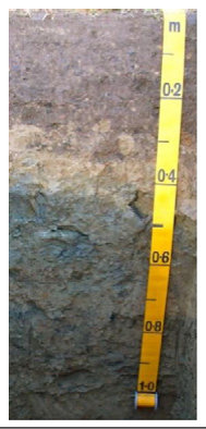
The second pit opened to expose a soil representative of the recontoured part of the vineyard was located under grass sward between vines (Fig. 5). This soil (HCR-LS, Mixed Anthropic) showed highly mixed soil horizons, which were designated mixed A and mixed B horizons (Table 1). Like the HCR-US soil these horizons showed the occlusions of allocthonous material that had been integrated in the recontouring process; for example subsoil and siltstone occlusions were found in the topsoil. The topsoil was a CL with moderate sub-angular blocky structure, whilst the subsoil was a massive very sticky and very plastic C horizon. Soil chemistry trends in the disturbed lower slope soil compared to its virgin counterpart showed increases in pH and EC over the profile, and higher TEB and exchangeable Na in the upper 50 cm of the profile (Table 3).
为揭示葡萄园重塑区代表性土壤而开挖的第二个样坑位于葡萄行间草带下(图5)。该土壤(HCR-LS,混合人为土)发生层高度混合,划分为混合A层和混合B层(表1)。与HCR-US土壤一样,这些发生层中夹杂有地形重塑过程中混入的外来物质,例如表土中可见心土和粉砂岩包裹体。表土为CL,具中等发育的次棱块状结构,而心土为块状、极黏着、极可塑的C层。与原生对照相比,扰动下坡土壤的化学性质表现为剖面pH和EC升高,且剖面上部50 cm的TEB和交换性Na较高(表3)。
Changes to soil morphology from recontouring on the Hardcase vineyard showed a shift towards a simple soil profile form that lacked horizon differentiation relative to the undisturbed soils. Virgin soils were classified under the New Zealand Soil Classification (Hewitt, 2010) as an Sodic Argillic Pallic soil on the basis of Sodic features (ESP N6%, Table 3), Argillic features (argillic horizons, continuous clay coatings), and Pallic soil features including moderate/high base status (Table 3), pale colour, and high subsoil bulk density (data not shown). The resultant recontoured soils were classified as Mixed Anthropic soils and had relatively simple profile forms; typically Ap/mixed-B/C. Recontouring has reduced contrasts within the soil, but potentially increased contrast between the solum (A and B horizons) and the R horizon. The greatest difference in soil morphology, aside from profile form, was a decrease in subsoil structure grade from moderate/ strong in the virgin soils to massive structureless in reconstructed soils.
Hardcase葡萄园地形重塑引起的土壤形态变化表现为:与未扰动土壤相比,土壤剖面趋于简单,缺乏发生层分异。根据新西兰土壤分类(Hewitt, 2010),原生土壤被划为钠质黏化淡色土,依据为钠质特征(ESP > 6%,表3)、黏化特征(黏化层、连续黏粒胶膜)以及淡色土特征,包括中等/较高盐基状况(表3)、浅淡颜色和较高的心土容重(数据未列出)。重塑后的土壤被划为混合人为土,剖面形态相对简单,通常为Ap/混合B/C。地形重塑降低了土壤内部的差异,但可能增大了土体(A层和B层)与R层之间的差异。除剖面形态外,土壤形态的最大差异在于心土结构等级由原生土壤的中等/强降为重构土壤的块状无结构。
Soil profile morphology data for upper slope soil pits on Hardcase property.
Hardcase地产上坡土壤样坑的剖面形态数据。
| Horizon发生层 | Colour颜色 | Mottles锈斑 | Texture质地 | Clasts碎屑 | Consistence结持性 | Structure结构 | Cutans胶膜 | Roots根系 |
|---|---|---|---|---|---|---|---|---|
| Upper virgin slope so NZSC: Sodic Argillic USDA soil tax.: typic | il pit (HCV-US) 41°42′ Pallic soil Haplustalf | 39.84″S 174° 6′49 | .86″E | |||||
| Ah 0–15 cm, cl, sm | 10 YR 4/2 | – | Silt loam | – | Friable, non sticky, plastic | Moderate,fine/ medium, blocky to moderate,fine, granular | – | Few, veryfine |
| Bw 15–25, gr sm | 10 YR 5/4 | – | Clay loam | – | Very friable, non sticky, plastic | Moderate, medium, blocky | – | Very few, very fine |
| Bt 25–90, gr sm | 10 YR 5/6 | Few,fine, faint, 7.5 YR 4/6 | Clay | – | Firm, sticky, plastic | Strong, medium/ coarse blocky | Few, faint, ped face 10 YR 5/3 | Few, veryfine |
| C 90–145+ | 2.5 YR 5/3, 5 YR 5/2 (siltstone) | – | Clay | – | Firm, very sticky, very plastic | Strong,fine/coarse, blocky | – | Very few, very fine |
| Upper recontour NZSC: mixed ant USDA soil tax.: ty上部重塑 NZSC:混合人 USDA土壤系统分类:典 | ed slope soil pit (HCR-US) 41°42′30.9 hropic pic Ustorthent坡面土壤样坑(HCR-US)41°42′30.9 为土 型干润正常新成土(Ustorthent) | 0″S 174° 7′5.34″E | |||||
|---|---|---|---|---|---|---|---|
| Ap mixed 0–40 c cl sm | m, 10 YR 4/2, 2.5 YR 5/4 (subsoil), 5 YR 5/3 (siltstone) – | Clay loam | – | Friable, sticky, plastic | Moderate, medium, blocky | – | Common, very fine/fine |
| B mixed 40–105+ | 2.5 YR 5/4, 10 YR 4/2 (topsoil), 5 YR 5/3 (siltstone) – | Clay | – | Friable, very sticky, very plastic | Massive | – | Few,fine |
Key for morphology: Horizon (distinctness/shape); Mottles (quantity/size/contrast); Texture; Consistency (dry or moist/stickiness/plasticity); Structure (grade/size/type); Cutans (amount/distinctness/location); Roots (abundance/size). Key for classification: NZSC — New Zealand Soil Classification (Hewitt, 2010), USDA Soil Tax. — United States Department of Agriculture Soil Taxonomy (Soil Survey Staff, 2010).
形态描述说明:发生层(明显度/形状);锈斑(数量/大小/对比度);质地;结持性(干或湿/黏着性/可塑性);结构(等级/大小/类型);胶膜(数量/明显度/位置);根系(丰度/大小)。分类说明:NZSC——新西兰土壤分类(Hewitt, 2010);USDA Soil Tax.——美国农业部土壤系统分类(Soil Survey Staff, 2010)。
3.2. Soil carbon and nitrogen3.2. 土壤碳和氮
Soil chemical properties.
土壤化学性质。
Within the virgin landscape, the analysis of variance showed significant differences (P b 0.05) in both C and N amongst the different slope units. Topsoil mass of both C and N was significantly (P b 0.05) higher in the footslope than in the midslope or summit. The latter two slope positions had non-significant differences.
在原生景观内,方差分析表明不同坡面单元之间碳和氮均存在显著差异(P < 0.05)。坡麓的表土碳和氮储量均显著(P < 0.05)高于坡腰或坡顶,而后两个坡位之间差异不显著。
| Horizon发生层 | pH (H2O) | EC (μS/cm) | ESP | Ca (meq | K /100 g | Mg soil)Mg soil) | Na | TEB | nificant diffe slope units. T nificant diffe slope units. T | rences (Pb 0. opsoil mass o rences (Pb 0. opsoil mass o | , 05) in both C f both C and N, 05) in both C f both C and N | and N amongst was significan and N amongst was significan | the differe tly (Pb 0.0 the differe tly (Pb 0.0 |
|---|---|---|---|---|---|---|---|---|---|---|---|---|---|
| HCV-US | higher in the | footslope than | in the midslo | pe or summit. T | he latter tw | ||||||||
| Ah | 5.4 | 75 | 2 | 6.2 | 1.7 | 1.7 | 0.2 | 9.8 | slope positio | ns had non-sig | nificant differe | nces. | |
| Bw | 5.9 | 51 | 2 | 5.9 | 0.2 | 2.1 | 0.2 | 8.3 | Sl | ii | i didf | hii | d |
| Bt (25–55 cm) | 6.8 | 83 | 7 | 11.5 | 0.1 | 5.3 | 1.2 | 18.1 | ampe s | emvarogram | s erve ro | m te vrgn | ransect a |
| Bt (55–85 cm) | 7.3 | 201 | 13 | 13.5 | 0.4 | 7 | 3.2 | 24 | showed spat | ial structure f | or both C and | N variability (F | ig. 6a and b |
| C | 7.2 | 467 | 18 | 11.4 | 0.6 | 7 | 4.2 | 23.1 | The range o | f both semiva | riograms and | hence the li | mit of spati |
| HCR-US | autocorrelati | on were abou | t 50 m, the li | mit of which co | rresponds | ||||||||
| Ap mixed | 6.2 | 64 | 2 | 9.4 | 0.8 | 3 | 0.4 | 13.6 | the characte | ristic dimensi | on of the slop | e elements. Th | e sills of th |
| B mixed (35–55 cm) | 7.8 | 110 | 3 | 16.9 | 0.6 | 4.4 | 0.4 | 22.3 | semivariogra | ms were 170, | 000 mg2 and 1 | 250 mg2 for C | and N, whic |
| B mixed (55–75 cm) | 7.2 | 57 | 4 | 11.8 | 0.6 | 5.2 | 0.7 | 18.3 | vary proport | ionately with | the respectiv | e sample vari | ances for th |
| B mixed (75–95 cm) | 8.2 | 184 | 6 | 12.9 | 1.5 | 4.5 | 1.2 | 20.2 | two soil prop | erties of 120, | 926 mg2 and 8 | 96 mg2. The nu | ll hypothes |
| HCV-LS | of data homo | scedasticity fo | r both C and N | could not be re | jected due | ||||||||
| Ah | 6.2 | 75 | 6 | 7.5 | 0.4 | 3.8 | 0.8 | 12.5 | Levene's test | values above P | b 0.05. | ||
| Bt1 | 6.4 | 83 | 8 | 7.4 | 0.1 | 4.5 | 1.1 | 13 | |||||
| Bt2 (35–55 cm) | 6.9 | 102 | 13 | 8.4 | 0.4 | 5 | 2 | 15.8 | |||||
| Bt2 (55–75 cm) | 6.9 | 779 | 23 | 11.4 | 0.3 | 7.5 | 6.2 | 27.3 | Table 4 | ||||
| Bt2 (75–95 cm) | 6.7 | 833 | 29 | 7.7 | 0.3 | 5.5 | 5.4 | 18.9 | Mean organic C | and N values on di | fferent virgin slop | e elements (n = 3 | 0). |
| HCR-LS | m C/soil | C std dev | mN/soil | N std dev | |||||||||
| Ap mixed | 7.0 | 222 | 8 | 10.4 | 0.6 | 3.1 | 1.2 | 15.2 | g fil | g fil | |||
| B mixed (30–50 cm) | 8.2 | 299 | 8 | 12.1 | 0.8 | 4.3 | 1.5 | 18.8 | proie | proie | |||
| B mixed (50–70 cm) | 8.6 | 347 | 13 | 16.9 | 0.7 | 6.1 | 3.7 | 27.4 | Footslope | 1116 | 382 | 100 | 33 |
| B mixed (70–90 cm) | 8.1 | 674 | 15 | 13.5 | 0.3 | 3.6 | 3.1 | 20.4 | Midslope | 732 | 358 | 66 | 33 |
| B mixed (90–110 cm) | 7.9 | 960 | 16 | 16.6 | 0.4 | 4.6 | 4.1 | 25.7 | Summit | 579 | 223 | 44.4 | 12 |
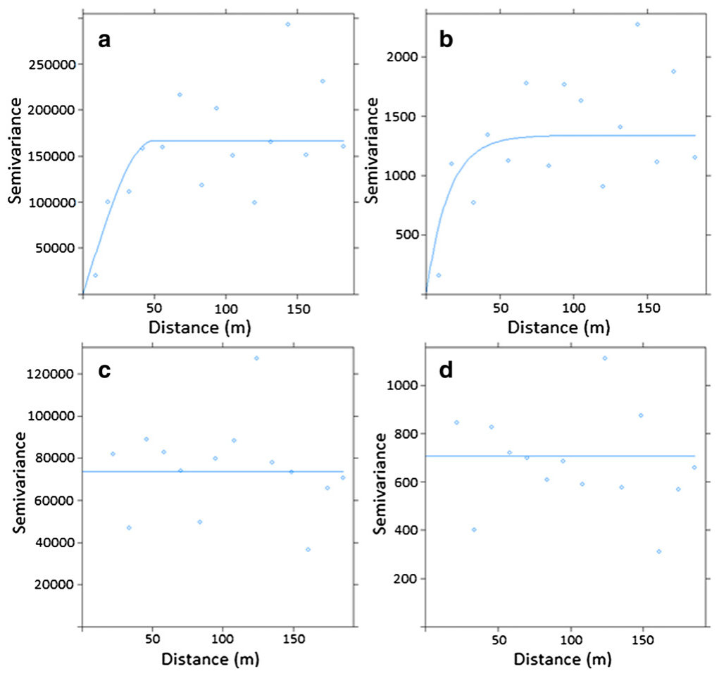
Sample semivariograms derived from the virgin transect data showed spatial structure for both C and N variability (Fig. 6a and b). The range of both semivariograms and hence the limit of spatial autocorrelation were about 50 m, the limit of which corresponds to the characteristic dimension of the slope elements. The sills of the semivariograms were 170,000 mg2 and 1250 mg2 for C and N, which vary proportionately with the respective sample variances for the two soil properties of 120,926 mg2 and 896 mg2. The null hypothesis of data homoscedasticity for both C and N could not be rejected due to Levene's test values above P b 0.05.
由原生样带数据得到的样本半变异函数显示碳和氮的变异均具有空间结构(图6a和b)。两个半变异函数的变程,即空间自相关的界限,约为50 m,与坡面单元的特征尺度相对应。碳和氮半变异函数的基台值分别为170,000 mg2和1250 mg2,与两种土壤性质各自的样本方差(120,926 mg2和896 mg2)成比例。由于Levene检验值高于P = 0.05,无法拒绝碳和氮数据方差齐性的原假设。
Mean organic C and N values on Recontoured/Virgin sites (n = 60).
重塑/原生场地有机碳和氮平均值(n = 60)。
| mg C/soil profilemg C/土壤 剖面 | C std dev | mg N/soil profilemg N/土壤 剖面 | N Std dev | |
|---|---|---|---|---|
| Recontoured | 683 | 270 | 75 | 25 |
| Virgin | 855 | 403 | 59 | 36 |
Table 6表6
Average EC and pH for the three drainage transects (n = 44).
三条排水样带的EC和pH平均值(n = 44)。
| EC (μS/cm) | EC Std dev | pH (H2O) | pH Std dev | |
|---|---|---|---|---|
| Gully | 719 | 565 | 6.7 | 0.6 |
| Non-gully | 228 | 160 | 6.2 | 0.9 |
The transects on the recontoured land were not stratified in any way owing to the homogeneity of the topography. The analysis of variance between the recontoured and virgin parts areas showed no significant difference between soil profile masses of C, but a significant difference (P b 0.05) for N. The r-square value for the ANOVA for N showed, however, that the treatment effect (recontoured vs virgin) accounted for less that 5% of the variance, leaving the remaining 95% accounted for by other effects such as topographic effects on soil N profile mass. Sample semivariograms from the transects showed pure nugget effect for both C and N, implying that any structure to the spatial variation in N and C on recontoured land occurs over distances less than the minimum sample separation (20 m). The sills for the semivariograms, which are equivalent to the nugget variances, were 76,000 mg2 and 720 mg2 for C and N, respectively. These compare to the variance that they approximate of 73,041 mg2 and 648 mg2, respectively. The overall effect of recontouring on profile C and N contents is one of the homogenisations without significant loss of either soil component.
由于地形均一,重塑土地上的样带未作任何分层。重塑区与原生区之间的方差分析表明,碳的土壤剖面储量无显著差异,但氮存在显著差异(P < 0.05)。然而,氮ANOVA的R²值表明,处理效应(重塑与原生)仅解释了不到5%的方差,其余95%由其他效应(如地形对土壤氮剖面储量的影响)解释。样带的样本半变异函数显示碳和氮均为纯块金效应,表明重塑土地上碳和氮空间变异的任何结构均发生在小于最小采样间距(20 m)的尺度上。碳和氮半变异函数的基台值(等同于块金方差)分别为76,000 mg2和720 mg2,而其所近似的方差分别为73,041 mg2和648 mg2。总体而言,地形重塑对剖面碳和氮含量的影响表现为均一化,而两种土壤组分均无显著损失。
The hypothesis that recontouring would reduce topsoil organic C and N was rejected on the strength of a lack of significant difference between virgin and recontoured soil organic C, and a low R-squared value (0.04) for the P b 0.05 significant difference for organic N. This result confirms that it is possible, with appropriate recontouring practices, to carry out recontouring and not cause a decrease in topsoil organic matter. Contributing factors for this result may include the care taken by site owners to keep topsoil in piles for the minimum amount of time possible and to re-spread it to generally even thicknesses. In contrast, recontouring had a significant effect on the spatial variability of C and N. Virgin soils showed significant differences (at 95% confidence) in organic C and N between slope positions (summit-footslope, midslope-footslope), with the highest to lowest values in the order footslope to midslope to summit. Robertson et al. (1993) also found an altered variability structure in soil properties (gravimetric water, inorganic P, total C) of disturbed land as compared to virgin land, although the cited study disturbance was due to cultivation (Robertson et al., 1993). The range over which spatial dependence of soil properties was expressed in the study by Robertson et al. (1993) was greater in the cultivated soil (48–108 m) than in the undisturbed soil (7–26 m). This pattern is the opposite to what was observed in Hardcase vineyard topsoil organic C and N data, and may reflect the large weighting of disturbance type on its resulting effect on spatial dependence. The combination of topsoil homogenisation and no significant loss in topsoil organic C and
由于原生与重塑土壤有机碳之间无显著差异,且有机氮在P < 0.05水平上的显著差异对应的R²值较低(0.04),故拒绝“地形重塑会降低表土有机碳和氮”的假设。这一结果证实,采用适当的重塑措施,可以在进行地形重塑的同时不导致表土有机质减少。促成这一结果的因素可能包括场地所有者注意尽量缩短表土堆存时间,并将其以大致均匀的厚度重新摊铺。相比之下,地形重塑对碳和氮的空间变异具有显著影响。原生土壤中有机碳和氮在不同坡位之间(坡顶—坡麓、坡腰—坡麓)存在显著差异(95%置信水平),由高到低依次为坡麓、坡腰、坡顶。Robertson et al.(1993)同样发现,与原生土地相比,扰动土地土壤性质(重量含水量、无机磷、全碳)的变异结构发生了改变,但该研究中的扰动源于耕作(Robertson et al., 1993)。在Robertson et al.(1993)的研究中,土壤性质空间依赖性的变程在耕作土壤中(48–108 m)大于未扰动土壤(7–26 m)。这一规律与Hardcase葡萄园表土有机碳和氮数据的观测结果相反,这可能反映了扰动类型对其空间依赖性影响的重要作用。表土均一化与表土有机碳和
N resulting from recontouring may be a desirable effect for the vineyard. Soil variability in Marlborough has been shown to be a driver of intravineyard crop variability, and hence resultant juice quality (Bramley et al., 2011; Trought and Bramley, 2011). With soil variability on Hardcase having been reduced by topsoil homogenisation, it could be expected that blocks of vines will ripen more uniformly than if vines had been planted in the more variable virgin soil.
氮无显著损失二者结合,可能是地形重塑对葡萄园产生的有利效应。研究表明,马尔堡的土壤变异是葡萄园内作物变异进而影响果汁品质的驱动因素(Bramley et al., 2011; Trought and Bramley, 2011)。由于表土均一化降低了Hardcase的土壤变异,可以预期,与种植于变异较大的原生土壤相比,葡萄地块的成熟将更为一致。
3.3. Soil salinity3.3. 土壤盐渍化
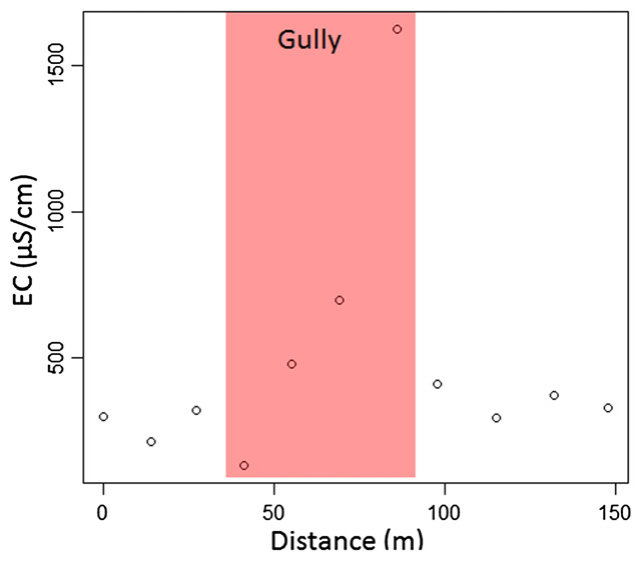
Statistical analysis of EC and pH data of ‘Gully’ versus ‘Non-gully’ soil auger samples showed a significant difference in EC (P b 0.001), and no difference in pH. Depth trends of EC at different soil auger depths (20–30 cm, 40–50 cm, and 70–80 cm) showed the highest EC at 20 cm in the main gully fill (Transect 2, Fig. 4), whereas across the infilled tributary gully (Transect 1) EC reached its highest value at 70 cm depth (depth data not shown). The high EC values were not accompanied by an increase in pH as would have occurred if the increase in salinity was due to an abundance of siltstone clasts in the fill material. Instead it appears that the increase in EC is due to the concentration of salts in the gully fill by leaching and throughflow. The higher concentration of salts towards the surface of the large gully relative to the smaller gully reflects differences in their contributing areas, and the frequency and magnitude of saturation events. In winter 2010 a seep formed along the length of the large gully, which brought salts that formed a surface efflorescence and killed grapevines (Pers. Comm. P. Clark, 2013). Fig. 7 shows the EC profile of the auger transect that traverses the main infilled gully (Transect 2 in Fig. 4). There is an abrupt increase in EC in the ‘Gully’ area, dominantly in the final auger hole of the ‘Gully’ zone.
对“冲沟”与“非冲沟”土钻样品EC和pH数据的统计分析表明,EC存在显著差异(P < 0.001),而pH无差异。不同钻孔深度(20–30 cm、40–50 cm和70–80 cm)EC的深度变化趋势显示,主冲沟填土(样带2,图4)中EC在20 cm处最高,而在横穿已填平支沟的样带1中,EC在70 cm深度达到最高值(深度数据未列出)。高EC值并未伴随pH升高,而若盐分增加源于填土中大量粉砂岩碎屑,则pH应会升高。因此,EC的升高似乎是由于淋溶和壤中流作用使盐分在冲沟填土中富集。大冲沟相对于小冲沟在近地表处盐分浓度较高,反映了二者汇水面积以及饱和事件频率和强度的差异。2010年冬季,沿大冲沟全长形成了渗流带,带来的盐分形成地表盐霜并导致葡萄藤死亡(Pers. Comm. P. Clark, 2013)。图7显示了横穿主填平冲沟的钻孔样带(图4中样带2)的EC剖面。在“冲沟”区域EC急剧升高,主要出现在“冲沟”区的最后一个钻孔。
Recontouring effects on site hydrology are also interesting as the relief in the underlying bedrock on Hardcase has been reduced in the process; a review of a group of studies in New Zealand on hillslope hydrology noted that bedrock topography appeared to determine spatially the pathway of rapid saturated subsurface water flow and tracer breakthrough at a hillslope scale (McGlynn et al., 2002). This suggests that former gullies (now infilled) will still receive subsurface water flows as directed by upstream surface and bedrock topography in unmodified areas, but that lateral throughflow may be diffuse. Vine growth and viticultural production are likely to be adversely affected at the high end of these EC values (Paranychianakis and Chartzoulakis, 2005). Alterations to finished wine pH and colour in wine made from grapes grown in high salinity soil may be seen as a potential positive outcome (Walker et al., 2000).
地形重塑对场地水文的影响同样值得关注,因为Hardcase下伏基岩的起伏在此过程中被削减。一篇针对新西兰坡面水文系列研究的综述指出,在坡面尺度上,基岩地形似乎在空间上决定了快速饱和地下水流及示踪剂穿透的路径(McGlynn et al., 2002)。这表明,原有冲沟(现已填平)仍将接收由未改造区域上游地表和基岩地形所导引的地下水流,但侧向壤中流可能较为弥散。在这些EC值的高值端,葡萄生长和葡萄生产可能受到不利影响(Paranychianakis and Chartzoulakis, 2005)。以高盐分土壤中种植的葡萄酿造的葡萄酒,其成品pH和颜色的改变可能被视为潜在的积极结果(Walker et al., 2000)。
3.4. Pond water3.4. 池塘水
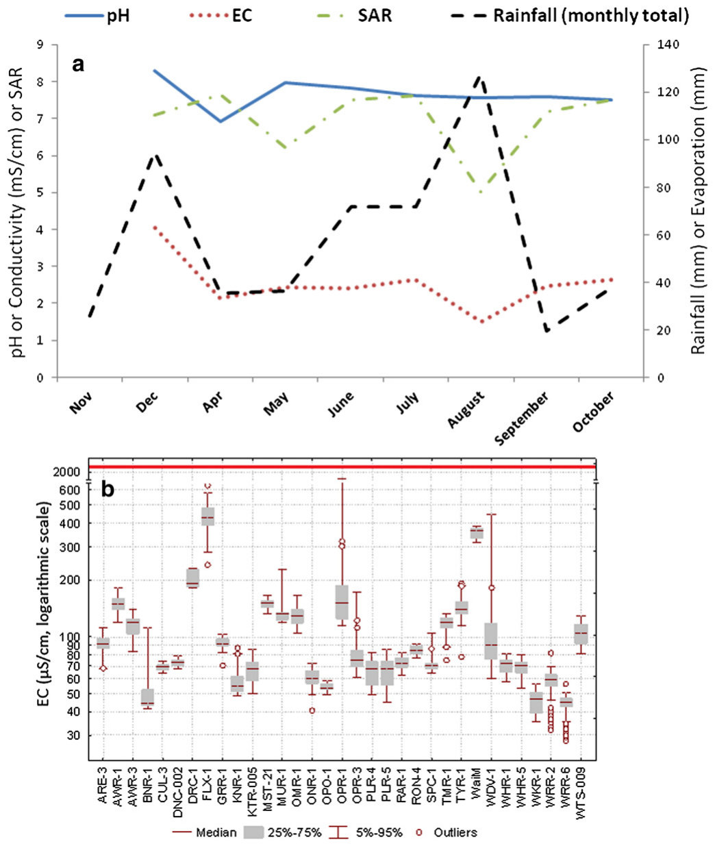
The pond collecting the drainage from the vineyard had a year-round moderate-high pH (average 7.7) and high EC (average 2.5 mS/cm, Fig. 8a). Water EC appeared to respond to rainfall; after high rainfall months the salt content was diluted (e.g. August). The pH fluctuated less with changing rainfall and evaporation values. The Sodium Adsorption Ratio (SAR) is an indicator of the amount of sodium relative to calcium and magnesium; higher values indicate higher amounts of sodium and increased risk of reduced infiltration due to clay dispersion (Grattan, 1999). The SAR responded similarly to EC, decreasing when rainfall increased.
汇集葡萄园排水的池塘全年pH中等偏高(平均7.7),EC较高(平均2.5 mS/cm,图8a)。水体EC似乎对降雨有响应,高降雨月份后盐分含量被稀释(如8月)。pH随降雨和蒸发的变化波动较小。钠吸附比(SAR)是表征钠相对于钙和镁含量的指标,数值越高表明钠含量越高,黏粒分散导致入渗降低的风险越大(Grattan, 1999)。SAR的响应与EC相似,随降雨增加而降低。
Comparison of the EC values from this pond with those of 34 reference waterways, including areas of similar geology, around the Marlborough region (Fig. 8b) shows recontouring not only is resulting in remobilisation of salts into gully fills, but also salts are accumulating in the irrigation pond to levels much greater than those present in natural waterways in the region.
将该池塘EC值与马尔堡地区34条参照水道(包括地质条件相似的区域)的EC值比较(图8b)表明,地形重塑不仅导致盐分再迁移至冲沟填土中,而且盐分在灌溉池塘中积累,其水平远高于该地区天然水道。
4Conclusion结论
Landscape recontouring has had a variety of effects on soils and near-surface hydrology on a hilly vineyard site in the Awatere Valley. Recontoured soils have shown a shift towards more simple profile forms. The morphological differences have led to the recontoured soils being classified as Mixed Anthropic Soils comprising a sequence of restored A horizon material over mixed, reconstituted B + C horizon material, in place of the A/Bt/B(x) horizon sequence characteristic of the Sodic Argillic Pallic soils found in the undisturbed landscape. Reconstructed soils lacked the strong structure of the virgin soils, which together with high exchangeable Na may predispose them to dispersion, compaction, and possibly enhanced erosion. Potential methods of enhancing soil structure restoration and alleviating high exchangeable Na include the application of gypsum and encouraging plant growth. Recontouring resulted in no significant difference in profile mass of organic C when compared to virgin soils, but spatial variability was reduced in magnitude. These results suggest recontoured land may produce grapes of more uniform characteristics and hence quality.
景观地形重塑对Awatere Valley一处丘陵葡萄园场地的土壤及近地表水文产生了多方面影响。重塑土壤的剖面形态趋于简单。形态差异使重塑土壤被划为混合人为土,其由恢复的A层物质覆盖于混合重构的B + C层物质之上,取代了未扰动景观中钠质黏化淡色土特有的A/Bt/B(x)发生层序列。重构土壤缺乏原生土壤的强结构,加之交换性Na较高,可能使其易发生分散、压实,并可能加剧侵蚀。促进土壤结构恢复和缓解高交换性Na的潜在方法包括施用石膏和促进植物生长。与原生土壤相比,地形重塑未导致有机碳剖面储量出现显著差异,但空间变异幅度降低。这些结果表明,重塑土地可能产出特性更为一致、因而品质更为一致的葡萄。
Infilled gullies remain the zones of water transport although as throughflow rather than channelised flow. Solutes, and in particular salts, have been mobilised in diffuse throughflow and concentrated in the centre of infilled gullies, creating zones of high EC, and in some areas, zones of seeps of saline water. The source of the salts is siltstone bedrock incorporated into gully fills and surrounding reconstructed soils. An irrigation pond designed to collect drainage from the landscape now has salinity levels above that recommended for irrigation. This issue may potentially be alleviated by draining the irrigation pond and letting it refill with fresh rainwater, but it is likely that more salts will accumulate as a result of rainwater throughflow in the surrounding landscape.
填平的冲沟仍是水分输送带,但以壤中流而非渠道流的形式输送。溶质,尤其是盐分,在弥散的壤中流中被迁移并富集于填平冲沟的中心,形成高EC区,部分区域还形成咸水渗流带。盐分来源于混入冲沟填土及周边重构土壤中的粉砂岩基岩。原设计用于汇集景观排水的灌溉池塘,其盐分水平目前已超过灌溉推荐值。排空灌溉池塘并使其重新蓄积新鲜雨水可能缓解这一问题,但周边景观中雨水壤中流很可能导致更多盐分积累。
A follow up study in 5–10 years time could prove useful in understanding the long term effects of recontouring on the soil resource in the Awatere Valley sub region in Marlborough, New Zealand.
在5–10年后开展后续研究,将有助于了解地形重塑对新西兰马尔堡Awatere Valley子区域土壤资源的长期影响。
Acknowledgments致谢
I would like to acknowledge the Marlborough District Council for funding this study and also for providing the water conductivity data for 34 waterways in Marlborough (Fig. 8b).
感谢马尔堡区议会(Marlborough District Council)资助本研究,并提供马尔堡34条水道的水体电导率数据(图8b)。
References参考文献
Banning, N.C., Grant, C.D., Jones, D.L., Murphy, D.V., 2008. Recovery of soil organic matter, organic matter turnover and nitrogen cycling in a post-mining forest rehabilitation chronosequence. Soil Biol. Biochem. 40 (8), 2021–2031.
Blakemore, L.C., Searle, P.L., Daly, B.K., 1987. Methods for chemical analysis of soils. N.Z. Soil Bur. Sci. Rep. 80. Bramley, R.G.V., Trought, M.C.T., Praat, J.P., 2011. Vineyard variability in Marlborough, New Zealand: characterising variation in vineyard performance and options for the implementation of Precision Viticulture. Aust. J. Grape Wine Res. 17 (1), 72–78.
Certini, G., Scalenghe, R., 2011. Anthropogenic soils are the golden spikes for the Anthropocene. The Holocene 21 (8), 1269–1274. Daniel, T.C., 2001. Whither scenic beauty? Visual landscape quality assessment in the 21st century. Landsc. Urban Plan. 54 (1–4), 267–281.
Elementar, 2013. Elementar website. (Accessed 25/10/2013 from www.elementar.de). ESRI, 2012. ArcGIS Desktop: Release 10. Environmental Systems Research Institute, Redlands, CA. Farifteh, J., Farshad, A., George, R.J., 2006. Assessing salt-affected soils using remote sensing, solute modelling, and geophysics. Geoderma 130 (3–4), 191–206. Grattan, R.S., 1999. Irrigation Water Salinity and Crop Production, Farm Water Quality Planning Reference Sheet 9.10. University of California. Harris, J.A., Birch, P., 1989. Soil microbial activity in opencast coal mine restorations. Soil Use Manag. 5 (4), 155–160. Hewitt, A.E., 2010. New Zealand Soil Classification, Third ed. Manaaki Whenua Press, Lincoln, Canterbury, New Zealand. Hunziker, M., Kienast, F., 1999. Potential impacts of changing agricultural activities on scenic beauty — a prototypical technique for automated rapid assessment. Landsc. Ecol. 14 (2), 161–176. Koch, J.M., 2007. Alcoa's mining and restoration process in South Western Australia. Restor. Ecol. 15, 11–S16. Kosmas, C., Danalatos, N., Cammeraat, L.H., Chabart, M., Diamantopoulos, J., Farand, R., Gutierrez, L., Jacob, A., Marques, H., Martinez-Fernandez, J., Mizara, A., Moustakas, N., Nicolau, J.M., Oliveros, C., Pinna, G., Puddu, R., Puigdefabregas, J., Roxo, M., Simao, A., Stamou, G., Tomasi, N., Usai, D., Vacca, A., 1997. The effect of land use on runoff and soil erosion rates under Mediterranean conditions. Catena 29 (1), 45–59.
Landcare Research, 2013. New Zealand Land Resource Inventory (NZLRI) database. (Accessed 18/10/2013 from http://lris.scinfo.org.nz/). Lynn, I.H., 2009. A Brief Scoping Study of Landscape Recontouring for Viticulture in Eastern Marlborough. Landcare Research Contract Report LC0809/074, prepared for Marlborough District Council. McGlynn, B.L., McDonnel, J.J., Brammer, D.D., 2002. A review of the evolving perceptual model of hillslope flowpaths at the Maimai catchments, New Zealand. J. Hydrol. 257 (1–4), 1–26. Meyer, A., Martınez-Casasnovas, J.A., 1999.́ Prediction of existing gully erosion in vineyard parcels of the NE Spain: a logistic modelling approach. Soil Tillage Res. 50 (3–4), 319–331.
NIWA CliFlo, 2013. NZ National Climate Database. National Institute of Water and Air, Wellington, NZ (Accessed 2/6/2013 from http://cliflo.niwa.co.nz/). Paranychianakis, N.V., Chartzoulakis, K.S., 2005. Irrigation of Mediterranean crops with saline water: from physiology to management practices. Agric. Ecosyst. Environ. 106 (2–3), 171–187. Pebesma, E.J., 2004. Multivariable geostatistics in S: the gstat package. Comput. Geosci. 30, 683–691. Ramos, M.C., Martínez-Casasnovas, J.A., 2007. Soil loss and soil water content affected by land levelling in Penedès vineyards, NE Spain. Catena 71 (2), 210–217. Ramos, M.C., Nacci, S., Pla, I., 2000. Soil sealing and its influence on erosion rates for some soils in the Mediterranean area. Soil Sci. 165 (5), 398–403.
Ramos, M.C., Cots-Folch, R., Martínez-Casasnovas, J.A., 2007. Effects of land terracing on soil properties in the Priorat region in Northeastern Spain: a multivariate analysis. Geoderma 142 (3–4), 251–261.
Rattenbury, M.S., Townsend, D.B. and Johnston, M.R., 2006. Geology of the Kaikoura Area, 1:250 000 Geological Map 13. GNS Science, Lower Hutt, New Zealand. Richter, D.D., 2007. Humanity's transformation of Earth's soil: Pedology's new frontier. Soil Sci. 172 (12), 957–967.
Robertson, G.P., Crum, J.R., Ellis, B.G., 1993. The spatial variability of soil resources following long-term disturbance. Oecologia 96 (4), 451–456.
Ruddiman, W.F., Ellis, E.C., 2009. Effect of per-capita land use changes on Holocene forest clearance and CO2 emissions. Quat. Sci. Rev. 28 (27–28), 3011–3015.
Schäffer, B., Eggenschwiler, L., Suter, B., Vogt, L., Buchter, B., Pfister, H., Schulin, R., 2007. Influence of temporary stockpiling on the initial development of restored topsoils. J. Plant Nutr. Soil Sci. 170 (5), 669–681.
Schmugge, T.J., Kustas, W.P., Ritchie, J.C., Jackson, T.J., Rango, A., 2002. Remote sensing in hydrology. Adv. Water Resour. 25 (8–12), 1367–1385.
Soil Survey Staff, 2010. Keys to Soil Taxonomy, In: Soil Survey Staff (Ed.), 11th ed. USDA- Natural Resources Conservation Service, Washington, DC. Taylor, N.H., Pohlen, I.J., 1962. Soil Survey Method: A New Zealand Handbook for the Field Study of Soils. Soil Bureau bulletin no. 25New Zealand Department of Scientific and Industrial Research.
Theng, B.K.G., 1980. Soils With Variable Charge. N.Z. Society of Soil Science, Lower Hutt, N.Z. Trought, M.C.T., Bramley, R.G.V., 2011. Vineyard variability in Marlborough, New Zealand: characterising spatial and temporal changes in fruit composition and juice quality in the vineyard. Aust. J. Grape Wine Res. 17 (1), 79–89.
Walker, R.R., Read, P.E., Blackmore, D.H., 2000. Rootstock and salinity effects on rates of berry maturation, ion accumulation and colour development in Shiraz grapes. Aust. J. Grape Wine Res. 6 (3), 227–239.
Singer, M.J., Le Bissonnais, Y., 1998. Importance of surface sealing in the erosion of some soils from a Mediterranean climate. Geomorphology 24 (1), 79–85.