Available online at www.sciencedirect.com
Agricultural Systems 96 (2008) 124–138
www.elsevier.com/locate/agsy
Mario Gellrich a,b,*, Priska Baur b, Brett Harvey Robinson a, Peter Bebi b
a Institute of Terrestrial Ecosystems, Swiss Federal Institute of Technology (ETH), Universitaetstrasse 16, CH-8092 Zurich, Switzerland b Swiss Federal Institute for Forest, Snow and Landscape Research WSL, Zuercherstrasse 111, CH-8903 Birmensdorf, Switzerland
a 瑞士联邦理工学院(ETH)陆地生态系统研究所,Universitaetstrasse 16, CH-8092 Zurich, Switzerland b 瑞士联邦森林、雪与景观研究所(WSL),Zuercherstrasse 111, CH-8903 Birmensdorf, Switzerland
Received 26 September 2006; received in revised form 29 June 2007; accepted 11 July 2007
Available online 24 August 2007
Abstract摘要
Natural reforestation reflects a decline in traditional agricultural practices. In the last decades, natural forest re-growth has replaced much of the grasslands in the Swiss mountains. This is an area where traditional cultivation has preserved unique landscapes and habitats of high ecological value. We investigated the patterns and determinants of natural reforestation of sub-alpine grasslands at the sub-parcel level using raster cells as the units of the analysis, and at the municipality-level. The study encompassed four municipalities in the Swiss Alps. Land-use data were derived from aerial photographs taken between the 1950s and 2000. We derived the research design for fieldwork (interviews in this study) from spatial statistical models (classification trees in this study). This method is known as the ‘‘finding answers in the errors’’ approach. This allowed us to relate the behaviour of landowners and operators to changes in land-use/land-cover types, which is one of the main challenges in land-use/land-cover change research.
自然再造林反映了传统农业生产方式的衰退。近几十年来,瑞士山区的大部分草地已被自然恢复的森林所取代。在这一地区,传统耕作保存了独特的景观以及具有较高生态价值的生境。本研究以栅格单元为分析单位,在亚地块尺度和市镇尺度上研究了亚高山草地自然再造林的格局及其驱动因素。研究区包括瑞士阿尔卑斯山区的4个市镇。土地利用数据来源于1950年代至2000年间拍摄的航空像片。我们依据空间统计模型(本研究中为分类树)确定野外调查(本研究中为访谈)的研究设计,该方法被称为“在误差中寻找答案”法。借此,我们能够将土地所有者和经营者的行为与土地利用/土地覆被类型的变化联系起来,而这正是土地利用/土地覆被变化研究面临的主要挑战之一。
Three of four classification trees accurately described the locations where natural reforestation occurred, which was mostly on steep and north-facing slopes. However, additional information from interviews was necessary to understand the patterns and determinants of reforestation. Interviews revealed that policy factors (e.g. delayed land consolidations) enhanced forest re-growth. Some sites remained under cultivation despite model predictions of reforestation. Socio-economic factors, not incorporated into the models, explained these discrepancies. These factors included the opportunity costs of farm labour (e.g. aged farmers retaining traditional practices), a conversion to low-cost cultivation practices (e.g. deer and horse pasturing), agri-environmental requirements (e.g. land required to avoid exceeding the prescribed number of livestock per hectare) or other benefits (e.g. hobby farming). Many farms were abandoned during the 50-year study period. The remaining farms often increased in size, whereas farm labour remained stable or decreased. Farm labour costs increased faster than incomes, leading to undergrazing and the cessation of tree and shrub clearance. Although our discussion references specific case study areas, our methods are applicable to the study of other areas undergoing land-use change. � 2007 Elsevier Ltd. All rights reserved.
4棵分类树中有3棵准确描述了自然再造林发生的位置,这些位置主要位于陡坡和北坡。然而,要理解再造林的格局及其驱动因素,还需借助访谈获得的补充信息。访谈表明,政策因素(如土地整理的延迟)促进了森林的恢复。部分地块尽管模型预测会发生再造林,但仍保持耕作。模型中未纳入的社会经济因素解释了这些偏差,这些因素包括农业劳动力的机会成本(如年长农民保留传统耕作方式)、向低成本耕作方式的转变(如放牧鹿和马)、农业环境要求(如为避免超过规定的每公顷牲畜数量而需要的土地)或其他收益(如业余农耕)。在50年的研究期内,许多农场被弃耕。留存农场的规模往往扩大,而农业劳动力则保持稳定或减少。农业劳动力成本的增长快于收入增长,导致放牧不足以及树木和灌木清理的停止。尽管本文的讨论针对特定的案例研究区,但所用方法同样适用于其他正在经历土地利用变化的地区。© 2007 Elsevier Ltd. 版权所有。
Keywords: Agriculture; Alpine pastures; Land abandonment; Finding answers in the errors; LULCC; Reforestation; Switzerland
关键词:农业;高山牧场;土地弃耕;在误差中寻找答案;土地利用/土地覆被变化(LULCC);再造林;瑞士
1Introduction引言
Increasingly, policymakers and researchers confront problems resulting from land-use/land-cover changes (LULCC) from local to regional scales. Soil degradation, environmental pollution and decreasing biodiversity are worldwide problems resulting from LULCC (Meyer and Turner, 1994; DLG, 2005). LULCC can also be beneficial. For example, natural reforestation of agricultural land, as investigated in this study, can contribute to the stabilisation of soils (Tasser et al., 2003), carbon sequestration (Houghton et al., 1999) and a temporary increase of biodiversity (Laiolo et al., 2004).
从局地到区域尺度,政策制定者和研究人员日益面临由土地利用/土地覆被变化(LULCC)所引发的问题。土壤退化、环境污染和生物多样性下降是由LULCC导致的全球性问题(Meyer and Turner, 1994; DLG, 2005)。LULCC也可能带来益处。例如,本研究所探讨的农业用地自然再造林有助于土壤稳定(Tasser et al., 2003)、碳固存(Houghton et al., 1999)以及生物多样性的暂时增加(Laiolo et al., 2004)。
* Corresponding author. Present address: Institute of Terrestrial Ecosystems, Swiss Federal Institute of Technology (ETH), Universitaetstrasse 16, CH-8092 Zurich, Switzerland. Tel.: +41 44 632 45 90.
* 通讯作者。现地址:瑞士联邦理工学院(ETH)陆地生态系统研究所,Universitaetstrasse 16, CH-8092 Zurich, Switzerland。电话:+41 44 632 45 90。
E-mail address: mario.gellrich@env.ethz.ch (M. Gellrich).
0308-521X/$ - see front matter � 2007 Elsevier Ltd. All rights reserved. doi:10.1016/j.agsy.2007.07.002
0308-521X/$ - see front matter © 2007 Elsevier Ltd. 版权所有。doi:10.1016/j.agsy.2007.07.002
Scholars have used various approaches to reveal the determinants of LULCC. One of the most common is spatial statistical modelling (Lesschen et al., 2005), which can reveal the factors determining LULCC and/or characterise the locations where changes have occurred. A common problem for LULCC modellers is that adequate socio-economic data are not available for use in spatial statistical models. Socio-economic data should be collected at the plot or parcel level, i.e. the level at which landowners make their land-use decisions (Irwin and Geoghegan, 2001). However, socio-economic data are often only available for administrative units such as municipalities or settlements.
学者们采用多种方法揭示LULCC的驱动因素,其中最常用的方法之一是空间统计建模(Lesschen et al., 2005),它可以揭示决定LULCC的因素和/或刻画发生变化的位置特征。LULCC建模者面临的一个普遍问题是,缺乏可用于空间统计模型的充足社会经济数据。社会经济数据应在地块或宗地尺度上收集,即土地所有者做出土地利用决策的尺度(Irwin and Geoghegan, 2001)。然而,社会经济数据往往只能按市镇或居民点等行政单元获得。
This lack of socio-economic data has led LULCC modellers to focus on large administrative units. Allen and Barnes (1985) investigated the causes of deforestation using a sample of 39 developing countries. Wood and Skole (1998) merged satellite images with census data for municipios, an administrative unit in the Brazilian Amazon, to examine determinants of deforestation. Other approaches use aggregate socio-economic variables to model LULCC at disaggregated levels. Mu¨ller and Zeller (2002) linked village-level information to the pixels from satellite images within municipalities. This revealed the influence of village-level factors on the land-use dynamics in the central highlands of Vietnam. Rudel et al. (2000) linked census data at the municipality-level to inventory plots within municipalities to examine the causes of reforestation of agricultural land in Puerto Rico. Models that use aggregate socio-economic data may provide useful information about the determinants of land-use/land-cover changes. However, they are inadequate for the examination of processes at decision relevant levels, i.e. at the plot, parcel or sub-parcel level, and are thus ineffective for the study of LULCC processes.
由于缺乏社会经济数据,LULCC建模者往往着眼于较大的行政单元。Allen and Barnes(1985)以39个发展中国家为样本研究了毁林的成因。Wood and Skole(1998)将卫星影像与巴西亚马孙地区行政单元municipios的普查数据相结合,考察了毁林的驱动因素。其他方法则利用汇总的社会经济变量在分解尺度上模拟LULCC。Müller and Zeller(2002)将村级信息与市镇内卫星影像的像元相关联,揭示了村级因素对越南中部高原土地利用动态的影响。Rudel et al.(2000)将市镇尺度的普查数据与市镇内的清查样地相关联,考察了波多黎各农业用地再造林的成因。利用汇总社会经济数据的模型可以为土地利用/土地覆被变化的驱动因素提供有用信息,但不足以考察决策相关尺度(即地块、宗地或亚宗地尺度)上的过程,因而难以有效研究LULCC过程。
Unravelling the detailed-scale mechanisms of LULCC requires a link between the land and information from land operators and households. However, this approach is challenging. Farmhouses are often distant from their fields, making it difficult to link farm-level data to the land-use changes observed from aerial photographs or satellite images (e.g. Entwisle et al., 1998). Few studies integrate spatial statistical modelling and interviews. McCracken et al. (1999) successfully predicted land-cover changes at the property level in the Brazilian Amazon. Here, the households lived on well-defined plots and had little impact on adjacent land. Thompson et al. (2002) interviewed pastoralists in Kenya to classify land-use strategies, and then developed statistical models to explain these strategies. A shortcoming of approaches that integrate data from interviews into statistical models is that the collection and georeferencing of interview data is expensive.
要揭示LULCC的精细尺度机制,需要将土地与来自土地经营者和农户的信息联系起来,但这一方法颇具挑战性。农舍往往远离其田块,因而难以将农场尺度的数据与航空像片或卫星影像所观测到的土地利用变化联系起来(如Entwisle et al., 1998)。将空间统计建模与访谈相结合的研究为数不多。McCracken et al.(1999)成功预测了巴西亚马孙地区产权地块尺度上的土地覆被变化,在该研究中,农户居住在边界清晰的地块上,对相邻土地影响甚微。Thompson et al.(2002)通过访谈肯尼亚牧民对土地利用策略进行分类,随后建立统计模型来解释这些策略。将访谈数据整合进统计模型的方法存在一个不足,即访谈数据的收集和地理配准成本高昂。
Here, we investigate the natural reforestation of sub-alpine grasslands caused by agricultural land abandonment. Land abandonment and reforestation is a worldwide phenomenon (Rudel et al., 2000; DLG, 2005). In western European countries, it often occurs in areas with unfavourable production conditions (Baldock et al., 1996; MacDonald et al., 2000). For example, in the Baltic countries, Estonia, Latvia and Lithuania, between 10% and 21% of the agricultural land was categorised as abandoned in 1999 and 2002, respectively (DLG, 2005). Valuable seminatural grassland may also become reforested. Swiss forestlands increased by 17,000 ha (1.4%) between the 1980s and 1990s. Natural reforestation was responsible for 87% of the newly wooded land (SFSO, 2001).
本文研究由农业土地弃耕引起的亚高山草地自然再造林。土地弃耕与再造林是一种全球性现象(Rudel et al., 2000; DLG, 2005)。在西欧国家,这一现象多发生于生产条件不利的地区(Baldock et al., 1996; MacDonald et al., 2000)。例如,在波罗的海国家爱沙尼亚、拉脱维亚和立陶宛,1999年和2002年分别有10%至21%的农业用地被归为弃耕地(DLG, 2005)。有价值的半自然草地也可能发生再造林。1980年代至1990年代间,瑞士林地面积增加了17,000 ha(1.4%),其中87%的新增林地源于自然再造林(SFSO, 2001)。
Usually, patterns and causes of land abandonment and reforestation are investigated using census and other aggregated data (e.g. Baldock et al., 1996; Rudel et al., 2000; Gellrich and Zimmermann, 2007). Although individuals make land-use decisions, there is a lacuna of knowledge about the individual motivation to abandon marginal land and allow natural reforestation. Land abandonment and reforestation are important political issues because of their environmental and social consequences (Baldock et al., 1996; MacDonald et al., 2000; DLG, 2005). Any forthcoming policy on land abandonment and reforestation relies upon a sound understanding of the processes involved.
通常,土地弃耕与再造林的格局和成因是利用普查数据及其他汇总数据进行研究的(如Baldock et al., 1996; Rudel et al., 2000; Gellrich and Zimmermann, 2007)。尽管土地利用决策由个人做出,但关于个人弃耕边际土地并任其自然再造林的动机,目前仍存在知识空白。由于其环境和社会后果,土地弃耕与再造林已成为重要的政治议题(Baldock et al., 1996; MacDonald et al., 2000; DLG, 2005)。今后任何有关土地弃耕与再造林的政策都有赖于对相关过程的充分认识。
We investigated the patterns of natural reforestation of sub-alpine grasslands in four municipalities in the Swiss Alps between the 1950s and 2000. Our objectives were to (i) characterise the agricultural land where cultivation persisted and abandoned land overgrown by trees and shrubs, (ii) investigate individuals’ motives to abandon or maintain cultivation, and (iii) examine the determinants of reforestation in case study municipalities. The central hypothesis was that land operators balanced costs and benefits while deciding to maintain or abandon the cultivation and that land abandonment and natural reforestation relates to indicators of the increasing opportunity costs (i.e. the value of the alternative use) of agricultural labour.
我们研究了1950年代至2000年间瑞士阿尔卑斯山区4个市镇亚高山草地自然再造林的格局。研究目标为:(i)刻画持续耕作的农业用地以及被树木和灌木覆盖的弃耕地的特征;(ii)探究个人弃耕或维持耕作的动机;(iii)考察案例市镇中再造林的驱动因素。核心假设是:土地经营者在决定维持或放弃耕作时会权衡成本与收益,土地弃耕与自然再造林与农业劳动力机会成本(即替代用途的价值)上升的指标相关。
2Methods方法
2.1. Study areas2.1 研究区概况
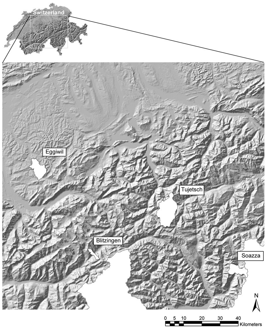
We selected four municipalities, Tujetsch, Eggiwil, Soazza and Blitzingen (Fig. 1), which gave a cross-section of the agro-climatic, topographic and socio-economic conditions in the Swiss Alps. Natural reforestation of sub-alpine grasslands has occurred at all sites, as indicated by the recent Swiss land-use statistics (SFSO, 2001). Table 1 summarises the land-use/land-cover and socio-economic characteristics of each municipality.
我们选择了Tujetsch、Eggiwil、Soazza和Blitzingen 4个市镇(图1),它们涵盖了瑞士阿尔卑斯山区不同的农业气候、地形和社会经济条件。瑞士最新土地利用统计表明,所有研究地点均发生了亚高山草地的自然再造林(SFSO, 2001)。表1汇总了各市镇的土地利用/土地覆被及社会经济特征。
Tujetsch (134 km2), consists of several small villages with an average altitude of 1450 m. The mean annual temperature of agricultural areas (including alpine areas) ranges from �2.5 �C to 5.2 �C (from 5.2 �C to 13.8 �C in July) and the mean annual precipitation ranges from 1194 mm to 1702 mm. As in the other three municipalities, livestock farming (cattle, sheep and goats) is the most common form of agriculture and managed pasture is the dominant land-use. Tujetsch is characterised by a relatively high proportion of alpine pastures (22%), which occur at
Tujetsch(134 km2)由若干小村庄组成,平均海拔1450 m。农业区(包括高山区)的年平均气温为−2.5 °C至5.2 °C(7月为5.2 °C至13.8 °C),年平均降水量为1194 mm至1702 mm。与其他3个市镇一样,畜牧业(牛、绵羊和山羊)是最普遍的农业形式,经营性牧场是主要的土地利用类型。Tujetsch的特点是高山牧场所占比例较高(22%),这些牧场分布于
Characteristicsa of the case study municipalities compared to Switzerland (CH)案例研究市镇与瑞士全国(CH)的特征a比较
| CH | TujetschTujetsch | EggiwilEggiwil | SoazzaSoazza | BlitzingenBlitzingen | |
|---|---|---|---|---|---|
| Land-use/land-coverb | |||||
| Shrubs (%) | 1.5 | 4.5 | 0.0 | 2.6 | 2.9 |
| Closed forest (%) | 26.7 | 5.5 | 36.8 | 47.3 | 19.8 |
| Agriculture without alpine pastures (%) | 23.9 | 3.7 | 41.5 | 1.0 | 8.4 |
| Alpine pastures (%) | 13.0 | 22.0 | 13.0 | 6.2 | 28.3 |
| Unproductive area/other (%) | 34.9 | 64.2 | 8.7 | 42.8 | 40.6 |
| Socio-economic conditions | |||||
| Population change 1950–2000 (%) | 54.6 | 35.9 | �6.6 | 3.2 | �45.0 |
| Employees in the primary sector 2000 (%) | 3.3 | 4.0 | 25.5 | 5.5 | 4.1 |
| Proportion of fulltime farms 2000 (%) | 69.8 | 65.7 | 71.3 | 27.3 | 100.0 |
| Number of farms 1939 | 238,481 | 183 | 335 | 65 | 35 |
| Number of farms 1990 | 108,296 | 62 | 288 | 18 | 4 |
| Decrease of farms 1939–1990 (%) | 54.6 | 66.1 | 14.0 | 72.3 | 88.6 |
| Average farm size 2001 (ha) | 15.6 | 13.1 | 13.5 | 6.7 | 22.0 |
a Data were taken from a digital elevation model provided by the Swiss Federal Office of Topography, Swiss climate station data (Normals 1961–1990), Swiss land-use statistics (1992/1997), and population and agricultural censuses provided by the Swiss Federal Statistical Office. b In % of the total area.
a 数据来源于瑞士联邦地形局提供的数字高程模型、瑞士气象站数据(1961–1990年气候标准值)、瑞士土地利用统计(1992/1997)以及瑞士联邦统计局提供的人口与农业普查。b 占总面积的百分比。
and above the treeline (ca. 2200 m). Grazing occurs during summer. While the number of farms has decreased from 183 to 62 during the past half century, the population has increased by 36%. Tourism and the construction site of the New Alpine Transversal (NEAT, currently the world’s largest railway tunnel) are the largest employers.
林线(约2200 m)及其以上区域。放牧在夏季进行。过去半个世纪中,农场数量由183个减少至62个,而人口增加了36%。旅游业以及新阿尔卑斯铁路干线(NEAT,目前世界上最长的铁路隧道)建设工地是最大的就业来源。
Eggiwil (size 60 km2) lies at an altitude of 729 m. The mean annual temperature of agricultural areas ranges from 4.4 �C to 7.8 �C (from 13.1 �C to 17.0 �C in July), the mean annual precipitation ranges from 1360 mm to 1961 mm. The topography is characterised by flat valley bottoms with steep flanks. Eggiwil is the only selected municipality that lies entirely below the treeline. Compared to the other municipalities, the Eggiwil’s agricultural land (54% including alpine pastures) has more favourable agro-climatic and topographic conditions. The population decreased (by 6% between 1950 and 2000), as did the number of farms (from 335 to 288 between 1939 and 1990). Agriculture is still an important employer as indicated by the 25% employees working in the primary sector (Table 1).
Eggiwil(面积60 km2)海拔729 m。农业区年平均气温为4.4 °C至7.8 °C(7月为13.1 °C至17.0 °C),年平均降水量为1360 mm至1961 mm。其地形特点为平坦的谷底和陡峭的谷坡。Eggiwil是所选市镇中唯一完全位于林线以下的市镇。与其他市镇相比,Eggiwil的农业用地(含高山牧场占54%)具有更有利的农业气候和地形条件。人口有所减少(1950–2000年间减少6%),农场数量亦然(1939–1990年间由335个减至288个)。农业仍是重要的就业部门,25%的就业人员从事第一产业即为佐证(表1)。
Soazza (46 km2) lies at an altitude of 626 m. The mean annual temperature of agricultural areas ranges from 1.0 �C to 10.6 �C (from 9.3 �C to 19.9 �C in July), the mean annual precipitation ranges from 1496 mm to 1747 mm. While parts of the municipality above the treeline have unfavourable agro-climatic conditions, the valley floor has a Mediterranean-type climate. This results in vegetation that is distinct from the other municipalities. Chestnut-trees (Castanea sativa) are ubiquitous in Soazza but are absent in the other municipalities where Norway spruce (Picea abies) and birch (Betula pendula) predominate. The low proportion of agricultural land (7%) and high proportion of forest and shrubs (50%) reflect unfavourable topographic conditions. The population remained approximately stable during the study period, while the number of farms decreased from 65 to 18 between 1939 and 1990. Many people in Soazza work in the nearby cities of Bellinzona and Lugano, which are tourism and industry hubs in southern Switzerland.
Soazza(46 km2)海拔626 m。农业区年平均气温为1.0 °C至10.6 °C(7月为9.3 °C至19.9 °C),年平均降水量为1496 mm至1747 mm。该市镇林线以上部分的农业气候条件不利,而谷底则为地中海型气候,因此其植被与其他市镇明显不同。欧洲栗(Castanea sativa)在Soazza随处可见,但在其他市镇则没有分布,那里以欧洲云杉(Picea abies)和垂枝桦(Betula pendula)为主。农业用地比例低(7%)而森林和灌木比例高(50%),反映了不利的地形条件。研究期内人口大致保持稳定,而农场数量在1939–1990年间由65个减少至18个。Soazza的许多居民在附近的贝林佐纳和卢加诺工作,这两座城市是瑞士南部的旅游和工业中心。
Blitzingen (12 km2) lies at an altitude of 1290 m. The mean annual temperature of the agricultural areas ranges from �2.0 �C to 5.5 �C (from 6.2 �C to 14.6 �C in July), the mean annual precipitation ranges from 1393 mm to 2258 mm. Blitzingen has the highest proportion of alpine pastures (28%) of the three municipalities. The population decreased by 45% between 1950 and 2000. In addition, the decrease of the number of farms was higher than in the other three municipalities (from 35 to 4 between 1939 and 1990). Due to its location at the end of a mountain pass, the job supply varies with season. The locals only receive reasonable incomes from the traffic and weekend tourism in the summer, when the pass is open.
Blitzingen(12 km2)海拔1290 m。农业区年平均气温为−2.0 °C至5.5 °C(7月为6.2 °C至14.6 °C),年平均降水量为1393 mm至2258 mm。在各市镇中,Blitzingen的高山牧场比例最高(28%)。1950–2000年间人口减少了45%。此外,其农场数量的减少幅度也高于其他3个市镇(1939–1990年间由35个减至4个)。由于地处山口的尽头,当地的就业机会随季节变化。当地居民仅在夏季山口开放时才能从过境交通和周末旅游中获得较为可观的收入。
2.2. Data preparation2.2 数据准备
The binary response variable used in the classification trees refers to the presence/absence of natural reforestation of agricultural land. It was derived from black and white (BW) aerial photographs taken between in the 1950s and 1960s and true colour (RGB) aerial photographs taken between 1998 and 2000 (Table 2). Aerial photographs were ortho-rectified to allow for overlay and comparison. The geometric accuracy between the BW and RGB images was determined by the root-mean-square error (RMSE). To calculate the RMSE, we compared the location of 10 checkpoints placed on each BW image with the location of the same checkpoints on the respective RGB image. The RMSEs were between 3.02 m and 5.12 m (Table 2), which was appropriate for the analyses because the raster cells used for land-use classifications and spatial modelling were 25 m.
分类树所用的二元响应变量为农业用地自然再造林的发生/未发生。该变量来源于1950年代和1960年代拍摄的黑白(BW)航空像片以及1998–2000年间拍摄的真彩色(RGB)航空像片(表2)。航空像片经过正射校正,以便叠加和比较。BW与RGB影像之间的几何精度采用均方根误差(RMSE)确定。为计算RMSE,我们将每幅BW影像上布设的10个检查点的位置与相应RGB影像上同一检查点的位置进行比较。RMSE介于3.02 m至5.12 m之间(表2),由于用于土地利用分类和空间建模的栅格单元为25 m,该精度可满足分析要求。
Irwin and Geoghegan (2001) suggested that land-use/ land-cover changes and its determinants should be investigated at the parcel level, where properties are clearly distinguishable. Other authors point out that land-cover changes are often not restricted to parcel boundaries and sub-parcel representation of land-cover is preferable (e.g. Brown et al., 2000). In this study, data on the parcel level were incomplete or not available for the 50-year study period, and we were primarily interested in land-use/land-cover changes at the sub-parcel level. Thus, we followed the suggestions by Brown et al. (2000) and used raster cells as the units of observation. Using sub-parcel representations of land-use/land-use changes minimises problems related to the parcel–pixel mismatch, which occur if the size of raster cells/pixels exceeds the size of parcels (Sherbinin et al., 2002).
Irwin and Geoghegan(2001)建议在宗地尺度上研究土地利用/土地覆被变化及其驱动因素,因为在该尺度上产权界线清晰可辨。另一些作者则指出,土地覆被变化往往不局限于宗地边界,亚宗地尺度的土地覆被表达更为可取(如Brown et al., 2000)。本研究中,50年研究期内的宗地尺度数据不完整或无法获得,且我们主要关注亚宗地尺度上的土地利用/土地覆被变化。因此,我们遵循Brown et al.(2000)的建议,采用栅格单元作为观测单位。采用亚宗地尺度表达土地利用/土地利用变化,可最大限度地减少宗地–像元不匹配问题,该问题在栅格单元/像元尺寸大于宗地尺寸时出现(Sherbinin et al., 2002)。
For land-use classifications, ortho-images were overlaid with a raster with 25 m cell size. Raster cell size corresponds to the resolution of the digital elevation model that provided the basis for the calculation of most of the explanatory variables (see Table 3). To reduce spatial dependence in the presence/absence data, we followed suggestions by Munroe et al. (2002) and classified a regular sample of raster cells for model building. We sampled every fifth raster cell in x- and y-direction from the raster. To facilitate comparisons of model results, the distance between raster cells was equal in all municipalities. This distance should be as large as possible to minimise spatial dependence (see Munroe et al., 2002). At the same time, the smallest sample should enclose an adequate number of raster cells for classification tree building. In Soazza, i.e. the municipality with the smallest number of presence/ absence observations, we had 148 raster cells available after sampling and classification, which is an adequate sample size to fit a classification tree (see Therneau and Atkinson, 2006).
进行土地利用分类时,将正射影像与单元尺寸为25 m的栅格叠加。栅格单元尺寸与数字高程模型的分辨率一致,而大多数解释变量的计算均以该模型为基础(见表3)。为降低发生/未发生数据的空间依赖性,我们遵循Munroe et al.(2002)的建议,对栅格单元进行规则抽样以用于模型构建,即在栅格的x和y方向上每隔5个单元抽取1个。为便于比较模型结果,所有市镇中栅格单元之间的间距均相同。该间距应尽可能大,以最大限度地降低空间依赖性(见Munroe et al., 2002);同时,最小样本也应包含足够数量的栅格单元以构建分类树。在发生/未发生观测数最少的市镇Soazza,经抽样和分类后可用栅格单元为148个,这一样本量足以拟合分类树(见Therneau and Atkinson, 2006)。
Evaluation years of the black and white (BW) and true colour (RGB) aerial photographs
黑白(BW)和真彩色(RGB)航空像片的判读年份
| TujetschTujetsch | EggiwilEggiwil | SoazzaSoazza | BlitzingenBlitzingen | |
|---|---|---|---|---|
| Evaluation years of BW aerial | 1959 | 1953/ | 1961/ | 1960/ |
| photos | 1954 | 1962 | 1961 | |
| Evaluation years of RGB | 2000 | 1998 | 1999 | 1999/ |
| aerial photos | 2000 | |||
| RMSE between BW and RGB images (m) | 3.02 | 3.39 | 5.12 | 3.87 |
The root-mean-square error (RMSE) measures the geometric accuracy between the BW and RGB images.
均方根误差(RMSE)用于衡量BW与RGB影像之间的几何精度。
Explanatory variables used in the classification trees with abbreviations as used in the text, variable units, spatial resolutions and data sources
分类树中所用的解释变量及其在正文中的缩写、变量单位、空间分辨率和数据来源
| Variable变量 | Abbrev.缩写 | Unit单位 | Resol.分辨率 | Sourcea来源a |
|---|---|---|---|---|
| Annual degree daysc | DDEG | (day�C) | 25 m | CSD/ DEM25 |
| Precipitation sumb,c | PREC | (1/10 mm/ month) | 25 m | CSD/ DEM25 |
| Potential direct shortwave radiationb,c | SDIR | (kJ/day) | 25 m | CSD/ DEM25 |
| Soil depth | SOILDEP | (cm) | 25 m | BEK200 |
| Slope | SLOPE | (�) | 25 m | DEM25 |
The following data sources were used. a DEM25: digital elevation model available as raster with 25 m cell size (source: Swiss Federal Office of Topography); CSD: Swiss climate station data (Normals) evaluated between 1961 and 1990; BEK200: soil suitability map at 1: 200,000 (‘‘Bodeneignungskarte der Schweiz’’). b The values were calculated as average of the growing season (May– September). c For details of variable calculation see Zimmermann and Kienast (1999).
所用数据来源如下。a DEM25:栅格单元尺寸为25 m的数字高程模型(来源:瑞士联邦地形局);CSD:1961–1990年瑞士气象站数据(气候标准值);BEK200:1:200,000土壤适宜性图(“Bodeneignungskarte der Schweiz”)。b 数值为生长季(5–9月)的平均值。c 变量计算的详细方法见Zimmermann and Kienast(1999)。
For each raster cell, we visually estimated the amount of land under agriculture and forest. A raster cell was classified as ‘agriculture’ if it showed P50% agricultural land-use. Likewise a raster cell was classified as ‘forest’ if it was >50% covered by trees and shrubs. The definitions of ‘agriculture’ and ‘forest’ are subjective; although the Swiss land-use statistics use similar thresholds to delineate agricultural land and forest (see BFS, 1992). Changes in land-use were determined by comparing classifications made for raster cells. Raster cells that changed from ‘agriculture’ to ‘forest’ are labelled ‘presence’ observations in this study. Likewise, raster cells that remained ‘agriculture’ are labelled ‘absence’ observations. Since reforestation does not occur above the treeline, we excluded these areas from the analysis. We estimated the treeline by determining the highest altitude in each municipality where trees and shrubs occurred on aerial photographs. Planned reforestation, which was distinguished from natural reforestation by means of interviews with the local foresters, afforestation maps and field work and land that could not clearly be classified as ‘agriculture’ and ‘forest’ were also excluded from the analysis.
对于每个栅格单元,我们目视估计了农业用地和森林的面积。若某栅格单元中农业用地≥50%,则归为“农业”;同样,若某栅格单元被树木和灌木覆盖的比例>50%,则归为“森林”。“农业”和“森林”的定义具有一定主观性,不过瑞士土地利用统计在划分农业用地和森林时也采用了类似的阈值(见BFS, 1992)。土地利用变化通过比较栅格单元的分类结果来确定。本研究将由“农业”转变为“森林”的栅格单元标记为“发生”观测,将保持为“农业”的栅格单元标记为“未发生”观测。由于林线以上不会发生再造林,我们将这些区域排除在分析之外。林线的估计方法是确定各市镇航空像片上出现树木和灌木的最高海拔。人工造林(通过访谈当地林务人员、造林图和野外调查与自然再造林相区分)以及无法明确归为“农业”或“森林”的土地也被排除在分析之外。
The explanatory variables used in the classification tree analyses (Table 3) were selected to prove the study hypothesis and are proxies for the cultivation costs and yield potential of agricultural land. To make the model results communicable to landowners and operators, we only used easily interpretable variables. Reforestation was considered to have occurred where the conditions were unfavourable for agricultural production, which was mostly on steep land with shallow soils, low temperature and shortage of precipitation. From a previous study conducted over the entire Swiss Alps (Gellrich et al., 2007), we also know that reforestation is limited near the treeline.
分类树分析所用的解释变量(表3)是为检验研究假设而选取的,代表农业用地耕作成本和产量潜力的替代指标。为使模型结果便于向土地所有者和经营者传达,我们仅采用易于解释的变量。我们认为再造林发生在农业生产条件不利的地方,主要是土层浅薄、温度低且降水不足的陡峭土地。根据此前在整个瑞士阿尔卑斯山区开展的研究(Gellrich et al., 2007),我们还知道林线附近的再造林受到限制。
We hypothesised that the distance to roads and farmhouses would influence land abandonment and reforestation because they affect transportation costs. However, investigating such effects in the classification trees was difficult because tenancies have changed. Many parcels have merged or were split, new roads and farmhouses were constructed, and means of transport have changed over the 50- year study period. We could not construct adequate distance related variables that consider all these different cases. Whether the accessibility is considered as ‘good’ or not also depends on the type of land-use (e.g. mowing or pasturing) and individual preferences. Some authors (e.g. Chomitz and Gray, 1996) report endogeneity problems with the distance to roads in statistical models. This is because the conditions of agricultural production often influence road location. To avoid incorrect inferences from distance related variables, only time invariant geo-physical explanatory variables were used to develop the classification trees. Possible effects of the accessibility of the land on the individuals’ land-use decisions were examined by interviews.
我们假设到道路和农舍的距离会影响土地弃耕与再造林,因为二者影响运输成本。然而,由于租佃关系发生了变化,在分类树中考察此类影响较为困难。在50年研究期内,许多宗地被合并或分割,新建了道路和农舍,交通方式也发生了变化。我们无法构建能够兼顾所有这些情形的合适距离变量。可达性是否被视为“良好”,还取决于土地利用类型(如刈割或放牧)和个人偏好。一些作者(如Chomitz and Gray, 1996)指出,统计模型中到道路的距离存在内生性问题,这是因为农业生产条件常常影响道路的选址。为避免基于距离变量得出错误推断,构建分类树时仅采用不随时间变化的地球物理解释变量。土地可达性对个人土地利用决策的可能影响则通过访谈加以考察。
2.3. Classification trees2.3 分类树
We used classification tree (CT) analysis to characterise the agro-climatic, topographic and soil characteristics of the sample of observations classified as ‘presence’ or ‘absence’. In a CT, a dataset is recursively partitioned into increasingly homogenous subsets called terminal nodes (Breiman et al., 1984). Each terminal node is assigned the label of the majority class (presence or absence of reforestation in this study). Splits defining how to partition the data were selected based on information statistics that measure how well the split decreases the heterogeneity of training data. The classification process starts at the root node (which encompasses the entire dataset) and ends at the terminal nodes. A developed CT encodes a set of decision rules in form of if–then-statements, which are analogous to the decisions made by individuals while managing their land.
我们采用分类树(CT)分析来刻画被归为“发生”或“未发生”的观测样本的农业气候、地形和土壤特征。在CT中,数据集被递归地划分为同质性不断增强的子集,称为终端节点(Breiman et al., 1984)。每个终端节点被赋予多数类的标签(本研究中为再造林发生或未发生)。数据划分的分裂规则依据信息统计量选取,该统计量衡量分裂在多大程度上降低了训练数据的异质性。分类过程始于根节点(包含整个数据集),止于终端节点。构建完成的CT以“如果–则”语句的形式编码一组决策规则,这类似于个人在管理土地时所做的决策。
CTs are usually pruned to avoid over-fitting, i.e. making it too sensitive to variation peculiar to the datasets used for model building. Pruning entails reducing the number of nodes to determine how the misclassification error rate changes as a function of tree size (Breiman et al., 1984). We used 10-fold cross-validation to find an optimal level of complexity for each CT (Venables and Ripley, 2002). We tested other forms of cross-validation, and found that the final form of our CTs was insensitive to the form of cross-validation. CTs were built and pruned using the library section rpart (Therneau and Atkinson, 2006) available in the R statistics software (R Development Core Team, 2006).
CT通常需要剪枝以避免过拟合,即避免其对建模数据集特有的变异过于敏感。剪枝通过减少节点数量来确定误分类率随树规模变化的规律(Breiman et al., 1984)。我们采用10折交叉验证确定每棵CT的最优复杂度(Venables and Ripley, 2002)。我们还测试了其他形式的交叉验证,发现CT的最终形式对交叉验证的形式不敏感。CT的构建和剪枝采用R统计软件(R Development Core Team, 2006)中的rpart程序库(Therneau and Atkinson, 2006)完成。
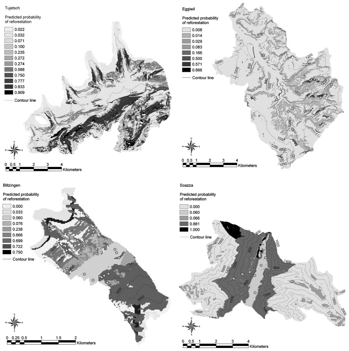
CT model predictions are based on the proportion of observations of presence and absence at a terminal node (Miller and Franklin, 2002). The proportion of ‘presence’ indicates a probability that is analogous to the probability of presence in logistic regression models (see Hosmer and Lemeshow, 2000). Here, we translated the encoded decision rules of each tree into Arc-Macro-Language (AML) code and ran the code using ArcInfo� procedures to obtain raster maps containing the probability that agriculture land reverts to forest in each raster cell.
CT模型的预测基于终端节点中发生与未发生观测的比例(Miller and Franklin, 2002)。“发生”的比例表示一种概率,类似于logistic回归模型中的发生概率(见Hosmer and Lemeshow, 2000)。本研究将每棵树所编码的决策规则转换为Arc宏语言(AML)代码,并利用ArcInfo®程序运行该代码,得到包含各栅格单元中农业用地转变为森林概率的栅格图。
Prediction accuracy was measured by the AUC = ‘‘area under the receiver operating characteristic (ROC) curve’’ (Metz, 1978) based on an independent dataset. An ROC plot is obtained by plotting sensitivity values (=fraction of observed ‘present’ correctly predicted) on the y-axis against 1 – specificity values (specificity = fraction of observed ‘absent’ correctly predicted) on the x-axis for a range of probability thresholds (Miller and Franklin, 2002). The AUC provides a measure of overall model accuracy based on different probability thresholds. AUC values close to 0.5 indicate low similarity between the observed and predicted values, whereas values close to 1.0 indicate high similarities between the observed and predicted values. According to Hosmer and Lemeshow (2000), AUC values from >0.8 are excellent and those >0.9 are outstanding.
预测精度基于独立数据集,采用AUC即“受试者工作特征(ROC)曲线下面积”(Metz, 1978)进行衡量。ROC曲线是在一系列概率阈值下,以灵敏度(即被正确预测的观测“发生”所占比例)为y轴、1 – 特异度(特异度即被正确预测的观测“未发生”所占比例)为x轴绘制而成(Miller and Franklin, 2002)。AUC基于不同概率阈值提供了模型总体精度的度量。AUC值接近0.5表明观测值与预测值相似性低,而接近1.0则表明二者相似性高。根据Hosmer and Lemeshow(2000),AUC值>0.8为优秀,>0.9为杰出。
2.4. Preparation of interviews2.4 访谈准备
Following the ‘‘finding answers in the errors’’ approach proposed by Wood and Skole (1998), fitted CTs provided the basis for interviews. Conceptually, this approach comprises of three steps. Firstly, a spatial statistical model is calibrated to replicate the actual pattern of land-use/land-use change. Secondly, model predictions are compared with the actual land-use/land-use changes and variations between the predicted and the actual land-use/land-use changes are identified. Thirdly, additional data are surveyed in the field to identify possible causes of model misspecifications and spurious associations. The latter occur if the relationships between variables found in the model indicate ‘true’ causality, although unmeasured factors – which are not included into the model, but related to the variables in the model – are the true causes of the observed land-use/land-cover changes (Wood and Skole, 1998).
按照Wood and Skole(1998)提出的“在误差中寻找答案”方法,以拟合的CT作为访谈的基础。从概念上讲,该方法包括3个步骤:首先,校准空间统计模型以再现土地利用/土地利用变化的实际格局;其次,将模型预测与实际土地利用/土地利用变化进行比较,识别预测与实际变化之间的差异;再次,在野外调查补充数据,以识别模型设定偏误和伪相关的可能原因。当模型中发现的变量间关系看似表明“真实”因果关系,而实际上未测量的因素(未纳入模型但与模型中变量相关)才是所观测到的土地利用/土地覆被变化的真正原因时,便会出现伪相关(Wood and Skole, 1998)。
Wood and Skole (1998) proposed the use of regression residuals to select some observations representing ‘‘outliers’’ and which fall ‘‘along (or close to) the regression line’’ and collect additional information for these observations in the field. In the CTs, the probability of a particular observation becoming abandoned and overgrown was estimated, while in the actual event, either an observation was abandoned and overgrown or not. Thus, there is no clear way of calculating residuals to compare predicted value versus actual value. In addition, as the prediction results in a probability that ranges from 0 to 1.0 (in theory) we needed to determine the critical value of the probability that an observation ‘counts’ as an abandoned or unabandoned observation.
Wood and Skole(1998)提出利用回归残差选取一些代表“离群值”以及落在“回归线上(或其附近)”的观测,并在野外收集这些观测的补充信息。在CT中估计的是某一观测被弃耕并被植被覆盖的概率,而实际情况中某一观测要么被弃耕并被覆盖,要么没有。因此,没有明确的方法计算残差来比较预测值与实际值。此外,由于预测结果为(理论上)介于0至1.0之间的概率,我们需要确定将某一观测“计为”弃耕或未弃耕观测的概率临界值。
Often researchers take 0.5 as the threshold to consider a predicted probability value to be a ‘correctly’ or ‘incorrectly’ predicted observation. However, Geoghegan et al. (2001) criticised this ad hoc choice of a threshold. We make no absolute assumptions about correctly or incorrectly predicted observations. Instead, we were interested in similarities and deviations between the actual land-use/land-use changes and corresponding CT predictions. Model deviations are not regarded as ‘‘errors’’ per se, but as indicators of local peculiarities related to the cultivations costs and benefits of land-use. To identify similarities and deviations between the actual land-use/land-use changes and model predictions, we systematically selected sites in the field (henceforth ‘interview sites’) by visually comparing the actual ‘presence’ and ’absence’ with the corresponding CT predictions. The minimum size of one interview site corresponded to the size of the raster cells used for model building (i.e. 625 m2). One interview site could also include multiple cells, provided that they were of the same type (for site types see Table 4), adjacent, and belonged to the common parcel and owner, respectively. We selected interview sites based on the 2 · 2 classification matrix shown in Table 4.
研究人员通常以0.5作为阈值,判断某一预测概率值对应的是“正确”还是“错误”预测的观测。然而,Geoghegan et al.(2001)批评了这种阈值的随意选取。我们对正确或错误预测的观测不作绝对假设,而是关注实际土地利用/土地利用变化与相应CT预测之间的相似与偏差。模型偏差本身并不被视为“误差”,而是被视为与土地利用的耕作成本和收益相关的地方特殊性的指示。为识别实际土地利用/土地利用变化与模型预测之间的相似与偏差,我们通过目视比较实际的“发生”和“未发生”与相应的CT预测,在野外系统地选取了地块(以下称“访谈地块”)。一个访谈地块的最小面积与建模所用栅格单元的面积一致(即625 m2)。一个访谈地块也可包含多个单元,前提是这些单元属于同一类型(地块类型见表4)、相互毗邻,并分别属于同一宗地和同一所有者。我们根据表4所示的2 × 2分类矩阵选取访谈地块。
Whether the predicted probability was ‘low’ or ‘high’ (Table 4), depended on the range of probability values of each model and the availability of observations. In Tujetsch, for example, the predicted probabilities ranged from 0 to 0.91. We selected interview sites for (II) and (III) where the probability was 0.91. Where we could not find sites for (II) and (III) at predicted probabilities of 0.91 (e.g. because all sites showing these probabilities were forest in the 1950s/1960s), we took the next lowest predicted probability to select interview sites (in this example 0.83). We repeated this procedure until we found appropriate sites for (II) and (III). Likewise, sites for (I) and (IV) were selected where the probability was close to 0. This approach is similar to the selection of ‘‘outliers’’ and observations that ‘‘fall along (or close to) the regression line’’ as proposed by Wood and Skole (1998) as it takes well-modelled sites (here I and II) and potential model misspecifications (here III and IV) into account.
预测概率属于“低”还是“高”(表4),取决于各模型概率值的范围以及可用观测的情况。例如,在Tujetsch,预测概率介于0至0.91之间。我们在概率为0.91处选取(II)类和(III)类访谈地块。若在预测概率为0.91处找不到(II)类和(III)类地块(例如,因为所有具有该概率的地块在1950年代/1960年代均为森林),则取次低的预测概率(本例中为0.83)选取访谈地块。重复这一过程,直至找到合适的(II)类和(III)类地块。同样,(I)类和(IV)类地块选取于概率接近0处。该方法与Wood and Skole(1998)提出的选取“离群值”和落在“回归线上(或其附近)”观测的方法相似,因为它同时兼顾了模拟良好的地块(此处为I类和II类)和潜在的模型设定偏误(此处为III类和IV类)。
Within each municipality we selected at least two sites for (I), (II), (III) and (IV). Some respondents had more than one interview site according to the classification
在每个市镇中,我们为(I)、(II)、(III)和(IV)类各选取了至少2个地块。根据分类
Classification matrix used to select interview sites用于选取访谈地块的分类矩阵
| Model predictions模型预测 | Observed from aerial pho航空像 | tographs片观测 |
|---|---|---|
| Cultivation maintained (absence) | Reforested (presence) | |
| Probability of reforestation low | I | IV |
| Probability of reforestation high | III | II |
matrix in Table 4. This is because we obtained a total of 48 interview sites. After selection, we obtained the landowners’ addresses from the local surveying and mapping office. We contacted landowners by mail, and then telephoned to arrange a meeting. We interviewed 31 landowners (18 fulltime farmers, 1 part-time farmer, 2 hobby farmers, 2 retired farmers and 8 non-farmers). For reforested sites and those under cultivation, we interviewed the landowners and farmers, respectively. Cases were a farmer had a plot that was partially reforested were considered if they were consistent with the classification scheme in Table 4. Such cases, however, were not interpreted separately. Interviews occurred between August 2004 and July 2005. We used semi-structured interviews based on pre-set topics that related to the personal information of respondents, characteristics of the interview sites, the motivation to abandon or maintain the cultivation, and the underlying causes of reforestation.
矩阵(表4),部分受访者拥有不止一个访谈地块,因此我们共获得48个访谈地块。选定后,我们从当地测绘部门获取了土地所有者的地址,先通过信函联系土地所有者,再电话约定会面。我们访谈了31位土地所有者(18位全职农民、1位兼业农民、2位业余农民、2位退休农民和8位非农民)。对于再造林地块和仍在耕作的地块,我们分别访谈了土地所有者和农民。若某农民拥有部分再造林的地块,且符合表4的分类方案,则将其纳入考虑,但此类情况不单独解释。访谈于2004年8月至2005年7月间进行。我们采用半结构式访谈,预设话题涉及受访者个人信息、访谈地块特征、弃耕或维持耕作的动机以及再造林的深层原因。
3Results结果
3.1. Model results3.1 模型结果
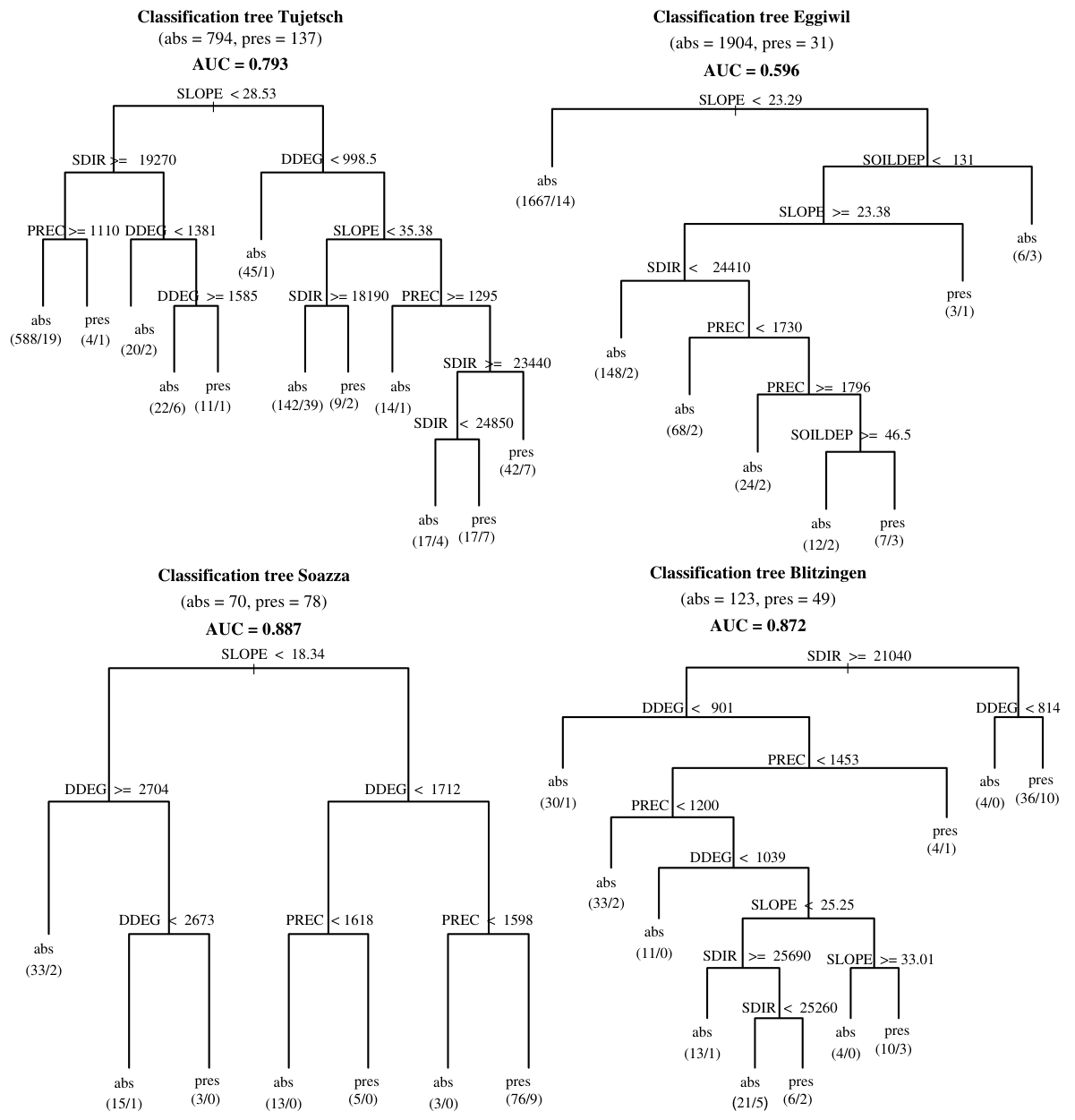
Fitted CTs encode a set of decision rules describing the geo-physical characteristics of the model sample of presence/absence observations. For example, the left most decision rule of the CT of Tujetsch (Fig. 2) can be translated: ‘‘if steepness (SLOPE) is <28.53 (�) and radiation (SDIR) is P19,270 (kJ/day) and precipitation (PREC) is P1110 (1/10 mm/month), then 588 observations occurred at this terminal node and 19 were presence’’. As the majority of observations at this node are absences, an absence (‘abs’) was assigned to this node. For predictive purposes, where the same geo-physical conditions exist throughout the unsampled parts of the study area, there is a 0.032 (19/ 588) probability of reforestation.
拟合的CT编码了一组决策规则,描述了发生/未发生观测模型样本的地球物理特征。例如,Tujetsch的CT(图2)最左侧的决策规则可表述为:“如果坡度(SLOPE)<28.53(°)、辐射(SDIR)≥19,270(kJ/day)且降水(PREC)≥1110(1/10 mm/month),则该终端节点有588个观测,其中19个为发生”。由于该节点的大多数观测为未发生,因此该节点被赋予未发生(“abs”)。就预测而言,在研究区未抽样部分中具有相同地球物理条件的地方,再造林概率为0.032(19/588)。
The explanatory variables in CTs were selected to create splits that maximise the resulting node homogeneity. Thus, the variables used in early splits (i.e. close to the root node) were considered more important for the explanations of reforestation than variables in later splits, i.e. those close to the terminal nodes (see Miller and Franklin, 2002). The CTs for Tujetsch, Eggiwil and Soazza used steepness (SLOPE) for the first split. This indicated that the steepness of slopes is the factor with the largest influence on the land-use decisions of land operators. The CT for Blitzingen used radiation (SDIR) for the first split, which indicated an influence of the slope aspect on the land-use decisions of landowners in Blitzingen.
CT中的解释变量是为形成使所得节点同质性最大化的分裂而选取的。因此,早期分裂(即靠近根节点)所用的变量被认为比后期分裂(即靠近终端节点)所用的变量对解释再造林更为重要(见Miller and Franklin, 2002)。Tujetsch、Eggiwil和Soazza的CT均以坡度(SLOPE)作为第一次分裂变量,表明坡度是对土地经营者土地利用决策影响最大的因素。Blitzingen的CT以辐射(SDIR)作为第一次分裂变量,表明坡向对Blitzingen土地所有者的土地利用决策具有影响。
The AUC value provided in the head of each CT (Fig. 2) measures the prediction accuracy based on an independent dataset. The CTs of Soazza (AUC = 0.887), Blitzingen (AUC = 0.872) and Tujetsch (AUC = 0.793) predict the corresponding independent datasets well. This indicates that the explanatory variables included in these models represent the most important geo-physical factors influencing land-use decisions. The prediction accuracy of the CT of Eggiwil is comparably weak (0.596).
每棵CT顶部给出的AUC值(图2)衡量了基于独立数据集的预测精度。Soazza(AUC = 0.887)、Blitzingen(AUC = 0.872)和Tujetsch(AUC = 0.793)的CT对相应独立数据集的预测效果良好,表明这些模型所包含的解释变量代表了影响土地利用决策的最重要地球物理因素。Eggiwil的CT预测精度相对较弱(0.596)。
The ratio of the presence/absence observations was used to estimate the quantity of reforestation in each municipality. In Tujetsch, 794 observations representing absence and 137 observations representing presence of reforestation were available (Fig. 2), indicating 15% of the sample of observations altered from agriculture to forest. Soazza and Blitzingen had the highest reforestation rates (53% and 28%, respectively) of the four municipalities, while Tujetsch had a moderate reforestation rate (15%). In Eggiwil, reforestation occurred only sporadically (1%).
我们利用发生/未发生观测的比例估算各市镇的再造林数量。在Tujetsch,有794个观测为再造林未发生,137个观测为发生(图2),表明15%的样本观测由农业转变为森林。在4个市镇中,Soazza和Blitzingen的再造林率最高(分别为53%和28%),Tujetsch的再造林率中等(15%),而Eggiwil的再造林仅零星发生(1%)。
Visual comparisons of CT predictions (Fig. 3) with aerial photographs showed that the predicted probability of reforestation was higher on steep slopes and lower on gentle slopes and land close to the valley floor. With increasing altitude, the probability of reforestation decreased, irrespective of the topographic conditions, which showed that the CTs correctly predicted the decrease in forest re-growth in areas approaching the treeline. In Blitzingen, reforestation occurred mostly on the north-facing part of the municipality, which underlined the importance of radiation in the corresponding CT.
将CT预测(图3)与航空像片进行目视比较表明,陡坡上的再造林预测概率较高,而缓坡和靠近谷底的土地则较低。随着海拔升高,无论地形条件如何,再造林概率均降低,这表明CT正确预测了接近林线区域森林恢复的减少。在Blitzingen,再造林主要发生在市镇朝北的部分,这凸显了辐射在相应CT中的重要性。
3.2. Linking individuals and models3.2 个人与模型的关联
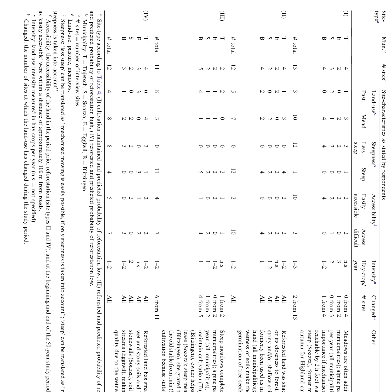
Site-characteristics as stated by respondents are summarised in Table 5 and described below.
受访者陈述的地块特征汇总于表5,并描述如下。
For sites on which cultivation has been maintained, and the predicted probability of reforestation was low (category I in Table 4), models accurately predicted the agro-climatic, soil and topographic conditions as suitable for agricultural production (Table 5). Most of these sites (10 out of 13) are mowed meadows; 12 sites were characterised as less steep; 10 sites were characterised as easily accessible in the past. Two sites were under pasture. The herdsmen of one site stated that there was no road and that the pasture is only accessible by a 2 h walk. However, he considered the land favourable for pasturing because it was less steep. In Soazza and Tujetsch, some of the sites suitable for mechanised mowing were used as pastures for Highland cattle.
对于维持耕作且再造林预测概率低的地块(表4中的I类),模型准确地预测其农业气候、土壤和地形条件适宜农业生产(表5)。这些地块中大多数(13个中的10个)为刈割草地;12个地块被描述为坡度较缓;10个地块被描述为过去易于到达。有2个地块用作牧场。其中一个地块的牧人表示,那里没有道路,只能步行2 h到达牧场,但由于坡度较缓,他认为该土地适宜放牧。在Soazza和Tujetsch,一些适宜机械化刈割的地块被用作高地牛的牧场。
For reforested sites with a high predicted probability of reforestation (category II in Table 4), models accurately predicted the agro-climatic, soil and topographic conditions as less suitable for agricultural production (Table 5). All of these sites (12) were characterised as steep; 10 sites were characterised as difficult to access in the past. Some of these sites were additionally characterised as shady because north-exposed and/or close to forest edges or respondents mentioned that the soils are shallow, wet or stony. Seven sites were formerly used as meadows, whereas respondents stated that, in the past, this land had to be mowed by hand due to the steepness of slopes; five sites were formerly under pasture.
对于再造林预测概率高的再造林地块(表4中的II类),模型准确地预测其农业气候、土壤和地形条件不太适宜农业生产(表5)。所有这些地块(12个)均被描述为陡峭;10个地块被描述为过去难以到达。其中一些地块还因朝北和/或靠近林缘而被描述为背阴,或受访者提到其土壤浅薄、潮湿或多石。7个地块过去用作刈割草地,但受访者表示,由于坡度陡峭,过去这些土地只能人工刈割;另有5个地块过去用作牧场。
Sites where the cultivation has been maintained and the predicted probability of reforestation was high (category III in Table 4) indicate model misspecifications. Most of these sites (8 out of 11) were under pasture. At four of these sites, farmers stated no specific causes for the maintenance of cultivation, but pointed out that the land was relatively steep. For seven sites, we found explanations for the maintenance of cultivation. One of these sites (in Tujetsch) is an agricultural compensation area for which the owner is obliged to maintain cultivation. The farmer stated that he had brought the land into production after it lay fallow for several years and that he obtained additional payments from the owner – otherwise he would not cultivate this land. One site in Eggiwil, was mowed by a small winchdrawn mower. The farmer stated that this was common practice in the past but that only a few farmers use this technique today. A farmer in Soazza stated that he cultivates the land because agricultural politics regulates the maximum number of cattle per hectare and he did not have enough favourable land to keep as much cattle as he wanted. He also mentioned that he paid no rent for this land and the owner helped to make hay – otherwise he would not have cultivated it. Another landowner in Soazza stated that he mowed the land for many years just to prevent reforestation and keep the old stable from ruin. Farmers brought two sites in Blitzingen into production after they lay fallow for many years. These farmers stated that they experimented with alternative agriculture such as deer and horse pasturing. They invested much time to clear the land from trees and shrubs and stated that the professional farmers had no interest in cultivating this land. A former agricultural site in Blitzingen is now part of a summer residence. The owner stated that he mowed the land to prevent reforestation.
维持耕作但再造林预测概率高的地块(表4中的III类)表明存在模型设定偏误。这些地块中大多数(11个中的8个)用作牧场。在其中4个地块,农民没有说明维持耕作的具体原因,但指出该土地相对陡峭。对于7个地块,我们找到了维持耕作的解释。其中一个地块(位于Tujetsch)是农业生态补偿区,所有者有义务维持耕作。该农民表示,这块地休耕数年后由他重新投入生产,且他从所有者处获得额外报酬,否则他不会耕作这块地。Eggiwil的一个地块使用小型绞盘牵引式割草机刈割。该农民表示,这在过去是常见做法,但如今只有少数农民使用这种技术。Soazza的一位农民表示,他耕作这块地是因为农业政策规定了每公顷牛的最大数量,而他没有足够的优质土地来饲养他想要的牛群数量。他还提到,他无需为这块地支付租金,且所有者会帮忙晒制干草,否则他不会耕作这块地。Soazza的另一位土地所有者表示,他多年来刈割这块地只是为了防止再造林,并使旧畜棚免于破败。Blitzingen的两个地块在休耕多年后由农民重新投入生产。这些农民表示,他们尝试了放牧鹿和马等替代性农业,投入了大量时间清除土地上的树木和灌木,并表示专业农民对耕作这块地不感兴趣。Blitzingen的一处原农业用地现为一处夏季住所的一部分,其所有者表示,他刈割这块地是为了防止再造林。
Reforested sites showing low predicted probabilities of reforestation (category IV in Table 4) also indicate model misspecifications. Most of these sites (8 out of 12) were under pasture and characterised as less steep. We obtained explanations for the abandonment of cultivation for all sites. Respondents stated that the sites were abandoned because there were no roads in the past making accessibility difficult (5 sites) or the access was difficult due to the wetness of soils (2 sites). One respondent stated that land abandonment occurred because the grass was of low quality due to soil wetness. Two sites were abandoned because small trenches, holes in the ground and old stonewalls made mechanisation difficult. At one site, the respondent stated that cultivation was abandoned because the land was too dry due to shallow soils and that this dryness resulted in low hay yields.
再造林预测概率低的再造林地块(表4中的IV类)同样表明存在模型设定偏误。这些地块中大多数(12个中的8个)用作牧场,且被描述为坡度较缓。我们获得了所有地块弃耕的解释。受访者表示,这些地块被弃耕是因为过去没有道路,难以到达(5个地块),或因土壤潮湿而难以进入(2个地块)。一位受访者表示,弃耕是因为土壤潮湿导致牧草质量低下。2个地块被弃耕是因为小沟渠、地面坑洞和旧石墙使机械化作业困难。在1个地块,受访者表示弃耕是因为土层浅薄导致土地过于干旱,而这种干旱造成干草产量低。
3.3. Determinants of reforestation3.3 再造林的驱动因素
The interviews revealed similarities and differences between the four municipalities regarding the determinants of reforestation. For all four municipalities, farm structures changed as the result of the economic development during the study period. Of the 21 farmers, 14 stated that the farm size had increased, one stated that the farm size had decreased and six stated that the farm size remained unchanged. The number of livestock increased in 16 farms, decreased in one farm and remained unchanged in four farms. In two of the latter farms, farmers stated that only the composition of livestock has changed. The number of employees decreased in 10 farms, increased in 1 farm and
访谈揭示了4个市镇在再造林驱动因素方面的异同。在所有4个市镇中,农场结构均因研究期内的经济发展而发生了变化。在21位农民中,14位表示农场规模扩大,1位表示农场规模缩小,6位表示农场规模不变。16个农场的牲畜数量增加,1个农场减少,4个农场保持不变;在后者中的2个农场,农民表示仅牲畜构成发生了变化。10个农场的雇员数量减少,1个农场增加,
Summary characteristics of interview sites as stated by respondents受访者陈述的访谈地块特征汇总
remained stable in 10 farms. Farm sizes ranged from 22 ha to 40 ha in Tujetsch, from 5 ha to 77 ha in Eggiwil, from 3 ha to 44 ha in Soazza and from 7 ha to 44 ha in Blitzingen. In all four municipalities, respondents perceived the main determinants of reforestation were undergrazing and the cessation of the manual clearing of pastures from trees and shrubs, caused by farm labour shortages. Here, we summarise the perceptions of respondents regarding the determinants of reforestation.
10个农场保持稳定。农场规模在Tujetsch为22 ha至40 ha,在Eggiwil为5 ha至77 ha,在Soazza为3 ha至44 ha,在Blitzingen为7 ha至44 ha。在所有4个市镇中,受访者认为再造林的主要驱动因素是农业劳动力短缺所导致的放牧不足以及停止人工清除牧场上的树木和灌木。以下概述受访者对再造林驱动因素的看法。
In Tujetsch, the construction of hydroelectric power stations, roads and railways, and the growing importance of the tourism from the 1960s on, brought many new jobs and led to considerable migration of farm labour. This led to farm abandonment. At the end of the study, many farms had reached their maximum size and farmers stated that labour, rather than land was limiting. Thus, where agro-climatic and topographic conditions were unfavourable, trees and shrubs colonised the land. Free grazing, a common practice up to the 1960s, was subsequently forbidden. This forced farmers to fence in their livestock. Interviewees reported that fencing, in combination with a decreased number of goats that formerly cleaned pastures from trees and shrubs, was another important determinant of reforestation. Some new farmers joined the local farming community. We distinguished two cases: Firstly, children of former farmers who left their jobs and returned to take over their parents’ farm and, secondly, career changers from urban areas who took over the farm of retired farmers without a successor.
在Tujetsch,水电站、道路和铁路的建设以及自1960年代起旅游业重要性的日益增长,带来了大量新的就业机会,导致农业劳动力大量外流,进而造成农场弃耕。研究期末,许多农场已达到其最大规模,农民表示限制因素是劳动力而非土地。因此,在农业气候和地形条件不利的地方,树木和灌木侵占了土地。自由放牧在1960年代以前是普遍做法,此后被禁止,迫使农民将牲畜圈养在围栏内。受访者表示,围栏放牧加之过去负责清除牧场树木和灌木的山羊数量减少,是再造林的另一个重要驱动因素。一些新农民加入了当地农业社区,可分为两种情况:一是原农民的子女辞去工作后返乡接管父母的农场;二是来自城市地区的转行者接管了无继承人的退休农民的农场。
In Eggiwil, agriculture is still an important employer and respondents stated that land is scarce. Land from farms without successors was distributed among the remaining farms. This explains the low quantity of reforested land. Reforestation was mainly the result of the undergrazing of alpine pastures. Dairy cattle often grazed on farm pastures and were not brought to the alpine pastures, as was common practice in the past. Although reforestation occurred only sporadically, many respondents were sensitive about this topic. This is because the Federal Office for Agriculture recently updated the delineation of agricultural land to prevent the subsidisation of already reforested land. In the past, such cases of abuse provoked public criticism. The subsequent decrease of farm areas had led to a significant loss of income for some of the interviewed farmers.
在Eggiwil,农业仍是重要的就业部门,受访者表示土地稀缺。无继承人农场的土地被分配给其余农场,这解释了再造林土地数量较少的原因。再造林主要是高山牧场放牧不足的结果。奶牛常在农场牧场上放牧,而不再像过去通常那样被赶到高山牧场。尽管再造林仅零星发生,许多受访者对这一话题较为敏感,这是因为联邦农业局最近更新了农业用地的划定范围,以防止对已再造林的土地发放补贴。过去,此类滥用补贴的情况曾引发公众批评。随之而来的农场面积减少已导致部分受访农民收入大幅下降。
Soazza lies near the cities of Bellinzona and Lugano, which are centres of industry and tourism in Southern Switzerland. This proximity allows people reside in Soazza and commute to the larger cities, taking advantage of lower taxes. The lack of well-paid farm jobs and unfavourable conditions for agriculture (steep slopes, fragmented ownership structure due to hereditary customs), led to farm labour migration and farm abandonment. Another important determinant of reforestation that respondents reported was the delay of land consolidation. This process, which originally aimed to improve the fragmented structure of agricultural land, took more than 30 years (from the 1960s to the 1990s). As the result of the uncertain land tenure during this period, many agricultural areas (mostly on the Mont Grand, a mountain side of 50 ha size close to the village) were abandoned. Only occasionally, when landowners used old stables and surrounding land as summer residences, was reforestation prevented on Mont Grand. The reconstruction of old stables for summer residences is forbidden because old stables in this region, contrary to other regions in the Swiss mountains, have traditionally no space for farmers to stay overnight. According to one respondent, this regulation has depressed land prices and has led to the reforestation of much of the land. Some respondents linked farm abandonment to regulations concerning animal welfare discouraging farmers to invest in new stables. At the end of the study, many hobby farmers were cultivating land that was unattractive for professional farmers. Some of the owners raise no lease and may even pay to make hay to prevent the land from reforestation.
Soazza邻近Bellinzona和Lugano两座城市,二者是瑞士南部的工业和旅游中心。这种邻近关系使人们可以居住在Soazza并通勤至较大城市,从而享受较低的税负。由于缺乏收入较高的农业岗位,加之农业生产条件不利(坡度陡峭,以及因继承习俗而导致的土地权属结构破碎),农业劳动力外流,农地遭到弃耕。受访者报告的另一重要造林影响因素是土地整理的延迟。这一进程原本旨在改善农业用地的破碎结构,却历时30余年(从20世纪60年代至90年代)。由于这一时期土地权属不确定,许多农业用地(主要位于Mont Grand,即村庄附近一片面积为50 ha的山坡)被弃耕。在Mont Grand,仅在个别情况下,即土地所有者将旧畜棚及其周边土地用作夏季居所时,才阻止了森林的再生。将旧畜棚改建为夏季居所是被禁止的,因为与瑞士山区其他地区不同,该地区的旧畜棚传统上不设农民过夜的空间。据一位受访者称,这一规定压低了地价,并导致大部分土地重新被森林覆盖。部分受访者将弃耕与动物福利相关法规联系起来,认为这些法规抑制了农民投资新建畜棚的意愿。在研究结束时,许多业余农民正在耕种对专业农民缺乏吸引力的土地。部分土地所有者不收取租金,甚至可能付费请人割草,以防止土地被森林重新覆盖。
Blitzingen had limited employment opportunities. Respondents stated that many young people migrated to the larger cities due to the lack of apprenticeship training positions, and winter avalanches that often make roads impassable. Three of the remaining four farms are professional farms that cultivate almost all the agricultural land. Farmers stated that farm size had reached its maximum and that they do not have enough time to keep the pastures clear of stones from avalanches and regenerating trees and shrubs. Recently, non-mainstream farmers have established who preserve traditional farming practices and simultaneously experiment with low-cost cultivation forms such as deer and horse pasturing. These farmers have started to re-use reforested land. Contrary to Tujetsch and Soazza, where land consolidations where carried out to improve the fragmented structure of parcels, the fragmented structure of parcels still exists. One of the professional farmers stated that he cultivates more than 750 single parcels (farm size 40 ha), and that he needs additional labour to overcome the disadvantages imposed by the fragmented farm structure, but that this has little influence on his decision to cultivate the land.
Blitzingen的就业机会有限。受访者表示,由于缺乏学徒培训岗位,且冬季雪崩经常导致道路无法通行,许多年轻人迁往较大城市。剩余的4个农场中有3个为专业农场,耕种着几乎全部农业用地。农民表示,农场规模已达到上限,他们没有足够的时间清除牧场上雪崩带来的石块以及再生的乔木和灌木。近年来,出现了一批非主流农民,他们一方面保留传统耕作方式,另一方面尝试鹿和马放牧等低成本经营形式。这些农民已开始重新利用已恢复为森林的土地。与为改善地块破碎结构而开展了土地整理的Tujetsch和Soazza不同,该地的地块破碎结构至今依然存在。一位专业农民表示,他耕种的单独地块超过750块(农场面积40 ha),需要额外的劳动力来克服农场结构破碎所带来的不利条件,但这对他耕种土地的决策影响不大。
4Discussion讨论
4.1. General findings4.1. 总体结果
In three of the four case study municipalities, selected geo-physical variables could accurately model the pattern of reforestation/maintenance of cultivation. This indicates that landowners follow simple cues when deciding to abandon or maintain the cultivation. Such cues relate to the decision to abandon land where slopes are steep and north-facing. That reforestation occurred on steep and north-exposed land is consistent with findings from other European case studies (e.g. Didier, 2001; Poyatos et al., 2003). That reforestation was less frequent on agricultural land close to the treeline is consistent with findings from a previous Swiss study conducted over the whole mountain area (Gellrich et al., 2007).
在4个案例研究市镇中的3个,选定的地球物理变量能够准确模拟造林/维持耕种的格局。这表明土地所有者在决定弃耕或维持耕种时遵循简单的线索。此类线索涉及在坡度陡峭且朝北的地块上弃耕的决策。森林再生发生在陡峭且朝北的土地上,这与欧洲其他案例研究的结果一致(例如 Didier, 2001; Poyatos et al., 2003)。靠近林线的农业用地上森林再生较少,这与此前一项覆盖瑞士整个山区的研究结果一致(Gellrich et al., 2007)。
Specific local characteristics such as small trenches, wet soils, soil degradation by cattle or the lack of roads in the past explained cases where our models gave a high probability of agricultural maintenance, while in the field, reforestation occurred (case IV, Table 4). These factors make mechanisation or pasturing difficult. In contrast, socio-economic factors, not included in the models, explained an erroneously high probability of reforestation, when in the field, cultivation was maintained (category III in Table 4). These socio-economic factors include low opportunity costs of farm labour, e.g. aged farmers, that maintained traditional labour-intensive farming practices, a conversion to extensive pasturing, financial and other support from landowners, or changing the intended land-use (e.g. hobby farming; use of the land as summer residence; extra payments from owners). These factors either reduce management costs, enhance benefits or relate to nonprofit-oriented behaviour.
对于模型给出较高农业维持概率而实地却发生了森林再生的情况(情形IV,表4),可由特定的地方特征加以解释,如小型沟渠、湿润土壤、牛群造成的土壤退化或过去缺乏道路等。这些因素使机械化作业或放牧难以开展。相反,未纳入模型的社会经济因素则解释了模型错误地给出较高森林再生概率而实地仍维持耕种的情况(表4中的类别III)。这些社会经济因素包括:农业劳动力的机会成本较低(例如维持传统劳动密集型耕作方式的高龄农民)、向粗放放牧的转变、来自土地所有者的资金及其他支持,或拟定土地用途的改变(例如业余耕种;将土地用作夏季居所;土地所有者的额外付费)。这些因素或降低了管理成本,或提高了收益,或与非营利导向的行为有关。
We investigated sites where the models accurately predicted the LULCC to identify potential spurious associations. Three of four models indicated that steepness was the key factor determining the land-use decisions of landowners. Interestingly, this finding is contrary to the perception of some of the interviewed farmers, who stated that the steepness of slopes was unproblematic because steep land was suitable as pastureland. Was it a spurious relationship, found in the models, between the slope steepness and reforestation? The steepness of slopes was used as proxy variable for labour costs. Most respondents stated that farm labour became scarcer in the last decades. If farm labour becomes scarcer, we would expect that farmers abandon labour-intensive work. The manual clearing of trees and shrubs from pastures is such labour intensive and unprofitable work. Abandoning this work has led to reforestation. Hence, the influence of the steepness of slopes on the land-use decision found in the models is not a spurious association, but confirms the expected influence of changing labour costs on reforestation.
我们考察了模型准确预测土地利用/土地覆被变化(LULCC)的样点,以识别潜在的虚假关联。4个模型中有3个表明,坡度是决定土地所有者土地利用决策的关键因素。值得注意的是,这一结果与部分受访农民的看法相反,他们表示坡度陡峭并不构成问题,因为陡坡地适合用作牧场。那么,模型中发现的坡度与森林再生之间的关系是否为虚假关系?坡度被用作劳动力成本的代理变量。大多数受访者表示,近几十年来农业劳动力日益短缺。若农业劳动力日益短缺,可以预期农民将放弃劳动密集型工作。人工清除牧场上的乔木和灌木正是此类劳动密集且无利可图的工作。放弃这项工作导致了森林再生。因此,模型中发现的坡度对土地利用决策的影响并非虚假关联,而是证实了劳动力成本变化对森林再生的预期影响。
The possible influence of the distance of the land from roads and farmhouses on reforestation was investigated via interviews. Interviews confirmed the expectation that land remote from roads and farmhouses was more frequently reforested (Table 5). The direct accessibility of the land by roads was more important for the land-use decisions than the distance of the land from farmhouses. This is consistent with findings by Pezzatti (2001), who showed that the land-use intensity decreases with increasing distance to roads. In contrast, alpine pastures often require no road access as herdsmen stay with the livestock over summer and milk is processed on site (Netting, 1972). Extensively grazed sheep pastures, as in Blitzingen, do not even require herdsmen. This explains why respondents considered alpine pastures as favourable, even if they are not accessible by roads.
通过访谈考察了土地与道路及农舍的距离对森林再生可能产生的影响。访谈证实了以下预期:远离道路和农舍的土地更常发生森林再生(表5)。对于土地利用决策而言,土地能否通过道路直接到达比土地与农舍的距离更为重要。这与Pezzatti(2001)的结果一致,该研究表明土地利用强度随与道路距离的增加而降低。相反,高山牧场通常无需道路通达,因为牧人在夏季与牲畜同住,牛奶在当地加工(Netting, 1972)。像Blitzingen那样粗放放牧的绵羊牧场甚至不需要牧人。这解释了为何受访者认为高山牧场条件有利,即便其无法通过道路到达。
4.2. Particularities in the case study municipalities4.2. 各案例研究市镇的特殊性
The comparative analysis of the structural change in agriculture showed that in Tujetsch, Soazza and Blitzingen most farmers had no successor. In contrast, in Eggiwil most farms were taken over by a successor. In Tujetsch, Soazza and Blitzingen much of the farmland was abandoned. While the remaining farmers took over the favourable land, unfavourable parcels remained unused. Therefore, the remaining farms increased in size, while farm labour remained stable or decreased. Since farm labour costs increased faster than returns, labour extensive cultivation practices spread out leading to an undergrazing of pastures and the cessation of the manually clearing of trees and shrubs from pastures. What caused the poor prediction accuracy of the model of Eggiwil? In Eggiwil, reforestation occurred only sporadically and, as showed by the model (Fig. 2), much of the cultivated land has similar agro-climatic and topographic conditions as the reforested land. In other words, farmers in Eggiwil cultivate almost all available land. This is due to the high demand for agricultural land since the number of farms is still high and farm areas are comparatively small. Many farmers had no other professional education than farming. These farmers had few opportunities to work off the farm, which may explain why they maintain the cultivation of marginal land. Another explanation for the maintenance of cultivation is that dairy farming (which is common in Eggiwil as in other parts of the Pre-Alps) is financially attractive for farmers because milk quotas secure regular income.
对农业结构变化的比较分析表明,在Tujetsch、Soazza和Blitzingen,大多数农民没有继承人。相反,在Eggiwil,大多数农场由继承人接手。在Tujetsch、Soazza和Blitzingen,大量农地被弃耕。剩余农民接手了条件有利的土地,而条件不利的地块则被闲置。因此,剩余农场的规模扩大,而农业劳动力保持稳定或有所减少。由于农业劳动力成本的增长快于收益,劳动粗放型耕作方式得以推广,导致牧场放牧不足,人工清除牧场乔木和灌木的做法也随之停止。是什么导致了Eggiwil模型预测精度较差?在Eggiwil,森林再生仅零星发生,且如模型所示(图2),大部分耕地与已恢复为森林的土地具有相似的农业气候和地形条件。换言之,Eggiwil的农民几乎耕种了全部可用土地。这是由于农场数量仍然较多且农场面积相对较小,对农业用地的需求较高。许多农民除务农外没有接受过其他职业教育。这些农民在农场之外就业的机会很少,这或许可以解释他们为何维持对边际土地的耕种。维持耕种的另一种解释是,奶牛养殖(在Eggiwil与在前阿尔卑斯山区其他地区一样普遍)对农民具有经济吸引力,因为牛奶配额保障了稳定的收入。
Further differences between the four municipalities relate to the employment opportunities concerning commuting distance. In Tujetsch and Soazza, off-farm job opportunities are better than in Eggiwil and Blitzingen due to the tourism and the vicinity to the cities of Bellinzona and Lugano. This is a further incentive to reduce investing labour in the cultivation of marginal land. In Soazza, additional local factors, such the delayed land consolidation and the prohibition on modifying old stables for use as summer residences enhanced reforestation. Conversely, part-time, hobby and non-mainstream farmers’ interests in marginal land increased in recent years and (as in Blitzingen, Tujetsch and Soazza) this has slowed down reforestation. One reason is that the low-cost cultivation methods used by these farmers, such as deer and horse pasturing, may make cultivation of marginal land profitable.
4个市镇之间的其他差异涉及与通勤距离相关的就业机会。由于旅游业以及邻近Bellinzona和Lugano两座城市,Tujetsch和Soazza的非农就业机会优于Eggiwil和Blitzingen。这进一步促使人们减少在边际土地耕种上的劳动投入。在Soazza,土地整理的延迟以及禁止将旧畜棚改建为夏季居所等额外的地方因素加剧了森林再生。反之,兼业农民、业余农民和非主流农民近年来对边际土地的兴趣有所增加,(如在Blitzingen、Tujetsch和Soazza)这减缓了森林再生。原因之一是这些农民采用的低成本经营方式(如鹿和马放牧)可能使边际土地的耕种有利可图。
The situation in the cases study municipalities exemplifies what mountain farming in the Swiss Alps means today. Traditional mountain farms, such as Eggiwil, in the sense that farms are handed down from one generation of farmers to the next, are scarce. In Tujetsch, Soazza and Blitzingen the picture is different. Recently, part-time and hobby farmers as well as career changers have started to cultivate land that is economically unviable for professional farmers.
案例研究市镇的情况例证了当今瑞士阿尔卑斯山区山地农业的含义。像Eggiwil那样的传统山地农场,即农场由一代农民传给下一代的模式,已十分少见。Tujetsch、Soazza和Blitzingen的情况则有所不同。近年来,兼业农民、业余农民以及转行者已开始耕种对专业农民而言经济上不可行的土地。
Some of them do not rely on farm income for their living. As shown in this study, this mixture of traditional and modern farming partially explains why sub-alpine grasslands sometimes revert to forest.
其中一些人并不依靠农业收入维持生计。如本研究所示,这种传统农业与现代农业的混合在一定程度上解释了亚高山草地有时会恢复为森林的原因。
4.3. General interpretation of results and the role of agricultural policies4.3. 结果的总体解释及农业政策的作用
Taken together, deviations of model predictions from the actual land-use/land-cover changes, and the different extent of reforestation found in the case study municipalities, can be explained by: (i) local idiosyncrasies related to the costs and benefits of land-use, (ii) local political factors, and (iii) economic processes occurring at higher levels, which have different local impacts. The influence of these factors confirms the economic hypothesis guiding our research in that they show that land managers balanced costs and benefits while deciding to maintain or abandon the cultivation and that land-use changes relate to indicators of the increasing opportunity costs of farm labour. The influence of these factors is also consistent with findings in other European case studies. Baldock et al. (1996) concluded from their studies on the determinants of land abandonment in parts of Finland, Spain, the Netherlands, Italy and France that agricultural land with unfavourable cultivation conditions are the most vulnerable to become abandoned. From their study in different European mountain areas, MacDonald et al. (2000) identified specific local socio-economic factors such as off-farm employment and the time required for pluriactivity, which enhanced land abandonment. Strijker (2005) concludes from his empirical work in the Netherlands that the increase of the opportunity costs of farm labour is one of the main determinants of agricultural land-use changes including intensification, extensification and land abandonment.
综上所述,模型预测与实际土地利用/土地覆被变化之间的偏差,以及各案例研究市镇森林再生程度的差异,可由以下因素解释:(i)与土地利用成本和收益相关的地方特殊性;(ii)地方政治因素;(iii)发生在更高层级、对地方产生不同影响的经济过程。这些因素的影响证实了指导本研究的经济学假设,即土地管理者在决定维持或放弃耕种时权衡了成本与收益,且土地利用变化与农业劳动力机会成本上升的指标相关。这些因素的影响也与欧洲其他案例研究的结果一致。Baldock et al.(1996)通过对芬兰、西班牙、荷兰、意大利和法国部分地区弃耕影响因素的研究得出结论:耕种条件不利的农业用地最易被弃耕。MacDonald et al.(2000)在欧洲不同山区开展的研究中识别出特定的地方社会经济因素,如非农就业以及兼业所需的时间,这些因素加剧了弃耕。Strijker(2005)根据其在荷兰的实证研究得出结论:农业劳动力机会成本的上升是农业土地利用变化(包括集约化、粗放化和弃耕)的主要决定因素之一。
Further important factors influencing reforestation concern agricultural policies. Politicians recognise that policy measures may help preventing land abandonment. The overarching objective declared in the EU Sustainable Development Strategy and Gothenburg Council conclusions is halting the loss of biodiversity in the EU by 2010 (DLG, 2005). The EUs Common Agricultural Policy (CAP) provides a means, such as direct payments and the support of rural development, to prevent the abandonment of marginal land with high biodiversity (DLG, 2005). Swiss policy also includes measures for the maintenance of cultivation in areas with high biodiversity, although the focus is on the support of agricultural production and income. Swiss farmers obtain, for example, fewer subsidies for the cultivation of alpine pastures than for the cultivation of meadows and cropland (BLW, 2005). At the same time, alpine pastures are the most vulnerable to become abandoned and overgrown by trees and bushes (SFSO, 2001). As the financial incentives to maintain the cultivation of alpine pastures is low, we expect reforestation to continue.
影响森林再生的其他重要因素涉及农业政策。政策制定者认识到,政策措施可能有助于防止弃耕。欧盟可持续发展战略和哥德堡理事会结论所宣布的总体目标是到2010年遏制欧盟生物多样性的丧失(DLG, 2005)。欧盟共同农业政策(CAP)提供了直接支付和支持农村发展等手段,以防止具有较高生物多样性的边际土地被弃耕(DLG, 2005)。瑞士的政策也包括在高生物多样性地区维持耕种的措施,但其重点在于支持农业生产和收入。例如,瑞士农民耕种高山牧场所获得的补贴少于耕种草甸和农田所获得的补贴(BLW, 2005)。与此同时,高山牧场最易被弃耕并被乔木和灌木侵占(SFSO, 2001)。由于维持高山牧场耕种的经济激励较低,我们预计森林再生将持续下去。
4.4. Methodological considerations4.4. 方法学考量
This study is the first field application of the ‘‘finding answers in the errors’’ approach that was hitherto untested (pers. comm. Prof. Charles Wood). In their original publication Wood and Skole not only propose the systematic analysis of model misspecifications and potential ‘spurious associations’, but further suggest the use of the information from fieldwork to improve model fit. In this study, we did not include the information from fieldwork into the statistical models. This is because (except for the model of Eggiwil) our models fitted very well and we were primarily interested in the results from fieldwork, i.e. the motivations of landowners to abandon or maintain cultivation.
本研究是此前未经检验的“从误差中寻找答案”方法的首次实地应用(个人通讯,Prof. Charles Wood)。Wood和Skole在其原始论文中不仅提出对模型设定误差和潜在“虚假关联”进行系统分析,还进一步建议利用实地调查信息来改进模型拟合。在本研究中,我们并未将实地调查信息纳入统计模型。这是因为(除Eggiwil模型外)我们的模型拟合效果很好,且我们主要关注实地调查的结果,即土地所有者放弃或维持耕种的动机。
An advantage of the ‘‘finding answer in the errors’’ approach compared to pure statistical modelling approaches (e.g. Munroe et al., 2002) is that we obtained further insights into the processes of land-use/land-use change. It is in particular the small-scaled topographic and soil characteristics and political and economic processes at local and higher levels, which are difficult to identify using aerial photograph interpretation and statistical models. Only the combination of statistical models with qualitative in-depth interviews, as applied in this study, can reveal such factors, i.e. provide ‘‘answers to the errors’’ in the models.
与纯统计建模方法(例如 Munroe et al., 2002)相比,“从误差中寻找答案”方法的优势在于,我们能够进一步深入了解土地利用/土地利用变化的过程。尤其是小尺度的地形和土壤特征,以及地方和更高层级的政治与经济过程,难以通过航空照片判读和统计模型加以识别。只有像本研究这样将统计模型与定性深度访谈相结合,才能揭示此类因素,即为模型中的“误差提供答案”。
An advantage of the ‘‘finding answers in the errors’’ approach compared to pure interview approaches (e.g. Hoffmann et al., 2001) is that models provide information about the importance of single factors influencing land-use/ land-use changes. An advantage compared to approaches in which data from interviews are included into statistical models, in particular when interviews are conducted over large areas (e.g. Entwisle et al., 1998; McCracken et al., 1999; Thompson et al., 2002), is that it is less expensive and time consuming. A disadvantage of the ‘‘finding answers in the errors’’ approach is that it requires suitable models for the selection of interviews sites. Thus, it may be problematic in regions showing heterogeneous land-uses and small-scaled patterns of land-use/land-cover change. Aggregation of data as used by Wood and Skole (1998) may deal with the heterogeneity in data but would not allow examining detailed-scale patterns and processes of land-use/land-cover changes as this study provides.
与纯访谈方法(例如 Hoffmann et al., 2001)相比,“从误差中寻找答案”方法的优势在于,模型能够提供影响土地利用/土地利用变化的单个因素重要性的信息。与将访谈数据纳入统计模型的方法相比,尤其是在大范围开展访谈的情况下(例如 Entwisle et al., 1998; McCracken et al., 1999; Thompson et al., 2002),其优势在于成本更低、耗时更少。“从误差中寻找答案”方法的缺点是需要合适的模型来选择访谈样点。因此,在土地利用异质性强、土地利用/土地覆被变化格局呈小尺度分布的地区,该方法的应用可能存在问题。Wood和Skole(1998)所采用的数据聚合可以处理数据的异质性,但无法像本研究那样考察土地利用/土地覆被变化的精细尺度格局与过程。
5Conclusions结论
A few general factors, such as the steepness and aspect of slopes, and a variety of specific local factors were found to influence reforestation. Specific local topographic and soil conditions as well as policy factors enhanced forest re-growth. Local factors that retarded reforestation relate to the opportunity costs of farm labour, low-cost cultivation practices, agri-environmental requirements and other benefits. Our findings indicate that the present policy measures are not suitable to prevent reforestation because they do not consider these specific local determinants of reforestation and rather focus on the support of agricultural production and income than on the maintenance of the cultivation of marginal land. If the prevention of reforestation is the goal of agricultural policy, then legislation should provide financial incentives to maintain marginal land with high biodiversity. Further, from the perspective of environmental economics and fiscal federalism, regulators should consider the regional demand for maintaining alpine pasturing in addition to local determinants of land-use/land-use change. Although our discussion refers to specific case study areas, this approach may be useful for others who aim to study land-use/land-cover changes based on spatial statistical models and qualitative interviews.
研究发现,少数一般性因素(如坡度和坡向)以及多种特定的地方因素影响森林再生。特定的地方地形和土壤条件以及政策因素促进了森林的再生长。延缓森林再生的地方因素涉及农业劳动力的机会成本、低成本耕作方式、农业环境要求及其他收益。我们的研究结果表明,现行政策措施不适于防止森林再生,因为这些措施没有考虑森林再生的特定地方决定因素,且更侧重于支持农业生产和收入,而非维持边际土地的耕种。如果防止森林再生是农业政策的目标,那么立法应提供经济激励,以维持具有较高生物多样性的边际土地。此外,从环境经济学和财政联邦制的角度来看,监管者除考虑土地利用/土地利用变化的地方决定因素外,还应考虑维持高山放牧的区域需求。尽管本文的讨论针对特定的案例研究区域,但对于希望基于空间统计模型和定性访谈研究土地利用/土地覆被变化的研究者而言,该方法可能具有参考价值。
Acknowledgements致谢
This study is part of the Swiss National Research Programme 48 (NRP48) ‘‘Landscapes and habitats of the Alps’’ (contract number 4048-064360) and was financed by the Swiss National Science Foundation (SNF, http:// www.snf.ch). We thank Dr. Niklaus E. Zimmermann and Dr. Daniel Mu¨ller for fruitful discussions concerning the statistical methods, Mr. Philipp Meyer for his help to prepare the aerial photographs and Mrs. Tiana Moser for her help to conduct interviews.
本研究是瑞士国家研究计划48(NRP48)“阿尔卑斯山的景观与生境”(合同编号4048-064360)的组成部分,由瑞士国家科学基金会(SNF, http:// www.snf.ch)资助。感谢Dr. Niklaus E. Zimmermann和Dr. Daniel Mu¨ller就统计方法进行的富有成效的讨论,感谢Mr. Philipp Meyer协助准备航空照片,感谢Mrs. Tiana Moser协助开展访谈。
References参考文献
Allen, J.C., Barnes, D.F., 1985. The causes of deforestation in developing countries. Ann. Assoc. Am. Geogr. 75, 163–184.
Baldock, D., Beaufoy, G., Brouwer, F., Godeschalk, F., 1996. Farming at the Margins: Abandonment or Redeployment of Agricultural Land in Europe. Institute for European Environmental Policy, London, The Hague.
BFS, 1992. Die Bodennutzung der Schweiz Arelastatistik 1979/1985 Kategorienkatalog. Bundesamt fu¨r Statistik (BFS), Bern.
BLW, 2005. Agrarbericht 2005 des Bundesamtes fu¨r Landwirtschaft, Bern.
Breiman, L., Friedman, J.H., Olshen, R.A., Stone, Ch.J., 1984. Classification and Regression Trees. Chapman & Hall, New York.
Brown, D.G., Pijanowski, B.C., Duh, J.D., 2000. Modeling the relationships between land use and land cover on private lands in the Upper Midwest, USA. J. Environ. Manage. 59, 247–263.
Chomitz, K.M., Gray, D.A., 1996. Roads, land use, and deforestation: a spatial model applied to Belize. World Bank Econ. Rev. 10, 487–512. Didier, L., 2001. Invasion patterns of European larch and Swiss stone pine in subalpine pastures in the French Alps. Forest Ecol. Manage. 145, 67–77.
DLG, 2005. Land Abandonment, Biodiversity and the CAP. Government Service for Land and Water Management of the Netherlands (DLG), Utrecht.
Entwisle, B., Walsh, S.J., Rindfuss, R.R., Chamratrithirong, A., 1998. Land-use/land-cover and population dynamics, Nang Rong, Thailand. In: Liverman, D., Moran, E.F., Rindfuss, R.R., Stern, P.C. (Eds.), People and Pixels Linking Remote Sensing and Social Science. National Academy Press, Washington, DC, pp. 121–144.
Gellrich, M., Zimmermann, N.E., 2007. Investigating the regional-scale pattern of agricultural land abandonment in the Swiss mountains: a spatial statistical modelling approach. Landscape Urban Plan. 79, 65– 76.
Gellrich, M., Baur, P., Koch, B., Zimmermann, N.E., 2007. Agricultural land abandonment and natural forest re-growth in the Swiss mountains: a spatially explicit economic analysis. Agric. Ecosyst. Environ. 118, 93–108.
Geoghegan, J., Klepeis, P., Mendoza, P.M., Ogneva-Himmelberger, Y., Chowdhury, R.R., Turner II, B.L., Vance, C., 2001. Modeling tropical deforestation in the southern Yucata´n peninsular region: comparing survey and satellite data. Agric. Ecosyst. Environ. 85, 25–46.
Hoffmann, I., Gerling, D., Kyiogwom, U.B., Mane´-Bielfeldt, A., 2001. Farmers’ management strategies to maintain soil fertility in a remote area in northwest Nigeria. Agric. Ecosyst. Environ. 86, 263–275.
Hosmer, D.W., Lemeshow, S.L., 2000. Applied Logistic Regression, second ed. John Wiley & Sons, Inc..
Houghton, R.A., Hackler, J.L., Lawrence, K.T., 1999. The US carbon budget: contributions from land-use change. Science 285, 574–578.
Irwin, E.G., Geoghegan, J., 2001. Theory, data, methods: developing spatially explicit economic models of land-use change. Agric. Ecosyst. Environ. 85, 7–23.
Laiolo, P., Dondero, F., Ciliento, E., Rolando, A., 2004. Consequences of pastoral abandonment for the structure and diversity of the avifauna. J. Appl. Ecol. 41, 294–304.
Lesschen, J.P., Verburg, P.H., Staal, S.J., 2005. Statistical methods for analysing the spatial dimension of changes in land use and farming systems. LUCC report series no. 7. International Livestock Research Institute Nairobi, Kenya and Department of Environmental Sciences Wageningen University, The Netherlands.
MacDonald, D., Crabtree, J.R., Wiesinger, G., Dax, T., Stamou, N., Fleury, P., Lazpita, J.G., Gibon, A., 2000. Agricultural abandonment in mountain areas of Europe: environmental consequences and policy response. J. Environ. Manage. 59, 47–69.
McCracken, S.D., Brondizio, E.S., Nelson, D., Moran, E.F., Siqueira, A.D., Rodriguez-Pedraza, C., 1999. Remote sensing and GIS at farm property level: demography and deforestation in the Brazilian Amazon. Photogramm. Eng. Remote Sens. 65, 1311–1320.
Metz, C.E., 1978. Basic principles of ROC analysis. Sem. Nucl. Med. 8, 283–298.
Meyer, W.B., Turner, B.L., IIII (Eds.), 1994. Changes in Land Use and Land Cover a Global Perspective. Cambridge University Press, Cambridge.
Miller, J., Franklin, J., 2002. Modeling the distribution of four vegetation alliances using generalized linear models and classification and regression trees with spatial dependence. Ecol. Model. 157, 227–247.
Mu¨ller, D., Zeller, M., 2002. Land use dynamics in the central highlands of Vietnam: a spatial model combining village survey data with satellite imagery interpretation. Agric. Econ. 27, 333–354.
Munroe, D.K., Southworth, J., Tucker, C.M., 2002. The dynamics of land-cover change in western Honduras: exploring spatial and temporal complexity. Agric. Econ. 27, 355–369.
Netting, R.McC., 1972. Of men and meadows: strategies of alpine land use. Antropol. Quart. 45, 132–144.
Pezzatti, M.G., 2001. Einfluss der Erschliessung auf die Agrarstrukturen im Alpenraum Eine agraro¨konomische Analyse am Beispiel von vier Regionen in der Schweiz. Bd. 1, Vauk KG, Kiel.
Poyatos, R., Latron, J., Llorens, P., 2003. Land use and land cover change after agricultural abandonment the case of a Mediterranean mountain area (Catalan Pre-Pyrenees). Mt. Res. Develop. 23, 362–368.
R Development Core Team, 2006. R: A language and environment for statistical computing. R Foundation for Statistical Computing, Vienna, Austria. <http://www.R-project.org>.
Rudel, T.K., Perez-Lugo, M., Zichal, H., 2000. When fields revert to forest: development and spontaneous reforestation in post-war Puerto Rico. Profess. Geogr. 52, 386–397.
SFSO, 2001. The changing face of land-use. Land Use Statistics of Switzerland. Swiss Federal Statistical Office (SFSO), Neuchaˆtel.
Sherbinin, A., Balk, D., Yager, K., Jaiteh, M., Pozzi, F., Giri, C., Wannebo, A., 2002. Social Science Applications of Remote Sensing. Center for International Earth Science Information Network (CIE- SIN), Columbia University, Palisades, NY, USA.
Strijker, D., 2005. Marginal lands in Europe – causes of decline. Basic Appl. Ecol. 6, 99–106.
Tasser, E., Mader, M., Tappeiner, U., 2003. Effects of land use in alpine grasslands on the probability of landslides. Basic Appl. Ecol. 4, 271– 280.
Therneau, M.T., Atkinson, B., 2006. Rpart: Recursive Partitioning. R port by Brian Ripley. R package version 3.1-23. <http://cran.r-project.org>.
Thompson, D.M., Serneels, S., Lambin, E.F., 2002. Land use strategies in the Mara ecosystem: a spatial analysis linking socio-economic data with landscape variables. In: Walsh, J.S., Crews-Meyer, K.A. (Eds.), Linking People, Place, and Policy a
GIScience Approach. Kluwer Academic Publishers, London, pp. 39–68.
Venables, W.N., Ripley, B.D., 2002. Modern Applied Statistics with S, fourth ed. Springer, New York.
Wood, Ch.H., Skole, D., 1998. Linking satellite, census, and survey data to study deforestation in the Brazilian Amazon. In: Liverman, D., Moran, E.F., Rindfuss, R.R., Stern, P.C. (Eds.), People and Pixels Linking Remote Sensing and Social Science. National Academy Press, Washington, DC, pp. 70–93.
Zimmermann, N.E., Kienast, F., 1999. Predictive mapping of alpine grasslands in Switzerland: species versus community approach. J. Veg. Sci. 10, 469–482.